|
|
Post by WettCoast on Dec 15, 2006 19:45:27 GMT -8
 JMT photo JMT photoNew installment in the historical dept. I will let people decide where and when and check back later to see how we are doing. |
|
|
|
Post by Low Light Mike on Dec 17, 2006 21:55:52 GMT -8
Thanks for the good game, Jim.
Do you have the reason or a theory on why Galiano had 2 terminals at the same time (Sturdies & Montague) ?
|
|
|
|
Post by WettCoast on Dec 17, 2006 22:22:18 GMT -8
I know that ferries to the mainland used Sturdies and those to Swartz Bay used Montague. Sturdies Bay, being more open, was perhaps seen as more difficult to get in and out of in rough weather for the smaller open car deck ferries running to and from Swartz. But my #1 suggestion as to why was to minimize traffic through Active Pass. Other thoughts: - Montague Harbour predates BC Ferries. Before there were direct connections to Tsawwassen there were only ferries to Swartz Bay. For ferries serving the Gulf islands out of Swartz Bay Montague Harbour would seem a more logical choice then Sturdies.
- I assume the closing of the Montague Terminal was done to save money. However, today all ferries serving Galiano have to transit Active Pass. The extra costs in doing so must be less then the costs of running two terminals.
- Salt Spring Is has three terminals. While Vesuvius terminal makes sense for the route to Crofton you have to wonder if they really need both Long Harbour and Fulford. For the same reason that they closed Montague would it not be less costly to run the Queen of Nanaimo out of Fulford, in spite of the somewhat longer distance involved?
|
|
|
|
Post by WettCoast on Jan 10, 2008 20:16:08 GMT -8
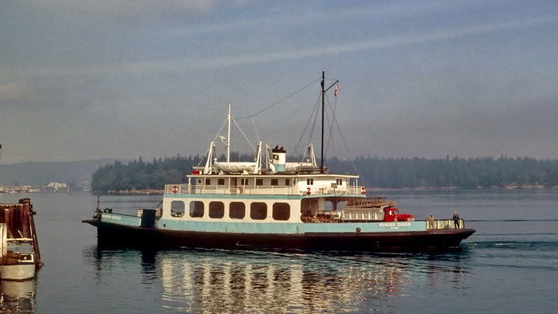 DOT collection DOT collectionI have shown this image of the Pender Queen / Motor Princess some time ago. The purpose this time is to show that it had side ramps in about the same place as on the Mayne Queen. It should be remembered that the MQ inherited the PQ's outer Gulf Island route in the mid 1960's. They must have had a purpose. |
|
pscurr
Chief Steward

Posts: 204
|
Post by pscurr on Jan 10, 2008 21:09:43 GMT -8
From a history of Pender Island • Side Loading Pender Queen/Mayne Queen After 1966, with the construction of the front end loading ferry slip at Otter Bay, ferries no longer called at the Hope Bay and Port Washington wharves. Demand for farm staples and supplies was further reduced with the change from an agricultural based economy to a residential/retirement community. The viability of the two general stores at Hope Bay and Port Washington was seriously compromised with the removal of their two post offices in 1979. The Hope Bay Store closed its doors as a grocery and general store a few years after this. Since 1979, the buildings at Hope Bay have been home to various Arts and Crafts stores such as Quatro Books (1991), the Galloping Moon Gallery , Stella Maris Gallery, ITZYU Designs and The Goldsmith Shop, the latter which still remains today. The buildings were razed in a fire in the early hours of Sunday, February 23rd, 1998. Reconstruction began a couple of years after the fire, but was not completed. The site was purchased in April of 2003 by a group of local Pender Islanders who have had a close association with Hope Bay in the past and want to rebuild it to restore its legacy of heritage and commercial purpose. Hope Bay Rising Company Ltd. hopes that, phoenix-like, 101 years after the business began, a new centre will emerge and once again provide space for commerce as well as a place for people to gather and enjoy the spirit of the rural Pender Island lifestyle. 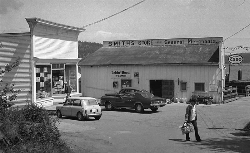 Hope Bay circa 1970-72 |
|
|
|
Post by Curtis on Jan 10, 2008 21:46:15 GMT -8
So...it was Pender Island That Needed the Side Loading Ramps?
BTW Nice Photo of the Pender Queen.
|
|
|
|
Post by WettCoast on Jan 11, 2008 17:59:33 GMT -8
In regard to the side ramps on the MQ & PQ, I emailed my brother and received back the following in two separate emails...
I will ask him to confirm whether or not cars were moved over these side ramps.
|
|
pscurr
Chief Steward
Posts: 204
|
Post by pscurr on Jan 11, 2008 18:38:12 GMT -8
West Coast Kid , Your brother and I worked through university with BC Ferries at the same time albeit from different sides of the pond. Now all we need is the photo of the Mayne Queen side loading at Saturna and the date Lyall Harbour became a front end only dock. It is been a good run on this thread. I really do not think the Mayne Queen docked at Hope Bay or Port Washington as the dates of Otter Bay's completion are close to the launch of the Mayne Queen. However do not know for sure. I wonder in the BC archives or BCF archives would have photo.
|
|
|
|
Post by WettCoast on Jan 11, 2008 19:08:05 GMT -8
More info from my brother...
|
|
|
|
Post by roeco on Feb 17, 2009 9:32:40 GMT -8
When Montague Harbour Terminal on Galiano was Closed back in the 90's how did they determine which one to Close or was Sturdies Bay not even considered.
|
|
Nick
Voyager  Chief Engineer - Queen of Richmond
Posts: 2,078 
|
Post by Nick on Feb 17, 2009 9:49:48 GMT -8
I think it's because the larger ships on route 9, like the Tsawwassen and Nanaimo couldn't easily fit into Montague Harbour. That was one of the reasons Sturdies Bay was used in the first place.
I think the other reason was because Sturdies Bay is much closer to Tsawwassen, and it's right on the route to the other islands, so ships on rt 9 can stop without making any major detours.
|
|
ProudCanuck
Chief Steward
Champ Car - Gone, but not forgotten!
Posts: 242
|
Post by ProudCanuck on Feb 17, 2009 10:26:14 GMT -8
Does anyone have any pics of the old Montague Harbour terminal? I have never seen any photos of it.
|
|
|
|
Post by WettCoast on Feb 17, 2009 22:53:20 GMT -8
|
|
|
|
Post by kerryssi on Feb 18, 2009 11:40:43 GMT -8
The dock was in very bad shape and needed a major rebuild. There is no space for parking and there is a steep hill right off the dock. The larger vessels would have a very difficult time getting into the harbour. Sturdies is much better.
|
|
|
|
Post by Dane on Feb 21, 2009 13:07:25 GMT -8
The million dollar question seems to be when BC Ferries disposed of this asset. It never appears in an annual report, at least in a way that I can read. I believe, but am not sure, that the land was transferred to BC Parks (because when I worked at BC Parks our facilities map included most of the formal terminal area - incidentally I think I am going back this summer if anyone wants to play with the ramp at Porteau  ). I sent a few e mails off to a few sources in Galiano, the museum and someone with the Island Trust but they had conflicting answers. When the terminal was held in reserve, according to a 1994 BC Ferries Gulf Island Service report, the Queen of Tsawwassen could serve the location, but the Nanaimo could not. |
|
Neil
Voyager
Posts: 7,171
|
Post by Neil on Feb 27, 2009 10:26:56 GMT -8
re: the Montague Harbour terminal-
Paul LeBlond from the Galiano historical society tells me that it was built in 1957, with government funding, for the Gulf Island Ferry Co. It was constructed with the Cy Peck in mind, so it's not surprising that operations involving much larger boats like the Queen of Cumberland might become problematic.
I'm not sure if he'll be able to supply any further info on Montague's history.
|
|
|
|
Post by Low Light Mike on Feb 27, 2009 10:56:50 GMT -8
re: the Montague Harbour terminal- Paul LeBlond from the Galiano historical society tells me that it was built in 1957, with government funding, for the Gulf Island Ferry Co. It was constructed with the Cy Peck in mind, so it's not surprising that operations involving much larger boats like the Queen of Cumberland might become problematic. I'm not sure if he'll be able to supply any further info on Montague's history. Neil: Do you see this Galiano choice of terminal-location as similar to Hornby, in wondering why the Hornby terminal wasn't placed at Ford's Cove? Not the same circumstance or reasons as with Galiano, but it makes you wonder why the various locations were picked over alternate sites. (maybe we've discussed this before?) |
|
|
|
Post by kerryssi on Feb 27, 2009 13:01:48 GMT -8
Some things to consider when locating a ferry terminal
1) distance to destination
2) availability and cost of land
3) room for expansion
4) availability of land for holding area and parking, how level is it.
5) exposure to weather/wave/tide
6) sea bottom conditions
7) will the location generate traffic
8) cost
9) pre privatization....need
|
|
Neil
Voyager
Posts: 7,171
|
Post by Neil on Feb 28, 2009 23:10:07 GMT -8
Neil: Do you see this Galiano choice of terminal-location as similar to Hornby, in wondering why the Hornby terminal wasn't placed at Ford's Cove? Not the same circumstance or reasons as with Galiano, but it makes you wonder why the various locations were picked over alternate sites. Although CPR ships did stop at Ford's Cove, the first government dock at Hornby was near Shingle Spit. The Savoies first started ferrying people to Comox from their property on the north end of the island, and they started their car ferry service from Phipps Point, later moving to Shingle Spit. The car ferry docks were built where the beach best allowed construction of the cement jetties; the Phipps location made for a fairly long sail across to Gravelly Bay. I believe that the road from the Spit to Ford's Cove was abandoned in the 1930s, which probably worked against the establishment of car ferry service down there. Perhaps Montague Harbour was established partly because ferries used to dock at Ganges on Salt Spring, and it would be a relatively short run across. |
|
|
|
Post by Low Light Mike on Mar 1, 2009 8:10:37 GMT -8
Regarding choice of location for ferry terminals:
Cortes Island is another example of where the present-day ferry landing is in a different location from the historical steamer landing.
Manson's Landing was the Union landing site, and I'm not sure of the historical use of the Whaletown location. I think that probably Whaletown because the ferry landing because of its location for the water-route across Sutil Channel to Heriot Bay (a straight line).
Manson's Landing also would have been a tight-fit to get into the harbour.
|
|
|
|
Post by kerryssi on Mar 1, 2009 15:48:18 GMT -8
I believe you have it right Neil, the original ferry was much smaller and there was less traffic. Montague is well protected and the old ferry would have had a hard time getting through Active pass against the tide.
One of the cost cutting measures in use for smaller terminals is to use floating ramps which rise and fall with the tides. This eliminates the need for a terminal attendant.
The exception is Vesuvius which, in the summer months is often overloaded and lane jumping is common. This leads to spirited discussions among the passengers with, at times black eyes and split lips resulting. They need a terminal attendant there in the summer.
A problem is the dock at Crofton. When they put in the floating ramp the ramp was quite short which results in low beds, motor homes, and buses ( and my 51 Merc) being high centered except at very high tide. This restricts its usefulness
|
|
|
|
Post by stvfishy on Jul 16, 2009 21:08:24 GMT -8
 hmmmmm duelling responses - o wellllllll Thanks for the good game, Jim. Do you have the reason or a theory on why Galiano had 2 terminals at the same time (Sturdies & Montague) ? I know that ferries to the mainland used Sturdies and those to Swartz Bay used Montague. Sturdies Bay, being more open, was perhaps seen as more difficult to get in and out of in rough weather for the smaller open car deck ferries running to and from Swartz. But my #1 suggestion as to why was to minimize traffic through Active Pass. Other thoughts: - Montague Harbour predates BC Ferries. Before there were direct connections to Tsawwassen there were only ferries to Swartz Bay. For ferries serving the Gulf islands out of Swartz Bay Montague Harbour would seem a more logical choice then Sturdies.
- I assume the closing of the Montague Terminal was done to save money. However, today all ferries serving Galiano have to transit Active Pass. The extra costs in doing so must be less then the costs of running two terminals.
- Salt Spring Is has three terminals. While Vesuvius terminal makes sense for the route to Crofton you have to wonder if they really need both Long Harbour and Fulford. For the same reason that they closed Montague would it not be less costly to run the Queen of Nanaimo out of Fulford, in spite of the somewhat longer distance involved?
I was going to guess Montague, but didn't feel certain enough. I can remember going with seascouts to the provincial park there to do our annual unduction ceremony of new members - with a little taste of hazing to boot, good times   - and well remember the island in the background as that's where we hicked to after dark to perform the necessary rituals. I can even remember the berth structures before they were presumably removed. Thanks, Jim. I remember going to Galiano Island when I was 10 and seeing the berth structures still intact. I believe that the structures were removed in somewhere between 1998 and 2000.
|
|
|
|
Post by Low Light Mike on Jul 16, 2009 21:22:33 GMT -8
Here is how the Montague ferry landing looked in 2007. It's the concrete thing on the left.  |
|
|
|
Post by stvfishy on Jul 16, 2009 22:00:35 GMT -8
From demo.geogarage.com/noaa/ (depths in fathoms - I think)  Flugel Horn - can you map out the location of the terminal and the route in? Looks like a tight/shallow squeeze through the channel around what they are calling Julia I. Or go around the west side of the bigger island in the middle(Parker) - also looks shallow - 2 fathoms? |
|
|
|
Post by Scott on Jul 16, 2009 22:07:24 GMT -8
I'm quite certain the terminal is almost exactly where it says "Montague Harbour" on the map.
|
|


 ).
). 
 hmmmmm duelling responses - o wellllllll

 - and well remember the island in the background as that's where we hicked to after dark to perform the necessary rituals. I can even remember the berth structures before they were presumably removed. Thanks, Jim.