|
|
Post by Ferryman on Jun 28, 2007 21:34:53 GMT -8
Well, I just happened to come across this by chance. I don't know exactly how recent this was posted on their website...But it's sure neat to see. You can see where the Northern Adventure, Queen of Prince Rupert, and Queen of Chilliwack are on this page. EDIT: I'm noticing now I have a different vessel tracking page bookmarked in my favourites, that is slightly different than the one that is shown through direct links on the website...So you probably won't see this on the actual page everyone sees for a little while. Enjoy! pathfinder.applocation.net/bcferries/route13.html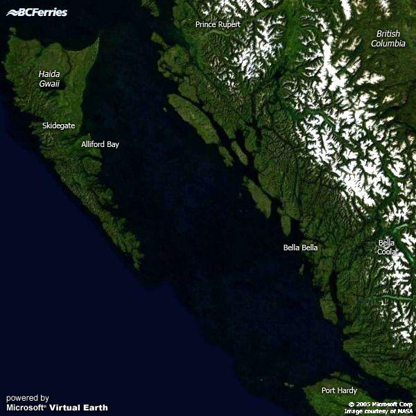 For other GPS locators, click on the link below. pathfinder.applocation.net/bcferries/routes.html |
|
|
|
Post by Coastal Drought on Jun 28, 2007 21:49:07 GMT -8
Strange enough that its not on the BC Ferries website yet.
|
|
Mirrlees
Voyager  Bathtub!
Deck Engineer- Queen of Richmond
Bathtub!
Deck Engineer- Queen of Richmond
Posts: 1,013
|
Post by Mirrlees on Jun 28, 2007 21:53:04 GMT -8
Thanks for the heads-up Chris, now we can spy on our northern ships too.  |
|
|
|
Post by WettCoast on Jun 28, 2007 21:57:06 GMT -8
If you hover over one of the ship icons on the Northern Passage page you get a close up of the vessel's position. This is good!
|
|
|
|
Post by Coastal Drought on Jun 28, 2007 21:58:41 GMT -8
I concur.
|
|
|
|
Post by Low Light Mike on Jun 29, 2007 3:44:54 GMT -8
Thanks Chris. That will be an interesting page to monitor.
|
|
|
|
Post by Northern Exploration on Jun 29, 2007 6:24:46 GMT -8
Good eye Chris. I am curious though something seems to be off in the icon for the ship and the map. At this time 10:22am EST or 7:22 PST it has the ship heading directly into the large Island off Prince Rupert. Don't have time to get my map of the Inside Passage out to check the name but it seems some calibration is needed.
|
|
|
|
Post by Northern Exploration on Jun 29, 2007 6:45:49 GMT -8
It is ok I refreshed and the icon moved into the proper position. Strange. Although it lists the QPR destination as Port Hardy but it appears to be coming from QCI to Prince Rupert. NorAd also just left Port Hardy on its way to Prince Rupert and it lists the destination as Port Hardy. So some fine tuning must still be to come.
|
|
|
|
Post by Northern Exploration on Jun 29, 2007 7:32:22 GMT -8
Since it isn't officially on the BC Ferries Public Site yet, Chris must have gotten the link to a beta version hence some of the tweaking still needed. Good sleuthing Chris. And oh my Fluge's flying ferry is for real cause the Chilliwack is now on top of a mountain hahaha.
|
|
|
|
Post by DENelson83 on Jun 29, 2007 8:33:54 GMT -8
And oh my Fluge's flying ferry is for real cause the Chilliwack is now on top of a mountain hahaha. It's just 'cuz the GPS signals are weak in all that high mountain cover, and hence the accuracy of the GPS fix isn't all that great. I should know 'cuz I took a GPS receiver through Goldstream Park and it completely lost the signal there. |
|
|
|
Post by Northern Exploration on Jun 29, 2007 15:19:16 GMT -8
Everything seems to working well now. Maybe the bugs will be fixed and it will be included in the main site soon.
|
|
|
|
Post by NMcKay on Jun 29, 2007 15:27:35 GMT -8
its not weak. it just cant find 3 satellites to make a corresponding location
|
|
|
|
Post by Barnacle on Jun 29, 2007 15:35:11 GMT -8
That is, by definition, a 'weak' or 'inadequate' GPS signal.  If it can't get three satellites for a two-dimensional fix (it takes four to sort out altitude), then you have position ambiguity. Very few populous areas have this problem, nor have they for about twelve years. |
|
|
|
Post by WettCoast on Jun 29, 2007 16:04:17 GMT -8
I do not believe that the GPS systems on BC Ferries vessels would ever have a problem 'seeing' enough of the sky to get a 'fix' on at least 4 GPS satellites for a good 3 dimensional position. Furthermore, they should usually be able to get a fix from a WAAS satellite which provides differential corrections for the other satellites such that the positions should be known within a few metres accuracy. This I base on experience using a handheld Garmin GPS in a car, and when hiking. The only time I have a problem is when hiking under thick tree cover. The inaccuracy shown on these maps is due to either software or the small scale of the maps.
|
|
|
|
Post by DENelson83 on Jun 29, 2007 16:57:59 GMT -8
Furthermore, they should usually be able to get a fix from a WAAS satellite which provides differential corrections for the other satellites such that the positions should be known within a few metres accuracy. The thing is, for WAAS to work in a given location, there has to be a DGPS ground station near that location sending its correction data to the WAAS satellites for distribution. If there's no such ground station within about 200-300 km of your present location, WAAS isn't really useful, and since the ground stations that support WAAS are only located on U.S. soil, I don't think that WAAS would really help on the B.C. Mid-Coast. |
|
|
|
Post by WettCoast on Jun 29, 2007 22:45:21 GMT -8
For more on GPS & WAAS check out this site: members.shaw.ca/pdops/WAAS.htmlIn the last year two new WAAS satellites (#'s 48 & 51) have gone into service vastly improving accuracy in the northern half of North America. Even if true accuracy is not as good as that reported on the GPS it is still within ~ 5 metres. New reference stations have also been added in the northern US Lower 48 plus Alaska, and across Canada. The accuracy is good. |
|
|
|
Post by Curtis on Jul 1, 2007 11:17:33 GMT -8
This is going to be an awesome feature. ;D
I love it already.
|
|
|
|
Post by Northern Exploration on Jul 1, 2007 17:47:57 GMT -8
Well tonight the QofPR is in port at Skidgate and it shows the destination to be Port Hardy. The northbound NorAd is approaching the spot where the QoftN went down and her destination is listed as Skidgate. The QofChilli is the only one correct as it is listed as Bella Coola.
|
|
|
|
Post by DENelson83 on Jul 2, 2007 11:36:48 GMT -8
If [the GPS receiver] can't get three satellites for a two-dimensional fix (it takes four to sort out altitude), then you have position ambiguity. Don't forget that if you can pick up signals from four GPS satellites spaced far apart in the sky (a low-enough DOP), you can also get the exact time of day. |
|
|
|
Post by Barnacle on Jul 2, 2007 12:39:08 GMT -8
Very true! We use the GPS clock as official fleet time these days.
|
|
|
|
Post by Low Light Mike on Jul 12, 2007 17:40:58 GMT -8
I have really been enjoying the Northern GPS page. In the evenings when I see where the NorAd is, on her day-cruise, it reminds me of when I took the inside-passage in 2004...remembering where we were at that time of day. Also, the Chilliwack one is interesting. It's neat to realise how far inland BellaCoola is. And I like the detailed zoom-in maps for each ship. The map-nerd in me is satisfied.....  |
|
|
|
Post by Low Light Mike on Jul 17, 2007 17:32:26 GMT -8
From the latest edition of the Queen Charlotte Observer newspaper: ================= www.qciobserver.com/Article.aspx?Id=2781Tracking the ferries feature soon available By the end of the summer, islanders with access to high-speed internet will be able to track the travels of the Queen of Prince Rupert and the Northern Adventure in live time, says BC Ferries spokesperson Deborah Marshall. The GPS technology that allows people to check out where ferries are over the internet is already in place on the southern routes, and it's coming soon to the northern routes, Ms Marshall said. "We're just finalizing the infrastructure," she said. "It will be great for everybody up north." North Coast MLA Gary Coons, who is the NDP's critic for ferries, told us that he has seen a version of the vessel tracking for northern routes. We checked it out at pathfinder.applocation.net/bcferries/route13.html on Monday afternoon and it was amazing, clearly showing the location of all three northern route vessels, their speed, and their destination, in live time, refreshed every minute. created July 16, 2007 5:04 PM ======================== (and here's a bonus to you all) www.qciobserver.com/Article.aspx?Id=2782Ferries has new number BC Ferries has just set up a new phone number dedicated to the northern routes. Spokesperson Deborah Marshall said islanders who phone the 1-800 number will first hear a recording, but could end up speaking to a staff member at the Skidegate or Prince Rupert ferry terminal if they are available. The number gives callers options for making reservations, getting the latest arrival and departure information, or reporting lost and found items. The new number is 1-877-223-8778. created July 16, 2007 5:04 PM =============== |
|
|
|
Post by Northern Exploration on Jul 17, 2007 17:52:18 GMT -8
Everytime I check it lately the Northern tracking seems to be working fine now. I really love it.
|
|
|
|
Post by Northern Exploration on Jul 25, 2007 7:23:02 GMT -8
|
|
|
|
Post by Coastal Drought on Jul 25, 2007 22:26:59 GMT -8
Link doesn't work.
|
|


 If it can't get three satellites for a two-dimensional fix (it takes four to sort out altitude), then you have position ambiguity. Very few populous areas have this problem, nor have they for about twelve years.


