|
|
Post by Curtis on Aug 11, 2010 11:23:21 GMT -8
|
|
|
|
Post by Retrovision on Aug 21, 2010 21:57:43 GMT -8
Westview Wait a second (and apologies for the late reply), is that a ship alongside the old Westview Pier? I had thought for sure that it was condemned to one degree or another. Between our forum's member Shane's words about it in the past and that great barrier chainlink fence, I didn't think that Powell River (or whoever controls it) was accepting moorage. Then again, that electrical box near the end has always seemed very potentially active to me. Any clarification would be welcome, Ship-Rider 16, though now that I look closer it seems that this vessel seems to be a work vessel of some sort; if so, any word on the work that it's doing? Thanks ahead of time. (Forgive me if I've missed a post about this work on our vast forum, am still catching-back-up) |
|
|
|
Post by Curtis on Aug 21, 2010 23:05:41 GMT -8
Ships do dock at the pier on occasion, often the WestNav barge occupies that space. I believe the construction you see has to do with the Wharf at Westview Project that started this past Spring. I currently doubt the pier will be open to the public when they are done, but the drawing on the project page could prove me wrong. |
|
Mill Bay
Voyager  Long Suffering Bosun
Posts: 2,886 
|
Post by Mill Bay on Aug 22, 2010 13:10:07 GMT -8
Ships do dock at the pier on occasion, often the WestNav barge occupies that space. I believe the construction you see has to do with the Wharf at Westview Project that started this past Spring. I currently doubt the pier will be open to the public when they are done, but the drawing on the project page could prove me wrong. As further validation: I have also seen Marine Link Tours MV Aurora Explorer tied up at the pier in Westview, as well as the ship in the previous photo and various barges and working vessels at odd times. |
|
|
|
Post by Low Light Mike on Sept 20, 2010 14:17:17 GMT -8
|
|
piglet
Chief Steward

Posts: 138
|
Post by piglet on Oct 8, 2010 18:48:01 GMT -8
Back on the 20th Flugel Horn ask about the marker infront of the house at Little River. The answer to your question Flugel Horn is partially answered in the forth pic you posted in that set. The triangle (point to top) in the forth pic when lined up from the sea side with the one infront of the house will line you up directly with the channel which I would expect would lead to the dock. Upright and inverted triangles are separated so you have to be in the right position to be in the right place, its supposed to be fool proof.
|
|
|
|
Post by lmtengs on Oct 8, 2010 18:58:05 GMT -8
Back on the 20th Flugel Horn ask about the marker infront of the house at Little River. The answer to your question Flugel Horn is partially answered in the forth pic you posted in that set. The triangle (point to top) in the forth pic when lined up from the sea side with the one infront of the house will line you up directly with the channel which I would expect would lead to the dock. Upright and inverted triangles are separated so you have to be in the right position to be in the right place, its supposed to be fool proof. Thanks, Piglet! That sounds interesting. I should look for that next time I sail that route. That was actually me who asked the question. Flugel Horn had quoted a post I'd made awhile back, in August of last summer. ;D Welcome to the forum! Just with that one post you've already made a worthwhile contribution here, and your membership is appreciated  |
|
|
|
Post by Low Light Mike on Nov 9, 2010 13:18:50 GMT -8
Temporary shutdown of Little River terminal, sometime between April 2011 and March 2012:
Here's an excerpt from the recent "Performance Term 3 submission" report:
I don't know how long the terminal would be non-operational for, but this project and the temporary shutdown would allow for an interesting temporary route (do your brainstorming), or maybe just no replacement route at all.
We'll see what happens.
|
|
|
|
Post by lmtengs on Nov 9, 2010 15:19:25 GMT -8
Would the Queen of Burnaby fit into the Campbell River ferry terminal? I know there's a weird turning angle to get in there, so I'm not sure if she'd be able to fit. If she does, that would be an alternate.
If not, maybe a smaller vessel could fill in for her, one that actually fits at Campbell River, and run between there and Westview. Maybe NIP could alternate routes, running on her normal route, then 4 or 5 times a day (maybe 5, due to her lower capacity), she could do a round trip to Campbell River from Westview. Possible? Not?
|
|
|
|
Post by Nickfro on Nov 9, 2010 16:07:55 GMT -8
I don't know how long the terminal would be non-operational for, but this project and the temporary shutdown would allow for an interesting temporary route (do your brainstorming), or maybe just no replacement route at all. We'll see what happens. I think sailing disruptions and berth closures will be kept to a minimum. Like what was done at Quathiaski Cove earlier this year, I would guess that a Little River berth closure of 4-7 days might happen to get the major replacement work done. At that time, it would probably be the long way around as the only detour, as no other option seems feasible to do, except for options arising from ferry geek dreams. ;D |
|
|
|
Post by Scott on Nov 9, 2010 23:43:49 GMT -8
I don't know how long the terminal would be non-operational for, but this project and the temporary shutdown would allow for an interesting temporary route (do your brainstorming), or maybe just no replacement route at all. We'll see what happens. Would a passenger-only water taxi work for that distance? It would at least keep any essential connection intact, like for school/hospital reasons. But if they give enough warning beforehand, most people could probably plan their lives around it if it was just for a week. |
|
|
|
Post by Ferryman on Nov 10, 2010 0:06:54 GMT -8
This is a substantial amount of work that needs to be done. I could see this taking a few months at least....this is with using Tsawwassen as a bit of a size comparison scale. Especially with the new ramp configuration, an new turning dolphin. Will be interesting to watch this all unfold. Any alternative routing to Buckley Bay or Campbell River just seems so unrealistic to me, and would be surprised if they actually consider this. I have feeling they might just have everyone rely on the Sunshine Coast routes for the time being, and perhaps offer a discount for people coming from Powell River, and transfering from Route 3 to Route 2.
|
|
Mill Bay
Voyager
Long Suffering Bosun
Posts: 2,886
|
Post by Mill Bay on Nov 10, 2010 8:01:59 GMT -8
I think, more sensible than using Campbell River, or Buckley Bay, they might consider having a few sailings going from Departure Bay directly to Langdale, to connect with the Sunshine Coast highway, and allow people trying to get to Powell River from the island to at least bi-pass HSB in the rush.
Both Campbell River and Buckley Bay are unlikely. No major vessel could possibly fit into the berth area in Campbell River, and I doubt Buckley Bay has that capacity either. If anything like that were to happen, it would be a severely reduced essential service levels only, with one of the minor vessels as relief.
|
|
|
|
Post by fargowolf on Nov 10, 2010 16:38:21 GMT -8
, an new turning dolphin. Turning dolphin?  What does it do exactly? |
|
|
|
Post by Low Light Mike on Nov 10, 2010 16:45:06 GMT -8
, an new turning dolphin. Turning dolphin? What does it do exactly? Wiki article: en.wikipedia.org/wiki/Dolphin_(structure)...but that doesn't really explain the "turning" part: - the turn meaning is that a ship can use the structure as a fulcrum when it is turning into the berth. Usually in very stormy weather. |
|
|
|
Post by fargowolf on Nov 11, 2010 13:20:22 GMT -8
That's what I figured, but wasn't sure. Basically, it's a pivot point for the ferry, as she reverses into the slip.
|
|
|
|
Post by deepsea on Nov 12, 2010 4:00:34 GMT -8
This is the best example of using a dolphin to leave, in middle of a stormy weather.
|
|
|
|
Post by Low Light Mike on Nov 25, 2010 18:10:38 GMT -8
Little River terminal, in May 2009: - take a look at how low the tide is.  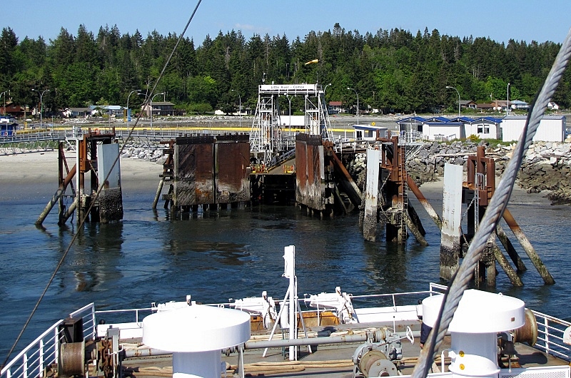 The low-tides were a problem for the ferry Queen of Chilliwack, during that week of very-low tides. |
|
|
|
Post by lmtengs on Nov 27, 2010 19:22:25 GMT -8
Some photos, taken last weekend on November 21st, 2010: Westview Terminal:  From the car deck of the Queen of Chilliwack, filling in for the 'Burnaby.  The trestle and vehicle ramp, with the 'Wack in the background.  The waiting room, with the Chamber of Commerce building forming that very sharp-peaked A-frame in behind.  Construction signs at Westview. They're working on that condemned wharf and building a Spirit Square. (I know this pic was already posted in a different thread, but it would be easier to find here.)  A sign directing any travelers to the terminal. Moving on to Earls Cove...  The new berth (above), and the old berth (below).  And lastly, Langdale Terminal...  The lane-assignment booth. I like the maximum speed ;D The sign for the route 13 ferry:  The berthside crew walkway:     A dark picture of the walkway back to the main terminal from the Langdale Float.  Foot passengers need only to click a button to get their boarding passes. |
|
|
|
Post by lmtengs on Nov 28, 2010 0:56:01 GMT -8
 Does this have to do with the airport, or the ferry terminal? Back on the 20th Flugel Horn ask about the marker infront of the house at Little River. The answer to your question Flugel Horn is partially answered in the forth pic you posted in that set. The triangle (point to top) in the forth pic when lined up from the sea side with the one infront of the house will line you up directly with the channel which I would expect would lead to the dock. Upright and inverted triangles are separated so you have to be in the right position to be in the right place, its supposed to be fool proof. Thanks, Piglet! That sounds interesting. I should look for that next time I sail that route. That was actually me who asked the question. Flugel Horn had quoted a post I'd made awhile back, in August of last summer. ;D Welcome to the forum! Just with that one post you've already made a worthwhile contribution here, and your membership is appreciated On my last trip through Little River, on November 21st, 2010, I managed to get both of those triangles in one shot:  |
|
|
|
Post by Ferryman on Nov 28, 2010 4:31:54 GMT -8
Those "triangles" are actually called range markers. Route 17 vessels steer on them when coming back from Powell River. When the two lights are in a vertical line of each other, that means you're heading for safe water. Which in this case means the safest way into the Little River Berth. It also appears that with the way the markers would line up, the triangles would indicate which cardinal point you're steering on. With the two triangles pointing towards each other, this would indicate "West" which is most likely the direction (roughly) you're heading. www.usps.org/national/coch/CoChPage34.htm |
|
|
|
Post by DENelson83 on Jan 6, 2011 18:08:21 GMT -8
It also appears that with the way the markers would line up, the triangles would indicate which cardinal point you're steering on. With the two triangles pointing towards each other, this would indicate "West" which is most likely the direction (roughly) you're heading. Actually, I don't think that's the case. They're nothing more than range marks. So-called "cardinal marks" indicate the direction in relation to the mark in which safe water lies. |
|
|
|
Post by lmtengs on Jan 6, 2011 19:22:58 GMT -8
It also appears that with the way the markers would line up, the triangles would indicate which cardinal point you're steering on. With the two triangles pointing towards each other, this would indicate "West" which is most likely the direction (roughly) you're heading. Actually, I don't think that's the case. They're nothing more than range marks. So-called "cardinal marks" indicate the direction in relation to the mark in which safe water lies. They are cardinal marks. Otherwise, there wouldn't be the lining-up triangles. I asked a crew member on the Queen of Coquitlam who had worked on the 'Burnaby in the past, and he confirmed the cardinal navigation point theory. |
|
|
|
Post by DENelson83 on Jan 10, 2011 20:48:24 GMT -8
Actually, I don't think that's the case. They're nothing more than range marks. So-called "cardinal marks" indicate the direction in relation to the mark in which safe water lies. They are cardinal marks. Otherwise, there wouldn't be the lining-up triangles. I asked a crew member on the Queen of Coquitlam who had worked on the 'Burnaby in the past, and he confirmed the cardinal navigation point theory. The rear, upper triangle is pointing down, while the front, lower triangle is pointing up. If these range marks were also serving as a cardinal mark, wouldn't they be saying safe water lies due west of them, and wouldn't they be painted yellow-black-yellow? I think that crew member wasn't remembering his sea marks properly. When you visually line up the downward triangle on the rear mark with the upward triangle on the front mark, that means you are on course. It's sort of the maritime counterpart to what aviators would know as a VASI (visual approach slope indicator). The triangles are there because the red lights can't readily be seen from a distance during the day. |
|
|
|
Post by lmtengs on Jan 10, 2011 21:17:19 GMT -8
Are you sure that they mean ONLY that the safe water is due west of them? I took it to mean that if you sail in a westerly direction towards them, you're in safe water as well. If they're just in the single configuration, that being one above the other on ONE buoy, it means what you said, but when placed on land in that configuration, it means what I previously stated. EDIT: I think I'm wrong, I just checked on the map and the poles aren't even along a latitudinally sound line. They're telling you to sail in a south-westerly direction towards them. So yeah, not cardinal.  |
|


 What does it do exactly?

