|
|
Post by Balfour on Jul 13, 2009 9:49:13 GMT -8
Interesting...
I'd like to see what Dane has to say about that...
|
|
|
|
Post by Ferryman on Jul 13, 2009 9:49:31 GMT -8
Why would anyone from Deep Cove need to Belcarra? Or the other way around for that matter. Who's going to pay for that route? Besides, for the amount of time it would save, it would be easier just going to the Second Narrows bridge. Most people from North Vancouver are heading to Downtown Vancouver, or Burnaby. It would be a real pain to take a Ferry, and then fight your way through Port Moody. Besides, I could see those massive infrastructure plans not sliding well with the residents claiming, "I was here first".
Sorry to crap on your idea bud, but I don't think we're going to see any massive water crossing changes like this for a long time now. The existing bridges will see all of the changes and improvements as they all expire one by one. Ie: Patullo, Port Mann, etc...
|
|
|
|
Post by lmtengs on Jul 13, 2009 10:04:35 GMT -8
many people would go there to get to horseshoe bay using that route from Port Moody, Coquitlam, PoCo, Pitt Meadows, Maple Ridge, and Mission. It would be faster during rush hours, because there aren't very many commuters that go from the above areas to North Van, or the other way 'round. And it would take those extra cars off hwy 1 and the barnet, which would probably reduce congestion there just a small bit. And, it would be faster for people to get to north van this way then taking the round-about route that hwy 1 takes, then backtracking on the dollarton. Much more straightforward.
people who ride that route.
Same thing happened with the Golden Ears bridge, but it went through. Same thing happened with Sea to sky and the Eagle Ridge Bluffs, and it went through too. Why couldn't this?
I know, I know, it's all only fictional... at least for the time being.
|
|
|
|
Post by Dane on Jul 13, 2009 10:11:19 GMT -8
I would just like to point out my house is in that Google aerial view of Deep Cove. Beyond that I have no meaningful content to add to this thread.
|
|
Mill Bay
Voyager  Long Suffering Bosun
Posts: 2,886 
|
Post by Mill Bay on Jul 13, 2009 10:17:23 GMT -8
Why would anyone from Deep Cove need to Belcarra? Or the other way around for that matter. Who's going to pay for that route? Besides, for the amount of time it would save, it would be easier just going to the Second Narrows bridge. Most people from North Vancouver are heading to Downtown Vancouver, or Burnaby. It would be a real pain to take a Ferry, and then fight your way through Port Moody. Besides, I could see those massive infrastructure plans not sliding well with the residents claiming, "I was here first". Sorry to crap on your idea bud, but I don't think we're going to see any massive water crossing changes like this for a long time now. The existing bridges will see all of the changes and improvements as they all expire one by one. Ie: Patullo, Port Mann, etc... Not to mention the fact that people on the North Shore freaked out at the very mention of the possibility of a new highway that would have followed Indian arm up around behind the Lions and Stawamus Chief and come back into Squamish through the Stawamus Valley, bypassing the now wonderfully upgraded Sea-to-Sky highway. None of them are willing to let anything take place in or near the Seymour Watershed, and they have the environmental concerns to bolster their objections. Besides which, I've seen the type of residences there are up in Belcarra. Not that they couldn't afford to pay for the infrastructure, but they wouldn't either, because they don't really need to worry about what gas costs. They certainly would not want anyone marring the viewscape but cutting a swath through those nice forests in their backyards. Add to that the fact that Belcarra is a park, and you've just about got the deal sown up. Chris is right. The only improvements they will make in the future will be to the existing bridges that need it. Forget the fact they will all end up being cable-stayed monsters that are not unique to look at all. (Hey, we build what is cheapest, right). We'll actually be lucky if it does happen, and we are guaranteed, now, to pay through the nose for it, too, a la the Golden Ears Bridge. In addition, the plans for the Port Mann and Pattulo both indicate that our societal leaders (if we ever had any) are still only concerned with trying to move more cars than trying to get people out of them, so a ferry route across Indian arm that looks like at least a twenty minute crossing also wouldn't get anyone anywhere they wanted to go as fast as they wanted to go. The population centres of the Lower Mainland, the Island and even the Gulf Islands are pretty much fixed, so we will likely not see any new ferry routes any time soon because there will be no new centres of commerce or population suddenly opening up to justify new terminals and routes. True, existing population centres are growing like a plague, but ferries can't serve landlocked areas and everything is ultimately just going to be connected by more roads anyway once the cars are off the ferry and on the land. |
|
|
|
Post by lmtengs on Jul 13, 2009 10:25:37 GMT -8
aww, that ruined all my fun.  |
|
Mill Bay
Voyager
Long Suffering Bosun
Posts: 2,886
|
Post by Mill Bay on Jul 13, 2009 10:30:36 GMT -8
aww, that ruined all my fun. Yeah, just goes to show that ferry route planning is not all fun and games  . I do hope we at least see one of them go to Prince Rupert to operate as their airport ferry, but then we'd have another poor little ferry out of a job. |
|
|
|
Post by Low Light Mike on Jul 13, 2009 10:38:59 GMT -8
aww, that ruined all my fun. A couple of years ago, we had a member propose a new route from Galiano Island to Gabriola Island, just because the islands were relatively close to each other. However, when we questioned him on the obvious logistical & geographical limitations to his plan, we never heard back from him. He wasn't interested in discussing to that level of detail; just wanted to keep it at the fantasy level. So props to you for discussing your idea (the Belcarra / Deep Cove one) and showing your plans and backing it up with your reasonings. Discussing the reasons why potential routes can and can't work can be interesting discussion. Backing up the seemingly unrealistic assumptions with reasonings is the key. |
|
|
|
Post by Kahloke on Jul 13, 2009 11:13:05 GMT -8
And many years ago, like back in the 50's and 60's (I think), there were somewhat serious discussions around replacing many of the Puget Sound ferries with cross-sound bridges, and even running bridges out to the San Juan Islands. Those ideas were all shot down, too.
|
|
Koastal Karl
Voyager
Been on every BC Ferry now!!!!!
Posts: 7,747
|
Post by Koastal Karl on Jul 13, 2009 11:22:47 GMT -8
According to the translink site the last chance to drive the Golden Ears Bridge for free is before midnight Wednesday. I was thinking of doing a day trip to Van to ride the Albion Ferries that day and thought of maybe seeing this new bridge. I dident even know before today where the bridge was and even how to get there.
|
|
|
|
Post by Nickfro on Jul 13, 2009 11:33:59 GMT -8
For rt1commuter.... Heres' 76.5 AEQ's on a 26 car boat! 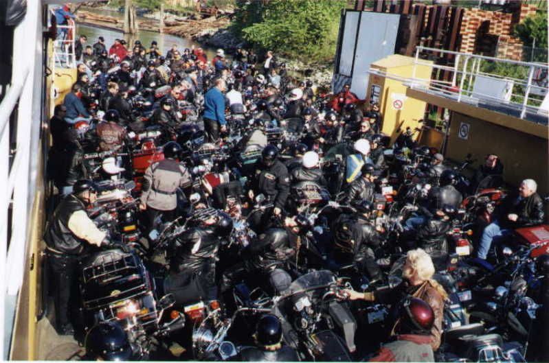 How many motorbikes can you stuff on an Albion Ferry?? ;D Love that photo. Sounds like there should be a separate thread established for speculating new ferry routes. They sure do bring on some interesting discussion, even if such routes are quite out to lunch in reality. |
|
Mill Bay
Voyager
Long Suffering Bosun
Posts: 2,886
|
Post by Mill Bay on Jul 13, 2009 13:39:44 GMT -8
|
|
|
|
Post by Dane on Jul 15, 2009 10:39:55 GMT -8
Having reflected on this "proposed" for fun ferry route, I think I will add some supportive comment. But I also just decided to take a ferry trip, so need to leave my house - therefore, I'll be brief.
The desire, albeit passive and infrequent, to have a bridge from the Deep Cove/Dollarton area to "the other side" is actually based on a real desire and the thought that there is indeed a transit market to be had.
Deep Cove and the surrounding communities are beautiful, it will be hard to leave when I decide to take adulthood seriously, but in terms of transportation can be hugely frustrating. With the Iron Workers Memorial Bridge being located at the Second Narrows we (Seymour East) residents drive West, just to go East again. An example would be this Monday where I went to attend a funeral near the Costco in Port Coquitlam. My route was an open top circle. Al Gore would not approve. In my younger days, five months ago, I was also a student attending SFU. I can see the Academic Quadrangle (large campus building) from my house, but again I drove well away from the institution to get there.
Having a connection to the East would make sense, for me, but with a population base of only about 20,000 living anywhere near East of Seymour we certainly do not justify I very large expenditure. Bus service here is also fantastic, despite the constant cries of residents.
There is also a geographic feature which would limit the location of a terminal on the North Shore side; WASP lawyers are common throughout the area and are very difficult to blast out. I'm not even sure Keiwett could do it.
|
|
Mill Bay
Voyager
Long Suffering Bosun
Posts: 2,886
|
Post by Mill Bay on Jul 15, 2009 20:54:54 GMT -8
All dreaming aside... I went for another trip across the Albion ferry tonight, as part of a trip to take my sister out to see the Golden Ears Bridge and drive across it a couple more times before tolling comes into effect. (I would laugh if their software malfunctions, and people end up getting a few more days crossing the bridge toll free.)
It was interesting today, because I drove up on the Ft Langley side and literally straight onto the ferry which was loading just at that time. It was the Kulleet, again, for the quadrillion to one odds Neil is wagering, but that's o.k. with me, I like taking pics of the Klatawa better because her name looks nicer to read in pictures. Anyway, the Klatawa got away faster from the Albion side, and was already halfway across the river while we were still loading, so the captain on Kulleet cheated. As the Klatawa waited just off the dock, as soon as we were loaded, he angled her just out of the berth, and then took off backwards up the river instead of passing alongside the Klatawa as normal.
Away we went the wrong way up the river until about two-thirds the way across, and the captain revved up both RADS and spun the ship right in the river, then he had to sort of bring her around in at an unusual angle to get the cars facing the berth at the right end again. I took pics, but I never seem to clue in when I should be taking videos, because it might have been to record the ferry going backwards like that.
|
|
D'Elete BC in NJ
Voyager
Dispensing gallons of useless information daily...
Posts: 1,671
|
Post by D'Elete BC in NJ on Jul 16, 2009 6:01:32 GMT -8
|
|
|
|
Post by Queen of Nanaimo Teen on Jul 20, 2009 9:45:07 GMT -8
I just got off the Albion Ferries about an hour ago. Just did the Klatawa from Ft. Langley and back, but it was fun! They even let me up to the bridge to get pictures of the builders plaques . I hung around after, and they let me board the Kulleet to get some shots (Lifering, etc.). I'm going to miss them a lot, hopefully they end up in good hands! (Photos will be posted later this afternoon) |
|
Koastal Karl
Voyager
Been on every BC Ferry now!!!!!
Posts: 7,747
|
Post by Koastal Karl on Jul 21, 2009 8:38:14 GMT -8
Are both Albion Ferries running or are they just using one right now??? I am still trying to see if I can get over there before the 31st!
|
|
|
|
Post by lmtengs on Jul 21, 2009 11:34:19 GMT -8
they're running both. I biked by there last week.
|
|
|
|
Post by Queen of Nanaimo Teen on Jul 21, 2009 11:38:41 GMT -8
Funny, I went to take the ferries, as had no photos of myself on the Klatawa, so I was hoping the Kulleet curse wouldn't follow . So, as soon as we pulled into the parking lot, and I went running onto the dock, the Klatawa was loading! It was perfect timing! They even waited for me! (They could have left) Both ferries are running, but none of the sailings seem to be completely full. Here are the pictures: Klatawa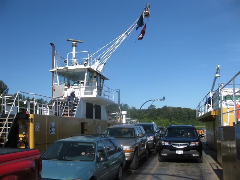 Apparently the plaques had "fallen off", and they had to put them up in the bridge.... 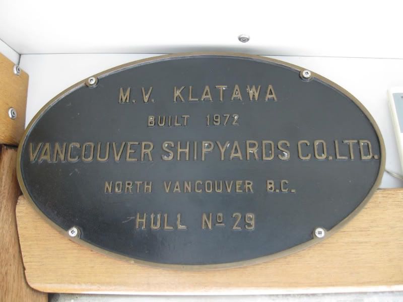 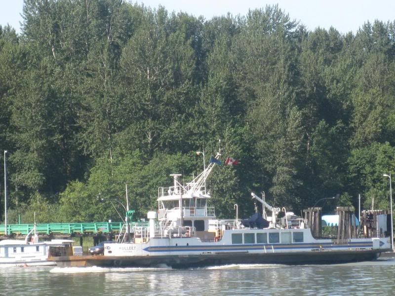 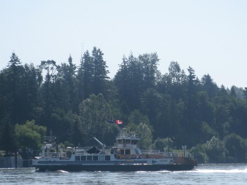 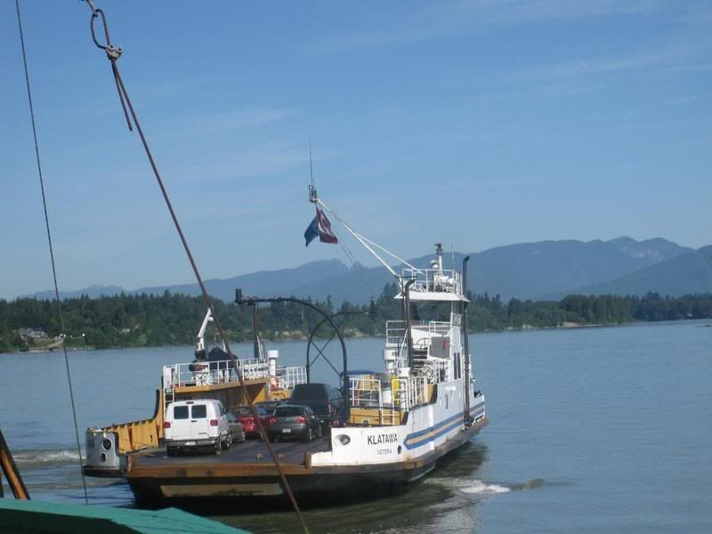 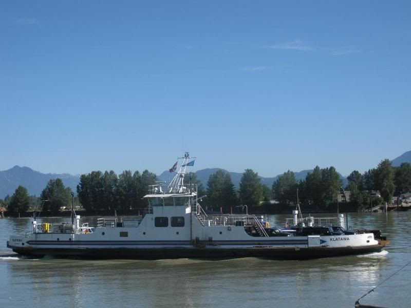 I wish I could have gotten a better shot of them together, but this is all I got.... 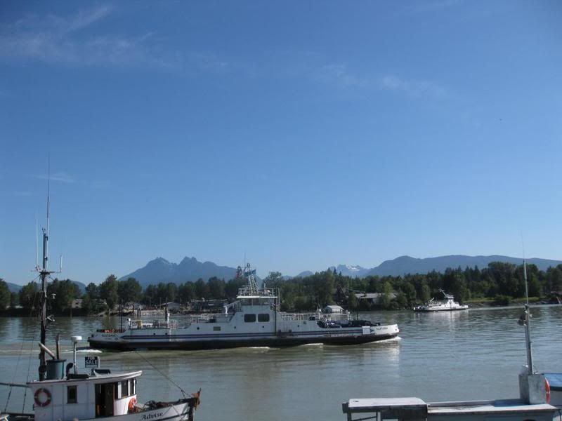 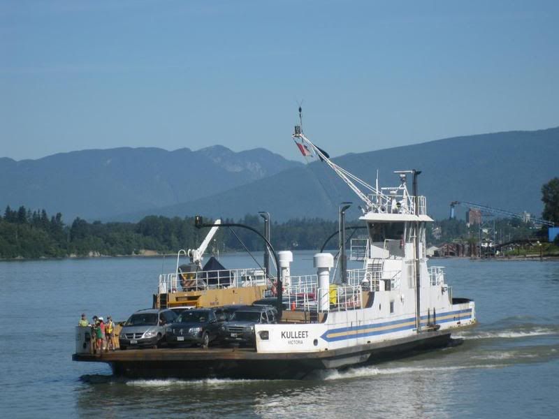 Last time I'll ever see them in active service  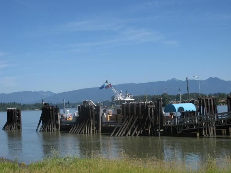 I was so fortunate to have a sunny day, they sure looked good! Gotta Loooooooooooove the K Class ;D QoNT |
|
|
|
Post by fargowolf on Jul 22, 2009 19:39:33 GMT -8
Awesome pics. Like everyone else, I'm sure gonna miss them. |
|
Mill Bay
Voyager
Long Suffering Bosun
Posts: 2,886
|
Post by Mill Bay on Jul 23, 2009 11:33:14 GMT -8
|
|
|
|
Post by Ferryman on Jul 28, 2009 18:24:39 GMT -8
|
|
|
|
Post by Mike C on Jul 28, 2009 18:38:31 GMT -8
The August transit pass, ironically, is a photo of the Albion Ferries. For those who buy monthly passes for transit in Vancouver will find this incredibly ironic, much like I did when I first saw it... maybe it's some sort of tribute? I don't know, Translink has a tendancy to reuse photos from months past, so we may see this photo come up again bout a year from now........
|
|
|
|
Post by Scott on Jul 28, 2009 21:33:01 GMT -8
Where would two K-barges be needed up north? I could see one on the airport route, but wouldn't just one be an improvement in service, let alone two?
|
|
Mill Bay
Voyager
Long Suffering Bosun
Posts: 2,886
|
Post by Mill Bay on Jul 28, 2009 23:07:31 GMT -8
Where would two K-barges be needed up north? I could see one on the airport route, but wouldn't just one be an improvement in service, let alone two? Possibly one might be going to the Airport route while they may be considering the other one to replace the Nicola on her route, although that would seem to contradict the assertion that they have not been sold to BCFerries which does own the Nicola, I believe, but all that could be covered over by some form of contracting the service out to another provider. |
|


 .
.