|
|
Post by Low Light Mike on Dec 18, 2011 21:09:51 GMT -8
I'm doing some planning for a summer 2012 car-trip to the Canadian Rockies.
- I'm planning on taking Hwy 3 eastward from Hope to Crowsnest Pass.
After going northward in the foothills, we'd go westward on Hwy-1 from Canmore back home to the BC Coast.
I'm considering spending 3 nights or so headquartered somewhere near Lake Louise. Likely a motel or cabin. I realize that in summer those places are way overpriced, but I'm willing to pay the crazy $250/night for a few days because of the location and the opportunities for trainspotting and photography.
From a hotel in/near Lake Louise, I'd be able to do day trip visits at opportune times (ie. good light, and quiet times - ie non-peak times) to places such as:
- Johnson Canyon
- Morant's Curve
- Morraine Lake
- walking along the shore of Lake Louise
- walking down the old big-hill grade, by the old rail bridge near Hector (near Wapta lake).
- Spiral tunnels
- Takkakaw falls
- Field.
....all that area, to do at a slower pace, instead of being rushed during a mid-day stop while travelling.
Does anyone have any recommended places to stay, in that area?
Anything to add to my list of places to photograph?
ps:
- reading my "Nicholas Morant's Canadian Pacific" coffee-table book has been inspiring me to see those locations again.
pps:
- I'd also stop at the old rail bridge (what remains of it) on the pre-Connaught line, west of Rogers Pass. I believe that it's easily accessed from a rest-stop or campground in Glacier Park.
|
|
piglet
Chief Steward

Posts: 138
|
Post by piglet on Dec 18, 2011 21:53:51 GMT -8
A walking stick for the hike up to the old grade at the Spirals is a good idea. Don't forget to go see the boiler of the old loco on the old grade at the former No. 2 safety switch.
|
|
|
|
Post by WettCoast on Dec 19, 2011 23:15:21 GMT -8
Hey Fluge... See if you can locate a couple of booklets that will help you with your quest. The 1st one is TracksideGuide to CP Rail - Banff to Craigellachie , by Jackie Morris 1993. The 2nd one is The Spiral Tunnels & the Big Hill, by Graeme Pole. The latter book is published by Altitude, & is available from the Friends of Yoho bookstore in Field. The second book appears to be out of print but is probably available at Bygone Books; better hurry in... I could discuss this with you at length... As for accommodations - everything is pricy or ridiculous in the summer. Quality will be okay to good. I stayed in a place last summer called the Castle Mountain Chalets that was nice, and moderately pricy. It is located at Castle junction, halfway between Banff & Lake Louise. Its a little far away from your area of interest. It is almost right on top of the CP mainline & trains were passing by all night and they are loud & shake the ground. I would advise something some distance away from the tracks so that you & Mrs Horn can get good sleep. Two places near Field are the Emerald Lake Lodge & the Cathedral Mountain Lodge. Another is the hotel across from Wapta Lake now called the Great Divide Lodge. It is apparently a little cheaper, but the reviews are spotty! There is lots to see in the Rogers Pass area also - the remains of the abandoned route over the pass, plus the two long tunnels and their respective approaches. I can give you more info on these if you wish. Tomorrow I am off to catch a ferry... |
|
|
|
Post by Low Light Mike on Dec 20, 2011 8:49:55 GMT -8
The 2nd one is The Spiral Tunnels & the Big Hill, by Graeme Pole. The latter book is published by Altitude, Thanks, I will be doing my reading and I'll continue to use this thread to get peoples' great advice. - your advice is much appreciated.  That latter book is also on my bookshelf, so I'll dig it out and read it again. (I actually bought it from the "Friends of Yoho" bookshop, maybe 10 years ago). |
|
|
|
Post by Low Light Mike on Dec 22, 2011 12:44:10 GMT -8
There are many places between Revelstoke and Kamloops to watch the trains, as Highway 1 is close to the tracks. Sicamous is a good place as is Pritchard. From Kamloops to Boston Bar, the sight lines are rather limited, except of course from Basque through Spences Bridge. Careful when turning off the highway (never turn off the highway from Shaw Springs to Lytton except on the southwest end where the highway begins to climb out of the canyon. Thanks for all the comments Paul. much appreciated. West of Revelstoke, I'll need to stop and see Craigellachie. I've only been there once, and didn't stay long. |
|
|
|
Post by timmyboy on Dec 22, 2011 16:14:07 GMT -8
[/quote]
Thanks for all the comments Paul. much appreciated.
West of Revelstoke, I'll need to stop and see Craigellachie. I've only been there once, and didn't stay long.
[/quote]
Another excellent spot with great views to sit and watch is Three Valley Gap with the Snow Shed/Tunnels. I was up there last year during the avalanch season. We were stopped for clearing of the highway when a Freight came rumbling through. Amazing sound with the Whistle going in that narrow valley.
|
|
|
|
Post by Mike on Dec 23, 2011 15:05:01 GMT -8
My father and I did a similar trip to this in 2008, albeit on a much more abbreviated schedule. We didn't have time to stop for train pictures in Alberta We stayed at Acacia Grove R.V. Park & Cabins in Spences Bridge, and I recommend it as you get very good views of both railroads tracks. Here are some photos from Spences Bridge:    |
|
|
|
Post by Low Light Mike on Dec 25, 2011 16:11:05 GMT -8
From my father's bookshelf: - 2 books that will help me on my summer vacation. ...these were published in 1981. Before the MacDonald Tunnel and before the Notch Hill loop. But still valuable for my use.  |
|
|
|
Post by Mike on Dec 25, 2011 16:26:59 GMT -8
From my father's bookshelf: - 2 books that will help me on my summer vacation. ...these were published in 1981. Before the MacDonald Tunnel and before the Notch Hill loop. But still valuable for my use. I have both of them, and they are quite a valuable resource. If you don't have it already, an excellent book for historical photo locations is West of the Great Divide by Robert D. Turner. |
|
|
|
Post by Low Light Mike on Dec 25, 2011 16:36:01 GMT -8
I have both of them, and they are quite a valuable resource. If you don't have it already, an excellent book for historical photo locations is West of the Great Divide by Robert D. Turner. Thanks! I have that Turner book, and I've enjoyed reading it once. But I must get it out again. - I bought it from the "Friends of Glacier Park" bookstore at the Rogers Pass visitors centre. A nice place to spend an hour or so. The working model of the original Rogers Pass rail route is fascinating to watch. |
|
|
|
Post by WettCoast on Dec 25, 2011 23:34:20 GMT -8
|
|
|
|
Post by WettCoast on Jan 7, 2012 21:47:50 GMT -8
About 10 km east of Spences Bridge there is a road leading down to the Thompson River bank, and a point on the CN line called Martel. This is an excellent and safe point to view trains on the CN line coming around a series of curves similar to what you have on the CPR at Morant's Curve in Alberta. If you get close enough to the river you can look west along the CN right-of-way to signal lights that will help you to know if a west bound train is coming (i.e. the lights are green over red, or yellow over red; if red over red a train is not coming any time soon). There is also a reasonably good view here of the CP line on the other side of the river. 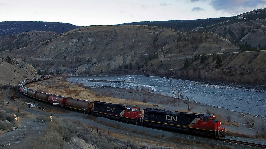 CN west bound loaded grain train on CN's Ashcroft Subdivision at Martel, on Thompson River above Spences Bridge - 3 January 2012 [photo © JST] CN west bound loaded grain train on CN's Ashcroft Subdivision at Martel, on Thompson River above Spences Bridge - 3 January 2012 [photo © JST] by Wett Coast, on Flickr The Thompson and Fraser canyons below Basque Junction are 'Directional Running Territory', where almost all west bound trains of both companies use the CN tracks, and east bound trains use the CP tracks. Another picture...  Rainy day freight Rainy day freight by Wett Coast, on Flickr CN west bound grain train on CN's main line bridge at Cisco in BC's Fraser Canyon - 4 January 2012 That is CP's main line at lower left of photo. The CP bridge over the Fraser is just visible on the left of photo. This view is from hillside near the connecting track between CN & CP. [photo © JST] |
|
|
|
Post by Low Light Mike on Jan 7, 2012 22:19:51 GMT -8
About 10 km east of Spences Bridge there is a road leading down to the Thompson River bank, and a point on the CN line called Martel. This is an excellent and safe point to view trains on the CN line coming around a series of curves similar to what you have on the CPR at Morant's Curve in Alberta. If you get close enough to the river you can look west along the CN right-of-way to signal lights that will help you to know if a west bound train is coming (i.e. the lights are green over red, or yellow over red; if red over red a train is not coming any time soon). There is also a reasonably good view here of the CP line on the other side of the river. Thanks for the tips Jim. For Cisco bridge photography, is that spot the safest and easiest for someone heading north on Hwy 1 ? |
|
|
|
Post by WettCoast on Jan 9, 2012 22:32:49 GMT -8
The road leading down to the Cisco bridges is sign-posted 'Cisco Station Road'. It is not difficult to access from Hwy #1 when northbound, but can easily be missed when heading south. This is about 10 km south of Lytton. Here are two more photos taken at this famous site at which you will find two of the most heavily used rail bridges in Canada... 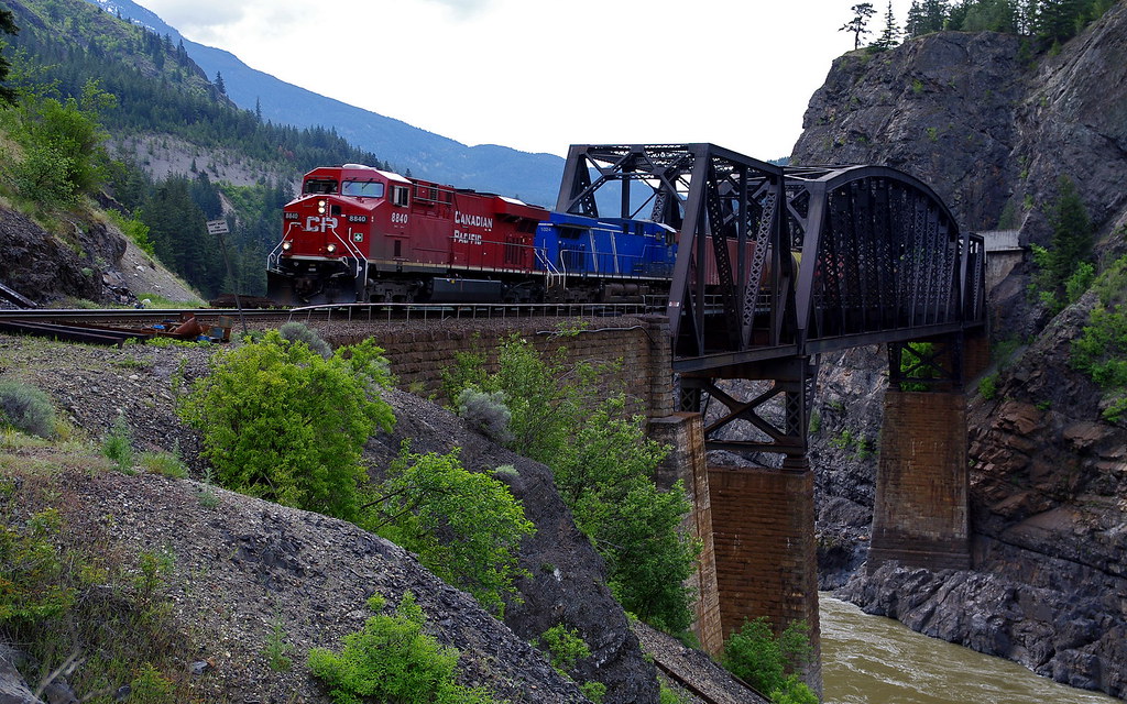 CP empty grain east bound on CP's bridge @ Cisco in Fraser Canyon - 8 May 2010 CP empty grain east bound on CP's bridge @ Cisco in Fraser Canyon - 8 May 2010 by Wett Coast, on Flickr The stone pillars supporting CP's bridge have been doing so since 1885, although the bridge itself is a little newer. 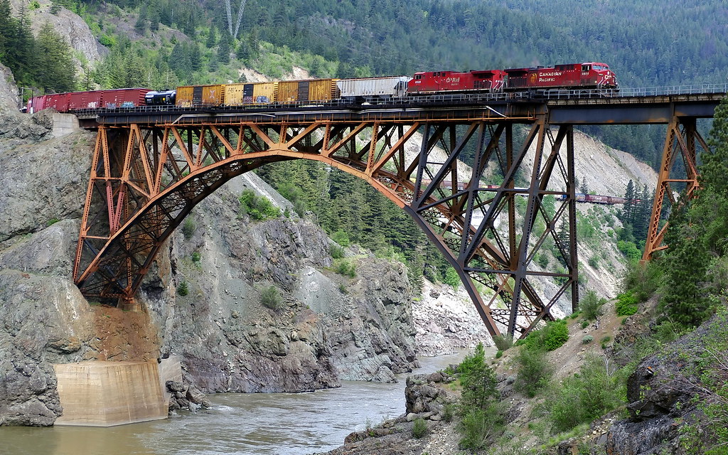 CP mixed freight west bound on CN's bridge @ Cisco in Fraser Canyon - 8 May 2010 [photo © JST] CP mixed freight west bound on CN's bridge @ Cisco in Fraser Canyon - 8 May 2010 [photo © JST] by Wett Coast, on Flickr I would love to be able to photograph two trains simultaneously at this site, one moving on each mainline. That would be 'sweet'. Be very aware that about 30 trains daily are moving over each line. They tend to come in bunches of nothing for several hours and then three to five trains with only 15 minutes between each other. Use your eyes & ears & be very careful - Any Time is Train Time! |
|
|
|
Post by lmtengs on Jan 9, 2012 22:48:39 GMT -8
|
|
|
|
Post by WettCoast on Feb 3, 2012 10:56:01 GMT -8
CP west bound double stack box train @ Morant's Curve - CPR Mainline (Laggon Subdivision, just east of Lake Louise - 15 August 2011 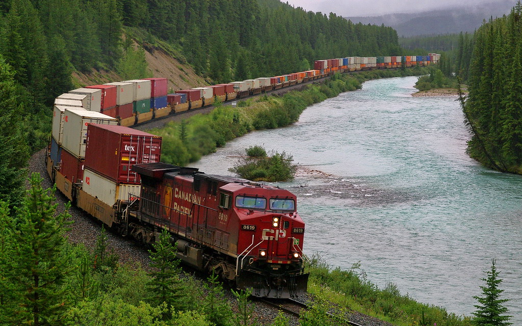 photo © JST photo © JST by Wett Coast, on Flickr[/size] That is the Bow River beside the tracks. This train, like most trains on CP's mainline west of Calgary, uses what is called DPU power; i.e. there are other power units (locomotives) elsewhere in the train consist. In this train there was one locomotive at about the half way point in the train, and a third unit closer to the tail end. Distributed power units are becoming more common on CN trains as well. DPU power is remotely controlled by the locomotive engineer located in the cab of the lead unit. |
|
|
|
Post by Low Light Mike on Feb 9, 2012 20:28:47 GMT -8
As part of my pre-trip reading, I bought Graeme Pole's book on Rogers Pass, "Gravity, Steam and Steel".
I already have his "Spiral Tunnels and Big Hill" book, so this Selkirks book should be just as informative.
For my interest in railway history, I'm particularly interested in the temporary areas of the line that have since been abandoned. ie.
- Rogers Pass loops
- the old stone bridge that is near the east-portal of the Connaught Tunnel
- the Big Hill
- OtterTail.
Those temporary solutions made for some fascinating history.
|
|
|
|
Post by WettCoast on Feb 9, 2012 21:35:32 GMT -8
Mr FH: You should also check out the remains of Glacier House, which was located just west of Rogers Pass. What started out as a 'dining station' turned fairly quickly into one of CP's famed mountain hotels like the BSH at Banff, and the Chateau at Lake Louise. To find Glacier House leave the Trans Canada Highway at the Illecillewaet camp ground turnoff. Drive through the campsite and up onto the abandoned pre 1916 rail grade, which is now a gravel road. The rail grade here forms a giant 'U' shape and was double tracked. Nearby you will also find the Alpine Club of Canada's (ACC) Arthur O Wheeler Hut. Besides railway & hotel history there is hiking here, most of it steep and somewhat brutal. There is a short & recommended 1 km loop trail that is almost flat called the 'Meeting of the Waters' trail. On it you will get a good look at this stone arch bridge, which carries the pre 1916 CP grade over the Illecillewaet River. Glacier House was bi-passed when the Connaught Tunnel went into operation. Accessing it after 1916 was less convenient. That along with the rapid receding of the Illecillewaet Glacier (that was the biggest attraction for Glacier House in the beginning) led to much reduced patronage. CP closed it down in the 1920's and dismantled the buildings in 1929. Today you can still see some of the foundations, as well a remnants of a fountain and gardens that were in front of the hotel. I might recommend some more reading on this topic: The Great Glacier and Its House by W. L. Putnam. Also, a short distance down the road toward Revelstoke, another recommended short hike is the Loop Brook Trail (1.6 km) which takes you around the famous 'loops' that permitted the railway to follow a reasonable 2% grade between Rogers Pass and the Illecillewaet valley to the west. www.pc.gc.ca/pn-np/bc/glacier/activ/~/media/pn-np/bc/glacier/pdf/a-i/Hiking_Glacier_NP_Eng.ashxPS: This is one book that I do not have a copy of - Graeme Pole's "Gravity, Steam and Steel". |
|
|
|
Post by lmtengs on Feb 9, 2012 21:42:53 GMT -8
Another spot to stop and get pictures might be around the Alexandria Suspension bridge. Cross the bridge to the far side, then you'll see a trail jut off to the right. It follows an old switchbacking road grade up to the train tracks about a minute's walk away. No trains came along when I was there, but they travel Northbound only along that stretch.  This is looking North. You could get into such a position that you might be able to get the long drop to the Fraser and a train in the same shot. Just get that bush/tree thing out of the way by moving or bending it back.  This spot is 2 or 3 telegraph poles North of where the path leads back down to the bridge. |
|
|
|
Post by Scott on Feb 11, 2012 22:03:38 GMT -8
If you get close enough to the river you can look west along the CN right-of-way to signal lights that will help you to know if a west bound train is coming (i.e. the lights are green over red, or yellow over red; if red over red a train is not coming any time soon). I've been wondering about these, because there are a couple sets of these signal lights near Burnaby Lake along Winston Street and again near where the tracks cross Piper Ave. What is the purpose of these lights? To show the oncoming train that the track is clear for them? I'm just wondering if I see a green over red, what direction should I expect a train to come? This morning, we were at the Piper Ave. crossing to watch the Amtrak train head into Vancouver, and the east facing light was showing green over red. But there was also a eastbound train just before we got there, so I'm not sure which one it was for. |
|
|
|
Post by lmtengs on Feb 11, 2012 23:48:00 GMT -8
If you get close enough to the river you can look west along the CN right-of-way to signal lights that will help you to know if a west bound train is coming (i.e. the lights are green over red, or yellow over red; if red over red a train is not coming any time soon). I've been wondering about these, because there are a couple sets of these signal lights near Burnaby Lake along Winston Street and again near where the tracks cross Piper Ave. What is the purpose of these lights? To show the oncoming train that the track is clear for them? I'm just wondering if I see a green over red, what direction should I expect a train to come? This morning, we were at the Piper Ave. crossing to watch the Amtrak train head into Vancouver, and the east facing light was showing green over red. But there was also a eastbound train just before we got there, so I'm not sure which one it was for. The signals aren't for telling what trains are coming in the opposite direction. They're like traffic lights for trains. Green on top with red underneath means Go, yellow up top with red underneath means slow, all red means stop, etc etc etc. Attached is an official CN Rail sheet given to all conductors and engineers in-training. My mother, who works for CNR, was cross-trained as a conductor for whenever a Conductors' strike occurs. The jagged lines around a light mean it's flashing, and the letters are signs attached to the pot. If a light is black, it's not functioning properly. If a post is bent over, it's broken. If a light is black or bent out of place, treat it as a 'stop NOW' signal, because there could be a train oncoming in the track you're on without you knowing. A 'clear' speed is essentially top speed for the train. A medium speed is no faster than 45 miles per hour. A limited speed is no faster than around 30 miles per hour. A slow speed is no faster than 15 miles per hour. A restricted speed is no faster than 5 miles per hour. A 'block' is a section of rail track, usually around a mile in length, but shorter in congested or complicated areas of track, and longer in long, strait, rural areas. There is a signal at the start of each block, indicating to the train crew what they need to do to keep the train safely operating. If there's a train coming in the opposite direction, it will signal the train to slow down, and over the radio they'll be told to butt into a siding so the other train can pass. If there's a slower train ahead of them, but heading in the same direction, and the following train gets too close, the block signals will change to a slower speed limit so the trains don't hit each other. There are many other signals for different situations too, and they are on the attached file. A couple signals are only used in Ontario on the GO Train, their version of the West Coast Express, but faster. Attachments:filename (788.08 KB)
|
|
|
|
Post by lmtengs on Feb 11, 2012 23:54:37 GMT -8
I just tried to open the file from the forum, but it said it was 'damaged and could not open'... if the above version doesn't work, try it again by using this link: Attachments:filename (788.08 KB)
|
|
|
|
Post by Northern Exploration on Feb 12, 2012 8:48:39 GMT -8
I have always wondered what the lights mean as I drive by the rail lines. Not sure I will remember though ;D. The lights are in series of three or four here and overhead the rails. As you drive in or out of downtown the main rail line into the city runs along the Gardiner Expressway and there are a minimum of three tracks, you can clearly see the lines and lights. If you are going 100k or even 120k the GO Train passes the cars. VIA Rail and AMTrak also use the corridor and the odd freight train. I think 45,000 people an hour in peak times use Union Station, the main station on the network. If I remember correctly, that is a train movement every 90 seconds but I could be wrong. There also is a Go Bus terminal beside it, a subway station below, and a street car line that also comes in below. Not Grand Central or Penn Station size but quite significant. I think 250,000 plus use GO Transit a day. During rush hours, 4 to 6 for example, if you stand in any of the underground malls/city linked by the PATH system of tunnels, the crowd heading to the station is unbelieveable and the sound of the womens high heels on the marble, granite or limestone, is like a giant herd of horses or cows being driven down a street. GO Transit (buses and rail) is now owned by Metrolinx that is overseeing regional transit, developing a regional smart pay card, and building new regional services. The individual cities still have their independant transit companies. The TTC (Toronto Transit Commission) being the largest. Metrolinx combines bus orders for example to bring commonality and lower costs. Transit here is interesting at the moment. We have electrification about to start on the main east/west rail line in the next few years to allow more trains, closer together, and faster service. We have a massive building campaign to speed up two lines out of the city by running some in a trench so crossing of lines are lessened. These two lines cross the main CP line in the city and with freight trains almost every 10 minutes or so, slowdowns are inenvitable currently. With the grade seperation things will speed up significantly. The airport express line will use the same line for part of the way. No longer will it be refurbished Budd Cars unfortunately, but new slick special trains that will only run on that service bought along with a California transit service. Unfortunately it is being branded as a first class service and pricing will be too high in my opinion to take a lot of cars off the road. It will be less than a airport limosine but not by enough. toronto.ctv.ca/servlet/an/local/CTVNews/20110218/metrolinx-buys-pearson-trains-110218/20110218?hub=TorontoNewHomeBut the biggest area of interest is the TTC. A beligerant mayor who ran on a bunch of issues, one of which being scrapping light rail and building subways, is fighting with a large group who wants more services cheaper than a few services expensively. The mayor cancelled the light rail plan that was in place (unilaterally without council approval yet) and was replacing one line with a shorter subway. Of course people prefer subways, but don't support massive tax increases to fund it. So the TTC Chair called the Mayors bluff and brought an urgent debate to council over the issue. The majority voted to continue with the previous plan and of course the province has agreed that council has the last say. BUT, the mayor had replaced all the TTC Commissioners with his people when he was elected, so the Chair could be in trouble. It is like a transit soap opera As the Turnstyle Turns. Montreal and Quebec have to be lauded (ignoring debt of course ) have to be lauded for consistantly and regularly expanding their Metro. Seems every few years another station or two is being added. Had the approach of ongoing and consistant expansion happened in more cities than transit wouldn't need these big programs that in the long run cost more money. Toronto has added subway over the years but not fast enough or consistantly enough. |
|
|
|
Post by WettCoast on Feb 12, 2012 10:45:22 GMT -8
Things to keep in mind about the railway signal lights... On single tracked lines, such as is most common in BC's mountainous terrain, the signal masts are usually located on the right hand side of the track. As mentioned by CV above, these signals are basically 'traffic lights' for trains. Signals facing to the east will be used by engine crew on west bound trains to govern their movement over the track sections ahead. On double tracked lines signals governing the left hand track are usually located to the left of the track, though some times these signals are on 'signal bridges' located directly above the track. This latter arrangement is most common on multi-tracked lines such as NE would see in the greater Toronto area. Double (and multi-tracked) lines are usually signalled such that trains can move in either direction on any of the tracks. It is most common for trains operating over double tracked lines to use the right hand track, but sometimes they will go on the left track, such as when over taking a slower train. What 'John H' refers to in Burnaby is on a long section of double track (perhaps triple track?), I believe. So you first have to determine which signals are for which tracks. You should be able to figure it out. Moving over to my example (on the previous page of this thread) of CN's main line at 'Martel' in the Thompson River Canyon between Spences Bridge and Ashcroft, BC: - This is in the Co-Production agreement area between CN & CP. Almost all west bound trains of both companies are moving west over CN's tracks while east bound trains move on CP's. - When you drive down from the Trans Canada Highway to the river you will come to the CN tracks and a CN sign post indicating that you are at Martel. This is a very busy bit of track having 30, perhaps more, trains daily, most of them long & heavy bulk freight trains. Warning - any time is train time, watch all family members like a hawk, and (for god's sake) remove your head phones. You need your eyes and ears working for you. If you look west along the track (down stream relative to the river) you will see a double aspect signal which may show lights as follows: 1- green over red - train can proceed into the section ahead at the normal rated speed for that train over that track. The train that these signals are for may be just around the corner to the east (you might be able to hear it coming), or, it may be half an hour before it arrives at this point. 2 - yellow over red - train can proceed at slow speed into the section ahead. This may mean that the train will have a stop signal (red lights) at a signal further west, or, more likely, there is a train ahead operating in the same direction. The distance between trains is too short to allow a 'clear signal' to be set. 3 - red over red - There are no west bound train movements going to occur at this time over this section of track. After some time (a few minutes or maybe a few hours) the lights might change to yellow or green over red). There might also be a train moving east bound over this track although almost all east bound traffic should be across the river on CP's tracks. Note that major maintenance or trouble (wash out, derailment, etc) putting one track out of action will result in bi-directional traffic moving over the other (not disrupted) route. 4 - both lights off - no train coming, in either direction (could also be that signals are not functional). 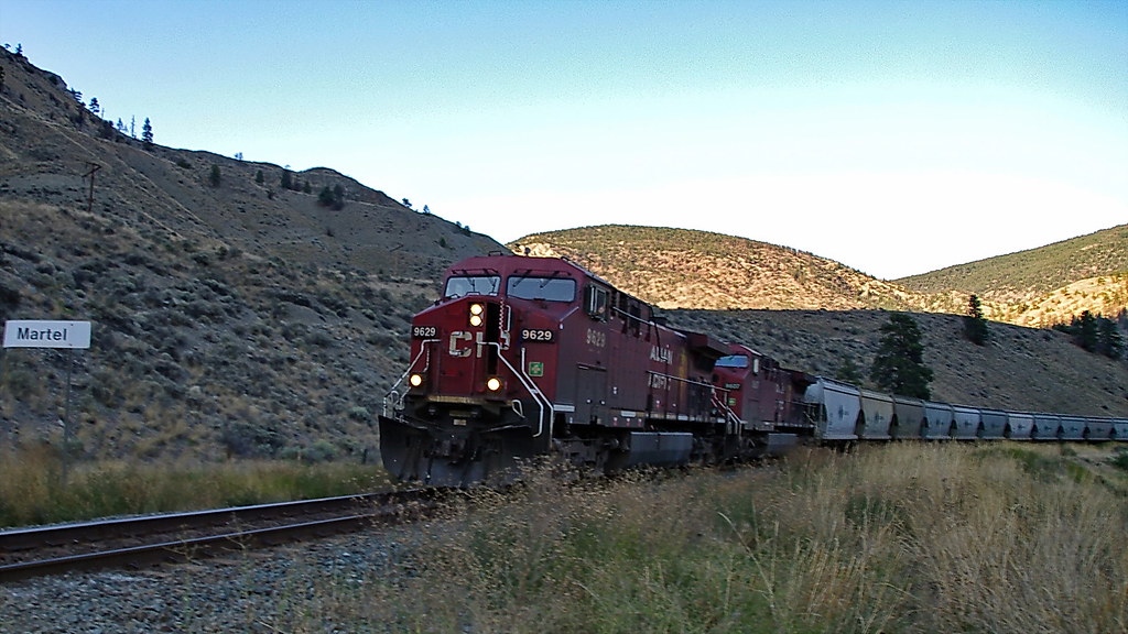 CP West Bound Potash Train on CN's Ashcroft Sub - Thompson River just above Spences Bridge - 9 September 2011 CP West Bound Potash Train on CN's Ashcroft Sub - Thompson River just above Spences Bridge - 9 September 2011
photo © JST by Wett Coast, on Flickr[/size] |
|
|
|
Post by Mike on Feb 12, 2012 11:37:58 GMT -8
Here is another link to what the various signal indications mean from the rulebook that all Canadian railways must follow, the Canadian Rail Operating Rules (CROR). Skip to #405 to see the various indications. www.tc.gc.ca/eng/railsafety/rules-tco93-175.htm |
|