|
|
Post by Low Light Mike on Feb 12, 2012 21:47:19 GMT -8
I'll borrow this thread for a passenger boat question: - has any done the boat cruise on Waterton Lake, on the old "International" 1920s passenger ship? I'm considering it for my vacation trip. Here's the website: www.watertoncruise.com/ |
|
|
|
Post by WettCoast on Feb 12, 2012 22:07:58 GMT -8
I was on one of those Waterton Lake boats many years ago. We (my wife & I) did the trip across the Lake to do the hike to Crypt Lake, which was billed as 'the best hike in Canada'. It was a fine hike, but nothing really special. There are many excellent hikes as good or better than Crypt Lake further north in the Canadian Rockies, Lake O'hara for instance. I can not remember anything notable about the boat ride on Waterton Lake. I don't think that I was on the older boat The International. I believe that I have some old photos... I assume that you and your better half would do the cruise taking you down across into Glacier Park, Montana. I hear that that is a good trip, though I expect its not cheap. Another renowned spot offering lake boat cruises in the Rockies is at Jasper's Maligne Lake. They take you down to what is called 'The Narrows', a truly sublime spot if you get the weather and conditions right. They also give you a speal in which they will tell you that Maligne Lake is the largest glacial carved & glacial fed lake in Canada which is simply not true. Maligne Lake & Spirit 'Island' - Jasper National Park, Alberta - 7 September 1987 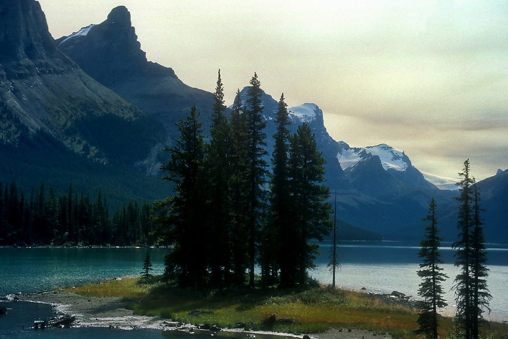 photo © JST - Konica slide - 87-09-19 - Nikon-VueScan photo © JST - Konica slide - 87-09-19 - Nikon-VueScan by Wett Coast, on Flickr[/size] |
|
|
|
Post by Low Light Mike on Feb 12, 2012 22:22:54 GMT -8
I assume that you and your better half would do the cruise taking you down across into Glacier Park, Montana. I hear that that is a good trip, though I expect its not cheap. Another renowned spot offering lake boat cruises in the Rockies is at Jasper's Maligne Lake. Thanks for the advice. Yes, we'd be doing the 2-hour cruise down into Glacier Park USA and return. I think it's $40 each for that. But this is still just in planning (which is a fun part of the trip process). I haven't done the Maligne Lake cruise yet. Some day.... |
|
|
|
Post by WettCoast on Feb 12, 2012 22:35:10 GMT -8
I am thinking that we did the trip to Crypt Lake in August of 1988. It was our honeymoon.
The international route should be worthwhile, I think.
|
|
|
|
Post by WettCoast on Feb 22, 2012 14:10:01 GMT -8
Head end of east bound CP freight @ Highway 1A Crossing near west end of siding at Stephen (Kicking Horse Pass) with Cathedral Mountain in background, Yoho National Park, BC - 21 September 1983 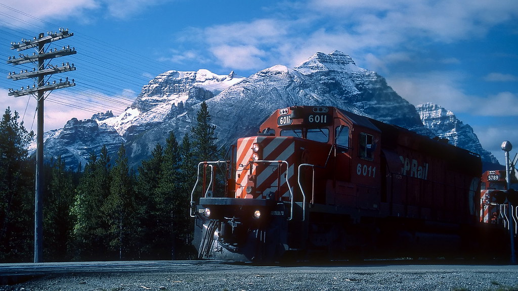 photo © JST - Kodachrome 83-13-23 - Nikon-VueScan photo © JST - Kodachrome 83-13-23 - Nikon-VueScan by Wett Coast, on Flickr[/size] Another recommended spot for train watching on CP's main line is at this place called 'Stephen', at Kicking Horse Pass, and the continental divide and boundary between BC & Alberta, & Banff & Yoho National Parks. The place to drive to is just off the Trans Canada on the old highway, once known as the 1A. I am unsure if they allow you to drive this road though I do know that it is open to cycling. In any case, you can park at the Lake O'hara parking lot and then walk to the divide. I recall that the distance is fairly short (~500 metres). There is (or was) an impressive wooden arch over the old highway, right at the pass. There is also a small creek called Divide Creek whose waters 'go both ways'. The railway is in the valley between the present Trans Canada Highway and the old 1A. It has several long storage tracks in addition to a long passing siding. The east end of the yard connects with the old mainline running down to Lake Louise which is used today mostly by eastbound descending trains. The east end also connects to the newer 'Second Mainline'* which also runs from Lake Louise. The west end of the yard connects to tracks dropping gently (at first) toward Field, BC. A few km west of this point the gentle drop is replaced by a steep drop (by mainline railway standards). I am of course referring to the Big Hill and the Spiral Tunnels. Chances are fair to good of seeing one or more trains at Stephen, and even if you don`t, the history and geography around you will inspire! You will also find several markers at the divide that commemorate historic events. One is for Dr. James Hector, the man in charge of the Rocky Mountains reconnaissance for the Palliser Expedition. He was the unfortunate guy who very near this spot was kicked into a state of unconsciousness by a spooked pack horse. Hence the name Kicking Horse Pass. *This 'Second Mainline' was constructed in the 1980's on a longer max 1% grade and is used by heavy west bound trains. It was built along with three other 'Second Mainline' revisions (elsewhere in BC; includes the Macdonald Tunnel route in the Selkirk Mountains to the west) that eliminated uphill grades exceeding 1%. |
|
|
|
Post by Low Light Mike on Feb 22, 2012 14:38:48 GMT -8
You will also find several markers at the divide that commemorate historic events. One is for Dr. James Hector, the man in charge of the Rocky Mountains reconnaissance for the Palliser Expedition. He was the unfortunate guy who very near this spot was kicked into a state of unconsciousness by a spooked pack horse. Hence the name Kicking Horse Pass. *This 'Second Mainline' was constructed in the 1980's on a longer max 1% grade and is used by heavy west bound trains. It was built along with three other 'Second Mainline' revisions (elsewhere in BC; includes the Macdonald Tunnel route in the Selkirk Mountains to the west) that eliminated uphill grades exceeding 1%. Thanks for that photo and for the directions to Stephen siding. I'll have lots of time to explore that area near the divide, so it will be fun. I think that this might be the area where Nick Morant and Mr. Haesler had a run-in with a grizzly-bear, in the 1920s. -------------------- Re Mr. Hector: - In my Graeme Pole book on Rogers Pass, it has a photo of an elderly Mr. Hector and Edward Wymper (Matterhorn fame), together at the funeral for Mr. Hector's son in Revelstoke. Hector & Son (then living in New Zealand) had visited Glacier House in the early 1900s to see the some of the end-results of Mr. Hector's 1850s work in the Canadian west. The son became sick (appendicitis) and died at Revelstoke hospital. ps: that photo in Mr. Pole's book was taken by Mary Shaffer, a famous Banff mountain photographer and pioneer. --------------- Re the 2nd Mainline construction in BC in the 1980s: - I think that the Notch Hill horseshoe in Tappen BC (Shuswap) was part of that overall plan. Thanks again Jim. |
|
|
|
Post by WettCoast on Feb 22, 2012 18:32:09 GMT -8
FH said: That attack took place in the valley above Sherbrooke Lake, about 5 km away from Kicking Horse Pass. The attack occurred in September of 1939. FH said: Mary Shaffer was a very interesting character in the early years of exploration & travel in the Canadian Rockies. She wrote a book which was reprinted under the title A Hunter of Peace. It is a very much recommended read and your better half might enjoy it also. It has virtually nothing in it about the railways, though. FH said: Yes, that is correct. The fourth site is just west of Revelstoke and was called the Clanwilliam Second Mainline. The CP mainline across BC has several areas with grades exceeding 1%. All such areas with ascending grades for west bound trains now have second tracks on gentler grades of 1% or less. There remain several locations with long sections of 2+% grades that east bound trains must climb, and west bounds must carefully descend. By contrast, CN's two routes across BC (the one time Canadian Northern Pacific & the Grand Trunk Pacific) never ever had any grades exceeding 1%. In this day and age that is a considerable advantage for CN. I spent some time in September of 1983 checking out CP's route through the Kicking Horse & Rogers Passes. One of the places that I went (hiked) to was the Stoney Creek bridge on the eastern approach to the Connaught Tunnel. The grade at that point is 2.4% ascending for west bound trains. I saw a coal train there en route from Sparwood to Roberts Bank. It had a total of 12 - 3000 horsepower locomotives in the train (3 at the front, 4 unmanned helpers in mid train, and finally, a manned 5 locomotive pusher service cut in near the end of the train to assist it up the steepest part of the grade. All this at an impressive speed of 15 miles per hour. Just west of the Stoney Creek bridge the pushers had to be cut out, and then they would run back downhill 'light' to a place called 'Rogers', where they would wait for their next assignment. A similarly long heavy train today would have just 3 - 4400 HP locomotives, one or two at the head end and one or two remote controlled further back in the train. The trains run at twice the speed, and of course they would be using the much less steep Macdonald Tunnel route. The pusher service is long gone.
CP west bound unit coal train heading up grade just west of the Stoney Creek Bridge, Mountain Subdivision, east of Rogers Pass, Glacier National Park, BC - 15 September 1981 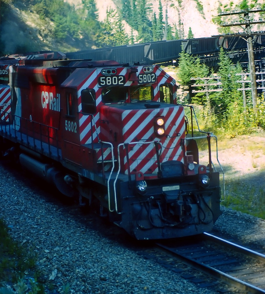 photo © JST - Fujichrome 81-16-30 - Nikon-VueScan photo © JST - Fujichrome 81-16-30 - Nikon-VueScan by Wett Coast, on Flickr[/size]
|
|
|
|
Post by Low Light Mike on Feb 22, 2012 18:48:15 GMT -8
I spent some time in September of 1983 checking out CP's route through the Kicking Horse & Rogers Passes. One of the places that I went (hiked) to was the Stoney Creek bridge on the eastern approach to the Connaught Tunnel. The grade at that point is 2.4% ascending for west bound trains. I saw a coal train there en route from Sparwood to Roberts Bank. It had a total of 12 - 3000 horsepower locomotives in the train (3 at the front, 4 unmanned helpers in mid train, and finally, a manned 5 locomotive pusher service cut in near the end of the train to assist it up the steepest part of the grade. All this at an impressive speed of 15 miles per hour. Just west of the Stoney Creek bridge the pushers had to be cut out, and then they would run back downhill 'light' to a place called 'Rogers', where they would weight for their next assignment. A similarly long heavy train today would have just 3 - 4400 HP locomotives, one or two at the head end and one or two remote controlled further back in the train. The trains run at twice the speed, and of course they would be using the much less steep Macdonald Tunnel route. The pusher service is long gone. A YouTube video of this 1980s "now ancient history" |
|
|
|
Post by Low Light Mike on Feb 22, 2012 18:58:20 GMT -8
FH said: Mary Schaffer was a very interesting character in the early years of exploration & travel in the Canadian Rockies. She wrote a book which was reprinted under the title A Hunter of Peace. It is a very much recommended read and your better half might enjoy it also. It has virtually nothing in it about the railways, though. We own the book "No ordinary woman", a biography on Ms. Schaffer. www.hgdistribution.com/book_details.php?isbn_upc=9780921102823- and you're right. Mrs. Horn has read our Shaffer book, but I haven't yet. Thanks for the note on Mary's own book. |
|
|
|
Post by WettCoast on Feb 25, 2012 21:31:56 GMT -8
CPR mainline @ Cathedral, Laggan Subdivision between upper & lower Spiral Tunnels in Yoho NP, BC - 21 September 1983 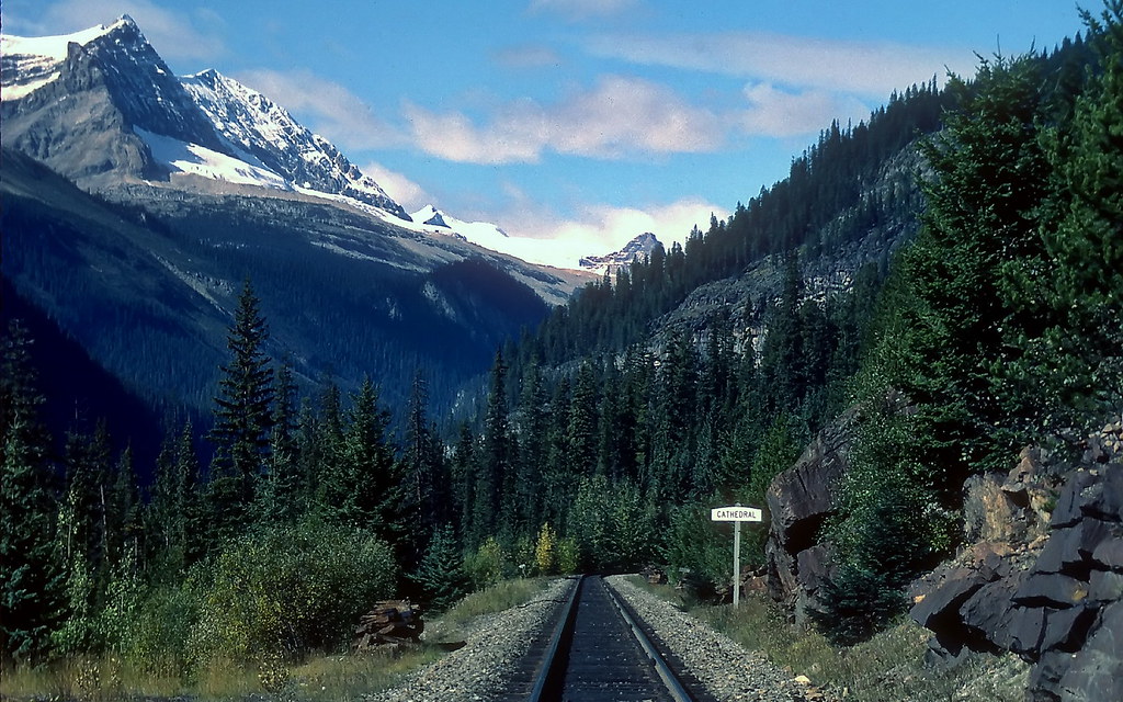 photo © JST - Kodachrome 83-13-30 - Nikon-VueScan photo © JST - Kodachrome 83-13-30 - Nikon-VueScan by Wett Coast, on Flickr[/size] There was a railway scene in the movie Dr. Zhivago that was filmed in this location looking up the Yoho River valley. This scene was doubling for the Ural Mountains in Russia. Many sources state that parts of Dr. Zhivago were filmed in Alberta, but this scene was most definitely in British Columbia. |
|
|
|
Post by Low Light Mike on May 21, 2012 18:35:16 GMT -8
The trip ideas keep getting more interesting for me. Today's questions are:
1) Has anyone here driven the "Going to the Sun Road" through Montana's Glacier National Park?
- I'm thinking this would be a good addition to my driving trip.
2) The Kootenay Lake ferries:
- I plan on taking a few trips on the Balfour and Osprey-2000. But I also want to do some shore shots, maybe even of the 2 ships passing.
- Does anyone know of some good spots around Balfour? From Google-maps, I can see what looks like a public beach right at the point where the west-arm joins the main part of Kootenay Lake.
The good thing about my plan for my trip, is that I have a few "stay in one place for 2 days" moments, and so I can take advantage of dawn and dusk times for photography.........or at least get a photo of the Balfour ferry when the sun isn't behind the ship. ;D
|
|
|
|
Post by Mike on May 21, 2012 19:14:29 GMT -8
The trip ideas keep getting more interesting for me. Today's questions are: 1) Has anyone here driven the "Going to the Sun Road" through Montana's Glacier National Park? - I'm thinking this would be a good addition to my driving trip. My dad and I drove it in 2006. I would definitely recommend it. Here are a couple photos from the trip.   Another place I would recommend visiting, that is in the same area, is the Hungry Horse Dam. It makes the Revelstoke Dam look small. ;D  |
|
|
|
Post by Low Light Mike on May 21, 2012 19:30:58 GMT -8
My dad and I drove it in 2006. I would definitely recommend it. Here are a couple photos from the trip. Another place I would recommend visiting, that is in the same area, is the Hungry Horse Dam. It makes the Revelstoke Dam look small. ;D Thanks for that advice. much appreciated (the photos too) |
|
|
|
Post by WettCoast on May 21, 2012 20:58:26 GMT -8
My wife & I did the 'Going to the Sun' road in Glacier Park, Montana, as part of our honeymoon trip in 1988. It was well worthwhile & I would do it again. While you are in that general area you are close to the BNSF mainline through Marias Pass. This is the line built by JJ Hill & the Great Northern Railway. There is a lot of history & great train viewing there, just like there is further north along the CP main line. www.railroads-of-montana.com/marias_pass_railfans_guide.htmI don't know about Kootenay Lake ferry watching vantage points though I would be surprised if you can't access some good spots. My brother may have some ideas about that as he has spent a lot of time there in summers over the last 10 years. Do keep in mind that the Balfour operates on somewhat limited hours in the summer, and not at all during most of the rest of the year. I believe its day starts at about 9 AM and goes to about 7 PM. Service before & after those times is with the Osprey 2000 only. Dawn shots of the Balfour can be had only at its tie-up location at the Balfour terminal. |
|
|
|
Post by Low Light Mike on May 22, 2012 12:07:03 GMT -8
Note to self (and others) re Kootenay Lake ferry-spotting:
- McEwan Point, in the Queen's Bay neighbourhood, north of Balfour. Near Hamilton Drive.
Looks to be a good spot on the west side of the lake for viewing up to Kootenay Bay and down to the West-Arm junction.
|
|
|
|
Post by Low Light Mike on Jul 21, 2012 17:21:57 GMT -8
I recently completed a 13 day road-trip with my wife. The followings posts are a day-by-day report on what we saw and my thoughts on travelling through these parts of North America. Relevant photos are being posted in the various specific forum threads that these relate to (ie. ships, trains, bridges, etc). ======================== Day 1 (We can have lots of fun): - Nanaimo to Kamloops BC. We chose Kamloops because our eventual destination (booked since last December) was a cabin at Yoho National Park. So we needed to be on the TransCanada Highway. Also, we wanted to visit the Canadian Wildlife Park at Kamloops, and this meant that we'd visit it for the morning after our night in Kamloops. My interest in railways means that we'd be travelling the Hwy-1 Fraser Canyon route. I enhanced it a bit by crossing the Fraser at Rosedale/Agassiz on that bridge, so that I could see the CPR main line on the north shore of the Fraser near Ruby Creek. We chose to leave on the first Route-2 ferry of the day; which was 6:20am from Departure Bay. - 5:15am from Duke Point was too early for us, and the 7:45am from Duke Point would have been too late, regarding where and when we wanted to end up at the end of our driving date. So we settled on 6:20am on the Coastal Renaissance, and taking the "new" ship was part of our choice. We left on a Sunday morning, and did not make a reservation. I figured that the sailing would be less-than-full because of the early day time. We were correct, it was only maybe 75% full or a bit less. We arrived at the terminal at 5:50am, a half-hour before sailing, and that was fine. My wife is not a morning-person (well, not that early), and so we manage this by just letting each of us be ourselves. So she spent most of the sailing time in the car, sleeping. I spent most of the sailing outside on the decks, gazing at the water and taking photos. It was a hazy morning, and this haze stayed with us all the way to Cache Creek BC. It turned out to be smoke from Russian forest fires (thank you, Claire Martin of CBC, for that info). On the sailing, I saw the following ships: Queen of Alberni, Queen of Oak Bay, and Queen of Capilano. I had not driven the Hwy-1 through Greater Vancouver for a few years, so this was an education for me. I noted the Boundary Rd. interchange closure, and was keen to see the new Port Mann bridge construction. The game of lane-changing for moving-over for merging traffic and dodging slow-moving vehicles quickly became tiresome. Not for me. I was glad to exit the freeway at Rosedale. We stopped at Alexandra Bridge park, but just stayed near the washrooms; no bridge trail for me that day, because I'd already seen it and had enjoyed other people's fine photos of it. I had a glancing drive-by view of the rail bridges near Cisco BC, but again didn't stop. Instead, we stopped in a few places at Lytton BC, before noon (before it got really really hot). - Using Google-maps the day before, I found the CN rail/pedestrian bridge over the combined river. I also noted the CN rail bridge over the Thompson. We found both and enjoyed both. The CN pedestrian/rail bridge was fun for me walking across, with the metal grate deck. A bit freaky, but a fun kind of freaky. There was lots of foot traffic, probably because the reaction-ferry was out of service. - sadly, no train passed when I was on/near the bridge. When we arrived at the CN Thompson bridge (beside the Lytton Hwy-12 road bridge), I saw a coal-train stopped before the bridge, so I was anticipating a sighting, but did not know how long until the train started up. - finally, I heard the sound ("hearing" the train coming, before you "see" it, became a skill that I got used to during this trip, at various locations). I enjoyed the train passing below me, and was a bit conflicted about seeing all that Crowsnest coal destined to pollute Asia. Ah, the resource extraction, consuption, pollution dilemma. My wife was out and about, and used her perspective and interest to find an osprey nest that I had completely ignored. So we both enjoyed watching and photographing the Osprey mom and her 2 fledglings. When we passed Spences Bridge, we had our first " Glance at something while driving by, think about it for a few hundred metres, then turn-around and go back to take some photos" moment. It was a waterfall, just south of the town.  A few moments later, we had a meaningful train encounter: - As we were driving north along the Thompson River canyon area, we saw a train heading south (towards us) on the CN track. We first realized that it was a passenger train. We then realized that it was an antique passenger train. - We found a pull-out area off the highway and managed to snap a few photos of the CPR Royal Canadian Pacific train as it disappeared around a corner. After that, it was lunch (Subway from Cache Creek, enjoyed a few miles down the road overlooking the Thompson River near Savona). Kamloops night stay was at the Holiday Inn Express (next to Costco and Rona, on the highway above town). We liked it; it was clean, comfortable and the room was large enough that we didn't feel closed-in. I've stayed there before, and I would stay there again. (end of day 1) |
|
|
|
Post by Low Light Mike on Jul 28, 2012 11:39:49 GMT -8
Trip report: Day 2 (there's so much we can do)
Start of day: Kamloops BC
End of day: Revelstoke BC
We had planned a short driving day, because the morning would be taken-up by a visit the zoo at Kamloops. The zoo is a Canadian Wildlife Park, and had animals such as elk, bear, wolves, llamas, raptors, bison, moose, etc. And the zoo has a train, which had a fairly steep grade.
- We enjoyed our 2.5 hours at the zoo, but it was already a very hot morning.
After the zoo, we headed east on Hwy 1, passing Pritchard and other places along the highway, where the CPR track and long-trains were our regular neighbours.
I had planned to stop at Notch Hill to see the field-loop diversion, but I overshot the turn-off, realized that I'd missed it, found a U-turn route, and backtracked to get onto Notch Hill Rd. We arrived just as a coal-train was working it's way up the loop hill.
- photos and video of this are posted in the trains thread.
We picked up lunch in Salmon Arm (thank you, Dave Thomas), and stopped to eat it in Sicamous. I saw the CPR swing-bridge at Sicamous as we came into town, but I couldn't find a good place to pull-over and photograph it. We tried, but a place by the lakefront turned out to be flooded, from the recent high-water event.
- while trying to get back onto the highway, we were delayed by a long-train passing. We shut off the engine and enjoyed watching the train go by.
Next stop was Cragellachie, site of the CPR last-spike. Probably more known now as just another highway rest-stop.
- I took some photos and bought a few books at the gift shop (run by the Revelstoke Train Museum).
After that, there was some highway construction near Clanwilliam hill, and then we made it into Revelstoke around 3:30pm.
- Our motel was the Swiss Chalet Motel, just down the street from the Railway Museum. It was simple and clean, and allowed us to hear trains all night long.
The Revelstoke Railway Museum was a good visit. We were the only guests there, and enjoyed the freedom of the place. An "old steam guy" was in the locomotive, and so we chatted for a bit, me realizing my huge lack of knowledge of mechanics.
While we were there, a thunderstorm started, and we walked back to the motel in the rain (felt nice, after a hot day).
Later when the rain stopped, we drove around town a bit, and I had fun driving the one-lane bridge across the Columbia River. I also scouted some photo locations for next-morning at the bridges.
And that was day-2. Animals, trains and thunder. Oh my!
|
|
|
|
Post by Low Light Mike on Jul 30, 2012 19:36:59 GMT -8
Day 3:
Start: Revelstoke BC
End: Cathedral Mountain Lodge, Yoho National Park.
-----------------
A short driving day, similar to the day before, with lots of stops.
My day started with a sunrise photo session on the Columbia River highway bridge, enjoying the morning light reflections and eventually seeing a coal train crossing the river. That was a very fun and peaceful time.
Breakfast was one of those waffle-machines in hotel breakfast rooms, with the dough coming out of a machine, and the line-up to use the waffle iron. But it was good.
We barely saw Mt. Revelstoke National Park, but it was technically our first National Park of our trip. Some day, I need to take the scenic road that goes up the mountain.
Once inside Glacier National Park, we were in "railway mode", looking for history. We saw the west portal for the 1988 Mt. MacDonald tunnel, but didn't stop (I'd seen and photographed it before).
We were driving towards the jagged peak of Mt. Sir Donald, looking for the Loop Brook campground sign. We found it, and stopped for our first outing of the day; a 3 km hike on the old 1885 grade that included the old stone pillars of 2 bridges. Very cool to see.
Next time, I would like to also take the trail that connects to the next campground, near Glacier House.
Our next stop was at the Rogers Pass Discovery Centre, a favourite place for us to visit. We bought our annual Parks Canada Discovery Passes here, and then enjoyed the centre's railway displays and the "Friends of Glacier Park" gift shop. Mrs. Horn was happy to get a last year's Parks Canada 100th Anniversary shirt on sale for $5.
Then it was the highway again for us, as we travelled east of Rogers Pass, looking for that elusive stone-arch railway bridge on a distant hill. We never found it, but we did spot a coal train and were able to see the 2 CPR grades on the hill (one low, and one high).
In Golden, we stopped for groceries, and enjoyed lunch on the banks of the Kicking Horse River beside the wood-truss pedestrian bridge. That's another favourite spot of ours.
Back onto the highway, and we had early afternoon heat and heavy traffic as we drove the Kicking Horse Canyon section of Hwy-1; not the best road in Canada, until we got to the new Park Bridge section. I saw a rest-stop pull-out just west of the Park Bridge, which would have had a good photo angle, but we didn't stop. I regret that a bit.
- During our trip, I learned that I can't stop at every single place that interests me. I needed to leave some places for another time. I had another such "drive by" experience later in our trip, when we didn't stop at a museum (with a CPR boxcar or caboose), somewhere on the KVR line, probably at Greenwood BC. But those are for a future trip....
We stopped at the Parks Canada visitors centre at Field BC, with another "Friends" store to buy postcard souvenirs at. Then it was off to our cabin, at Cathedral Mountain Lodge.
- When we arrived and checked-in, we that satisfied feeling of realizing that we'd made a great choice (way back in December, when I had booked it). A nice higher-end cabin resort with exceptional service.
And we were just where we wanted to be for a 3-night stay. A 30 minute drive to Lake Louise, a 10 minute drive to Emerald Lake, and a 2 minute walk to a view of Mt. Stephen and the CPR nose tunnel.
That evening, we enjoyed the evening-sun views of Mt. Stephen, saw a train going through the nose tunnel, and then later I planned my next morning's early adventure trip to Morant's Curve.
A fine day...
|
|
|
|
Post by Kahloke on Jul 30, 2012 19:39:49 GMT -8
Great trip reports, Flug! Thanks for sharing. It looks like it was a really fun vacation.
|
|
|
|
Post by lmtengs on Jul 30, 2012 22:18:16 GMT -8
Back onto the highway, and we had early afternoon heat and heavy traffic as we drove the Kicking Horse Canyon section of Hwy-1; not the best road in Canada, until we got to the new Park Bridge section. I saw a rest-stop pull-out just west of the Park Bridge, which would have had a good photo angle, but we didn't stop. I regret that a bit. I believe you can still drive the old route of the Trans-Canada, right beneath the Park Bridge and through to the old highway bridge. The West side access is right at that rest stop, and I'm not sure about East side access. There are a few intersections East of the new bridge, you'd have to try each one out. You'd get some good photos of the Park Bridge from that old highway alignment. I'm not sure if the old Highway One bridge is still there, or if they removed it. Were you able to check that out? If it's still there, you'd get some great pictures of the old bridge too, not from the Park Bridge (no sidewalks), but from the old highway grade which should lead right up to the old bridge, or what's left of it. |
|
|
|
Post by Low Light Mike on Jul 31, 2012 6:30:46 GMT -8
Back onto the highway, and we had early afternoon heat and heavy traffic as we drove the Kicking Horse Canyon section of Hwy-1; not the best road in Canada, until we got to the new Park Bridge section. I saw a rest-stop pull-out just west of the Park Bridge, which would have had a good photo angle, but we didn't stop. I regret that a bit. I believe you can still drive the old route of the Trans-Canada, right beneath the Park Bridge and through to the old highway bridge. The West side access is right at that rest stop, and I'm not sure about East side access. There are a few intersections East of the new bridge, you'd have to try each one out. You'd get some good photos of the Park Bridge from that old highway alignment. I'm not sure if the old Highway One bridge is still there, or if they removed it. Were you able to check that out? If it's still there, you'd get some great pictures of the old bridge too, not from the Park Bridge (no sidewalks), but from the old highway grade which should lead right up to the old bridge, or what's left of it. Thanks for that. I wasn't able to see if the old highway bridge is still there. This is what I like about this forum, that these kinds of travel advice can get shared, and a few years from now, people will still be able to use these trip-tips as a resource. As for the Park Bridge, I'd love to explore that area in better depth (instead of just driving over it, like I did). - some day.... |
|
|
|
Post by Low Light Mike on Aug 9, 2012 18:02:58 GMT -8
Day 4:
Start & End: Cathedral Mountain Lodge, Yoho National Park.
==================
This was a fun day, filled with "take advantage of the location" activities.
It started for me at 4:50am wake-up, and a 30-minute drive into Alberta to Morant's Curve. I used my sweatshirt and toque for that morning, a cool one.
It was amusing to see that on Hwy-1 the twinning-construction started right at the Alberta Border and continued to Lake Louise.
It was nice travelling so early in the morning in the quiet mountains. I took my exit at Lake Louise and found my way to Hwy-1A and then it was just a few KM down the road until I arrived at the Outlet Creek rest-stop, better known as Morant's Curve.
I enjoyed over an hour at the curve, by myself. I had the door open in case of a chance wildlife encounter (I was paranoid about bears, in the early morning), but no such encounters happened.
I enjoyed the sunrise effect on the mountain peaks and then seeing the "sunline" creep down the mountains, but the valley bottom and track stayed in the shadows.
I saw 2 trains at the curve: One westbound, and then an eastbound one. Good times!
After packing up from Morant's Curve, I drove back into BC and stopped at the CPR "Old Bridge" pullout. I like that old big-hill relic.
Then it was back to my driveway (Yoho Valley Rd.), but I decided to drive part way up the hill towards Takkakaw Falls, to find the Upper Spiral Tunnel viewpoint.
- I found it, just before a train went through the tunnel. So I enjoyed watching and photographing a train transit through the tunnel, in the quiet morning.
.....then back to the cabin at the lodge, to find my wife just starting her day. ;D
I had my lodge free-breakfast (pretty good, better than at the Holiday Inn Express, haha).
Then we (yes, we did some stuff together) were off to Emerald Lake, which was just a few minutes away. We arrived before the hordes of tourists, and easily found parking. We did the lake circuit walk, and took lots of time to stop and photograph stuff and to enjoy being in such a beautiful place.
- the back-end of the lake is slowly (over a few hundred years) being filled-in by the sediment from stream run-off. Speaking of the streams, we had numerous swollen streams to ford on the trail. A few bridges, a few boards-and-rocks, and a few running leaps.
When we finished our walk and arrived back near the Emerald Lake Lodge, we found it much busier than when we had started. The tour buses had arrived and the parking lot was overflowing.
On our way down the road back to the highway, we passed the Natural-Bridge attraction, but didn't stop. It didn't seem too spectacular (although we don't really know, because we didn't stop), and we were a bit tired........or at least I was, after my early morning.
We enjoyed an afternoon break at the cabin, and then in the evening we drove back into Alberta to enjoy Lake Louise in the evening. It was nice driving up the hill to Lake Louise while hordes of tourists were driving away down the hill. We easily found parking and walked along the side of the lake, part way down the length. We enjoyed evening photography of the lake and mountains.
Then, after the lake, we stopped by Morant's Curve for a sunset view. Twice in one day, I got my fill of the curve. However, we didn't see a train on this evening visit.
....and then back to the cabin by 9:00pm. A very long and fun day for me, and my wife enjoyed it too.
|
|
|
|
Post by Low Light Mike on Aug 14, 2012 18:58:36 GMT -8
Day 5: Start & End: Cathedral Mountain Lodge, Yoho National Park. ================== Our 2nd full day at a nice cabin resort in Yoho Park. I slept-in until 6:30am, and then left after breakfast for a solo trip just a few km up the road, in search of Cathedral siding, and the scene from the Dr. Zhivago movie (see WCK photo earlier in this thread). - I parked my car on the side of the highway, just west of the bridge crossing over the CPR track, for the line that ascends from Field to the lower spiral tunnel. - I found an old overgrown roadway and climbed up a steep path, ending up at what appeared to be a rail service road. After walking 50 metres or so, I found a sign for an interpretive trail and the famous locomotive-in-the-woods from the tunnel construction days. I had stumbled upon the "Walk in the Past" trail, and I then found the spot for the old safety-spur #3. I climbed around a bit on some slopes, looking to see if I could find Partridge and the upper spiral tunnel, but I gave up, and walked back down to my car. Then it was only a short drive further up the highway to the viewpoint for the Lower Spiral Tunnel, and I got there around 9:00am. - I had fun at the viewpoint because a train came through, and I enjoyed explaining the tunnel to some fellow tourists. After this train show, I headed back down to our cabin and spent the rest of the morning sitting in an Adirondack chair beside the Kicking Horse River, looking up at Mt. Stephen and its 1884 nose tunnel. And when I looked up at the hills, I knew from wence commeth my help.... Later on in the day, we drove up the Yoho Valley Rd. to Takakkaw Falls, just in time for a rain storm. And it was a cold rain, at that high elevation. It was fun watching the tourists run around in the rain, just like we were doing. - after that, we drove back down the road and stopped at the Upper Spiral Tunnel viewpoint, where I was again treated to a train transiting the tunnel. And the rain had stopped.... For the evening, I spent an hour or so just staring up at the mountains, enjoying the spiritual aspect of being in such a beautiful place, for our last evening there. Meanwhile, my wife was looking for wildlife and took this photo: 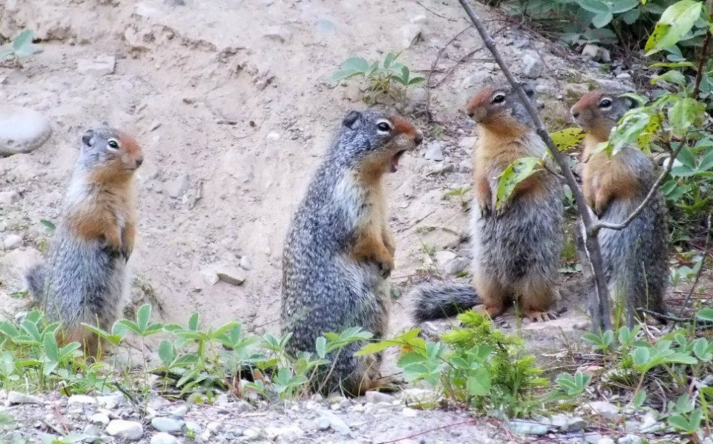 The next day would be a travel day, but not too far...just to Banff, ending at Canmore. |
|
|
|
Post by Low Light Mike on Aug 21, 2012 12:09:35 GMT -8
Day 6:
Start: Cathedral Mountain Lodge, Yoho National Park.
End: Canmore AB
==================
This was a Friday, and the morning was our sad good-bye to a very nice cabin resort in the Rockies. I would go there again, and my advice to others is to plan well ahead and book early in order to get a good rate-discount (we booked our July vacation in early January).
We had a short day of travel, but spent lots of time stopping and enjoying the mountain scenery.
- We stopped at Lake Louise village so that I could take a few more photographs of the train station there.
- We stopped at Morant's Curve again, my 3rd time there. We waited for over an hour, but did not see a train. I was doing my "Just 5 more minutes, please" pleading with my wife.
- We took Hwy 1A between Lake Louise and Banff, and enjoyed the slower pace. We saw lots of cyclists on that route.
- We stopped at a memorial near Castle Mountain, to Canadians who were held there at an internment camp during the Great War. This was for Canadians of Ukrainian and Austro-Hungarian heritage, similar to how we treated Japanese-Canadians during WWII.
We spent a couple of hours at Banff town. Parking was hard to find and we ended up on a streetside a few blocks away from downtown. The walk was nice.
We visited the visitors centre (where there is a small "Friends of Banff Park" store), and then enjoyed the Whyte Museum and the Banff Park Museum.
- The Whyte Museum of the Canadian Rockies had lots of beautiful paintings in a temporary exhibit of the Rocky Mountain corridor of "Yukon to Yellowstone". We also enjoyed their small Nicholas Morant exhibit.
- The Park Museum is a 100 year old wood building with lots of century-old dead animals (taxidermy displays). It gives a glimpse of what the park office looked like 100 years ago.
The Bow River was really high because of seasonal melt, but we still were able to walk on a nice park walkway down beside the river, and then back on the swank Buffalo Ave with some really nice houses and yards.
Then I found the train station in Banff, but it was a disappointment in that it was old (yes they are all old) but not particularly appealing to me. Run down and tired looking, and not really being used.
- The Lake Louise station (now a restaurant) was more appealing.
We ended our day in Canmore, at a simple motor inn. While driving around town looking for a fuel-station, I was stopped at the train tracks for a passing train which turned out to be the Royal Canadian Pacific heritage train.
- Darn it, I missed another photo opportunity, but I realized that I can't be everywhere at once and I wasn't going to be able to photograph everything. ....so I didn't chase the train to Exshaw, haha.
An early night to sleep, because I needed to be up early the next morning to photograph the 3-sisters mountains at sunrise.
|
|
|
|
Post by Low Light Mike on Aug 31, 2012 18:28:33 GMT -8
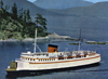
I have both the time and motivation to continue my way through this blog, albeit a bit sporadic.... ----------------- Days 7 & 8: Start: Canmore AB End: Waterton Lakes National Park, AB. All-Alberta days, and 2 good days they were.... I started my Saturday morning at sunrise, on the balcony of our motel in Canmore, taking morning photos of the 3-Sisters mountains, south-east of town. After that, we checked out, and this motel was probably the poorest of all the hotels for the complimentary breakfast. This was toast, frozen waffles and coffee from a machine (similar to a vending machine). I passed on all that.... We drove east on Hwy-1 for a short while, then turned south on Alberta Hwy-40, the Kananaskis Highway. This "only in summer" road was a high mountain highway, 2 lane paved. We passed the Whistler-like village of Kananaskis, and parts of the road were really high up. This is Calgary's playground, for sure. As the road ended and we turned south onto Hwy-22, we were in high-ranch country. - The "Cowboy Trail" Hwy-22 was a lovely road showing ranches and the rolling hills in the shadows of the Rockies. We reached the bottom of Hwy-22 and turned east on Crowsnest Highway 3, and then turned south to get to Pincher Creek, AB. My immigrant father almost ended up in Pincher Creek in 1949, but his relatives (his sponsor family) moved to Nanaimo soon before my father's immigration. We did the Co-op shop at Pincher Creek (gas & groceries), and headed down towards the south-west corner of Alberta to Waterton. We were in both Hutterite country and Mormon country, both groups highly visible in south-west Alberta. We arrived in Waterton in early Saturday afternoon, when the town was busy with day-tourists, many riding the 4-wheel "Surrey" bikes that the rental store had. The town was also busy for a wedding, including some street-photos that held up traffic for a bit; it was happy. Of course, I made my way to a lakeside park, to scout out the MV International ship, and enjoyed watching her sail on by. I bought our tickets for the next morning's sailing. Our hotel was an old 1930's country inn. Lots of the buildings in town are of that 1930s vintage, when the tourist town really got started with the Prince of Wales Hotel & ship. Our hotel was small (for the regular guest rooms, apparently), but we had a larger theme room, the "Bear Room" which had numerous bear figurines and stuffed-varieties, and bear artwork. There is a Subway restaurant in Waterton, only open for the summer months, and prices are a couple dollars higher for everything than your usual Subway. This is our type of eating place, so we went there for almost all our meals during our 2 day visit. Wildlife abounds in Waterton park, and the deer are plentiful in the townsite. We enjoyed moving through the town, looking for animals and doing in-town photography. My Sunday in Waterton started with a dawn photo shoot on the waterfront, for the Prince of Wales hotel and the MV International. We then did our morning cruise on the ship, from 9:30 to Noon. It was clear weather for the first half, but heavy rain for the 2nd half. We got wet from the various leaks that hit us as we sat in the open-sided Fantail-deck part of the boat's stern. - My entire MV International experience is fully documented in our forum's thread for that ship, here: ferriesbc.proboards.com/index.cgi?board=otherna&action=display&thread=8474After drying out from our boat cruise, we drove around the park a bit (Red Rocks Parkway) and visited the lobby of the Prince of Wales Hotel. I bought books on the MV International ship, the Prince of Wales Hotel, and the Going to the Sun road. And that was it for the very satisfying Saturday and Sunday in Alberta. Waterton is a place that is on our list to visit again in the future. - It was the surprise gem of the trip. We had wanted to visit there, but we didn't realize how beautiful and pleasant it was until we saw it for ourselves. |
|