SolDuc
Voyager  West Coast Cyclist
SolDuc and SOBC - Photo by Scott
West Coast Cyclist
SolDuc and SOBC - Photo by Scott
Posts: 2,055
|
Post by SolDuc on Jan 11, 2013 19:03:55 GMT -8
Hi all, My "ferrygeekness" probably comes from all of the maps I've studied and seen over and over, so I would like to start a maps thread here... I am a collectioner of NPS (US) maps and of the classical yearly Michelin France atlas (only even years). But the most amazing thing about that map passion is the maps that I'm making. They of course include a lot of ferry terminals (for a company named niceland ferries). For the quick story: I started this map back in october 2011, and I have worked on it 100+ hours. I did many enlargements over time, and replacement of some parts of the original paper that got yellowish. It is now over 2 times the original size. Technique: Patience. Draw, erase and redraw. Almost all is done in pencil When will I be done: Never (lol) Now pictures: Overall (you can see an other map rolled in the background)  A community named Market Island:  Holafix ferry terminal:  A town named "Ferry Borg"'s got a terminal with three destinations:  And two interchanges:   |
|
SolDuc
Voyager
West Coast Cyclist
SolDuc and SOBC - Photo by Scott
Posts: 2,055
|
Post by SolDuc on Jan 22, 2013 18:13:32 GMT -8
Yesterday I got done with a group of small islands (bridges, no ferries) and with market island. Pictures: That island group. Better not get lost if you're in a boat: 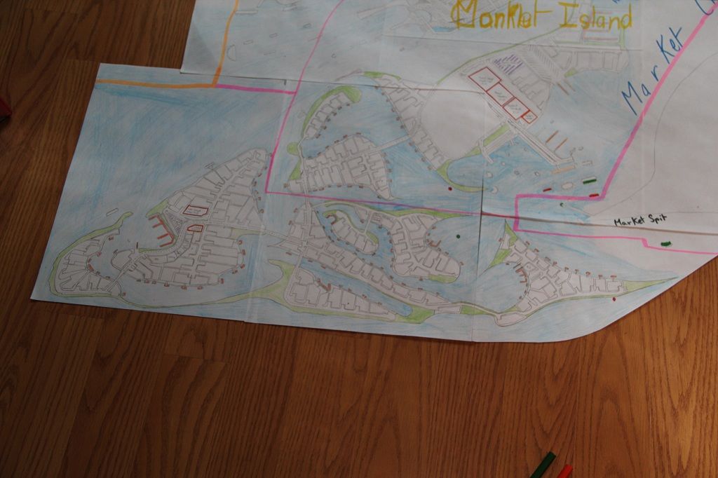 And Market Island, work in progress: 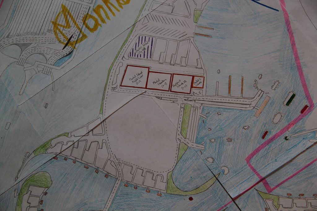 |
|
SolDuc
Voyager
West Coast Cyclist
SolDuc and SOBC - Photo by Scott
Posts: 2,055
|
Post by SolDuc on Jan 25, 2013 19:17:30 GMT -8
And another quick map update:
I found a way to move people around town while making no pollution at all! I call...the light rail on freeway!
The process is fairly simple, it is elongated buses on rails, and rails are on the HOV lanes of the interstates. I does requires a lot of freeway stations in the middle of the road with overpasses and all that stuff, but overall it is a relatively compact and eco-friendly system of transportation.
|
|
|
|
Post by compdude787 on Feb 6, 2013 23:02:21 GMT -8
Wow, are these like totally made-up places? Those are the kind of maps I draw too! The one difference is that the scale is different. Except for interchanges, I draw my maps at a more zoomed-out level, where each road is just a line. When I get the chance I should post some pics of the maps that I've drawn. I've drawn some of a whole big city, and another one of another city, as well as some showing some smaller towns. They're all connected to form a larger "map world." I've never met someone who has the same interest in drawing maps of made up places, so this is really cool!!!!  |
|
|
|
Post by compdude787 on Feb 6, 2013 23:08:29 GMT -8
Also my maps are never done either. I might take areas that I drew a long time ago and completely re-do them. THat's why I don't use pen nor marker on my maps, since you can't erase those. I don't really name my cities, but I do name the streets and number the freeways and highways.
|
|
|
|
Post by compdude787 on Feb 6, 2013 23:16:44 GMT -8
SolDuc, you should check out this site: www.openstreetmap.orgIt is a website where you can edit the map. Same concept as Wikipedia except with maps. It's pretty cool and addicting. You click the edit button when you see one thing wrong with the map, you fix that, then you see another thing wrong, you fix that, and then you see another thing wrong, you fix that, then you see another thing wrong...  |
|
SolDuc
Voyager
West Coast Cyclist
SolDuc and SOBC - Photo by Scott
Posts: 2,055
|
Post by SolDuc on Feb 7, 2013 17:33:08 GMT -8
SolDuc, you should check out this site: www.openstreetmap.orgIt is a website where you can edit the map. Same concept as Wikipedia except with maps. It's pretty cool and addicting. You click the edit button when you see one thing wrong with the map, you fix that, then you see another thing wrong, you fix that, and then you see another thing wrong, you fix that, then you see another thing wrong... I actually knew about this site and it has an GPSapp that goes with it. The only thing that I hate about the app is that it does NOT show bridges. That caused us to miss the ferry to Lopez back last spring... it was a big moment as you can imagine! |
|
|
|
Post by compdude787 on Feb 7, 2013 17:51:59 GMT -8
SolDuc, you should check out this site: www.openstreetmap.orgIt is a website where you can edit the map. Same concept as Wikipedia except with maps. It's pretty cool and addicting. You click the edit button when you see one thing wrong with the map, you fix that, then you see another thing wrong, you fix that, and then you see another thing wrong, you fix that, then you see another thing wrong... I actually knew about this site and it has an GPSapp that goes with it. The only thing that I hate about the app is that it does NOT show bridges. That caused us to miss the ferry to Lopez back last spring... it was a big moment as you can imagine! The app doesn't show bridges? What the heck?! BTW do you have an OSM account? If so, what's your username? |
|
SolDuc
Voyager
West Coast Cyclist
SolDuc and SOBC - Photo by Scott
Posts: 2,055
|
Post by SolDuc on Mar 2, 2013 22:17:53 GMT -8
Today I unrolled what is one of my oldest maps, which I started in France around 4.5 years back. The map is in a mix of French and English which only a few people would be able to understand. As I was not a big ferryfan back then there is only one ferry accessed island, but the number of ferry river crossings in increasing as the days go by. It is mainly inspired by Michelin maps though there is a few touches from Rand McNally and some of ny personal touches here and there. The map: 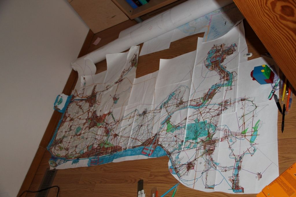 The very start - Bayardville - I have a more detailed map of this area (similar to the one mentioned earlier) that is just huge. It can barely fit in my room! 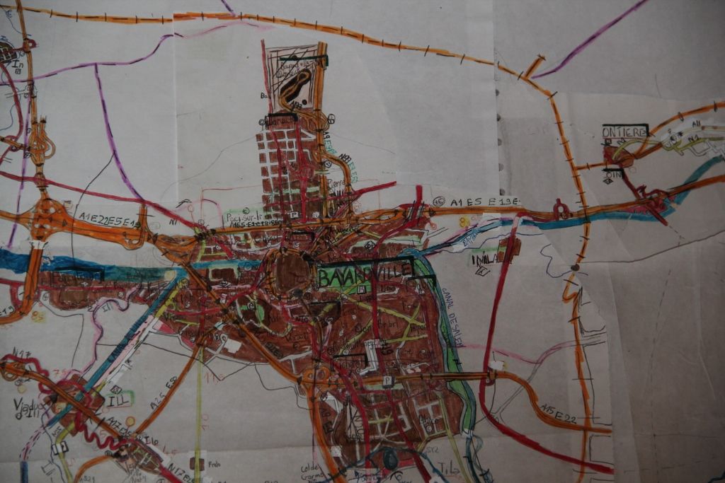 The general area that I'm working on. You can see two major seaports (pink), a huge National Park (green) and fairly large cities (brown). 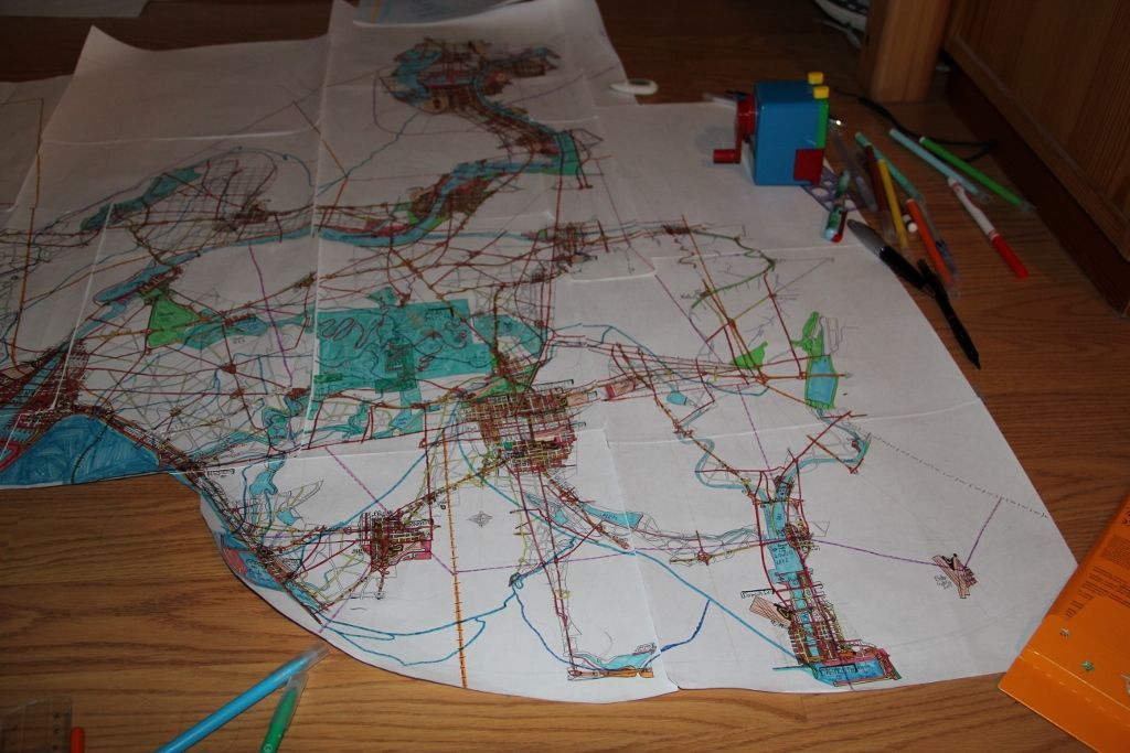 The area that I did today to finish with. The Futa River runs through very deep gorges surrounded by desert plateaus, similar to the Columbia River in Eastern Washington. To get into the valley you have to go through a very mountainous road that climbs/descends several hundred meters in just a few km. Similar to the US2's descend from/towards the Columbia (east of the river, not on the Wenatchee side) for those that have been there. Later the valley broadens, some cities appear and agriculture becomes the main land usage. 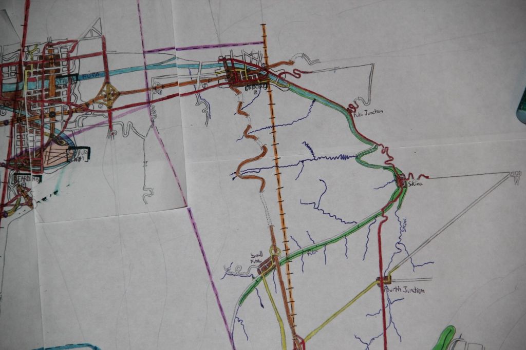 |
|
|
|
Post by Mike C on Mar 3, 2013 0:24:05 GMT -8
Your maps are awesome, SolDuc! I'm extremely impressed with the level of detail involved in your drawings. You should be proud. I do quite a bit of community mapping for school. When I was a kid, I would draw my maps by hand. Today, I create maps using Adobe Illustrator, ArcGIS, and AutoCAD, for various school projects. I'm not sure if this is actually cartography, but here are some examples: Made in Adobe Illustrator (direct links due to zoom and text viewing) i169.photobucket.com/albums/u237/mainlander101/ThirdPlacesMapII.pngi169.photobucket.com/albums/u237/mainlander101/CorridorStrategyMap.pngMade in AutoCAD (these seemed to have been somewhat butchered in the process of converting to image files from .dwg, sorry about that)   |
|
SolDuc
Voyager
West Coast Cyclist
SolDuc and SOBC - Photo by Scott
Posts: 2,055
|
Post by SolDuc on Jan 13, 2014 21:04:51 GMT -8
So over the last few months I've done more and more urban/transit planning cartography. I thought it might be time to share some of my work with the forum. Back in September/October I did yet another version of my Seattle HCT map (this was version 3.1, and I currently have a list of new lines and stations that I need to include in the yet to-be-drawn version 4.0. I've always liked envisioned new highways and since I realized that just keeping on building and expanding highways, especially in cities, wasn't sustainable I turned towards transit and began to draw maps of what needed to happen for Transit in Seattle. In June I drew my first map with the four main LINK trunk lines and a handful of streetcar lines, then later in the summer I drew version 2.0 where I added four streetcar lines and all the ferries. Version 3.0 was drawn for my geography teacher and includes slightly different stations than in version 3.1. If you want to know more about the logistics of my system, just click on the map and read the description on the Flickr Page. 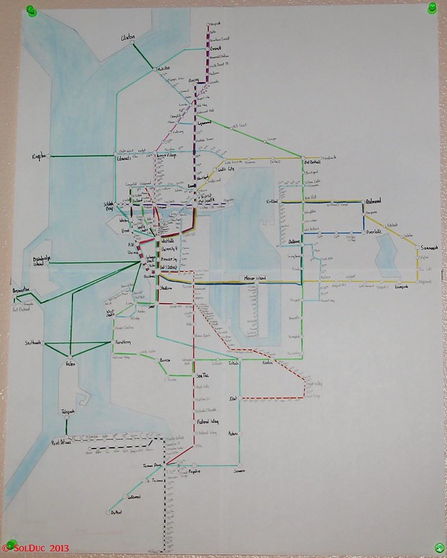 Envisioned Seattle Area HCT Envisioned Seattle Area HCT by SolDuc Photography, on Flickr Version 4.0 will include two more LINK lines as well as expansions of the lines I have and even more streetcar lines. Last weekend I focused on Urban Planning and basically re-did the whole Tukwila-International Boulevard Station (TIBS) area, changing the land use from Strip Malls and Parking Lots to condos, residential towers, lid-parks and office space, creating 7,164 units of housing which would lead the Tukwila Population to double. Again, click on the image for more in depth explanations. 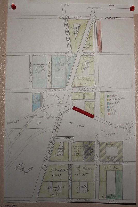 The New TIBS! The New TIBS! by SolDuc Photography, on Flickr |
|
|
|
Post by Mike C on Jan 14, 2014 11:14:57 GMT -8
Last weekend I focused on Urban Planning and basically re-did the whole Tukwila-International Boulevard Station (TIBS) area, changing the land use from Strip Malls and Parking Lots to condos, residential towers, lid-parks and office space, creating 7,164 units of housing which would lead the Tukwila Population to double. Again, click on the image for more in depth explanations. Your version of a TOC (Transit Oriented Community) caught my eye for Tukwila/International Blvd. If you (or anyone else here is interested), TransLink has some fantastic resources for land-use planning around rapid transportation connections. They use Vancouver in most examples, but the principles can be applied pretty much universally. Transit-Oriented Communities Strategy: www.translink.ca/en/Plans-and-Projects/Transit-Oriented-Communities.aspxManaging the Transit Network: www.translink.ca/en/Plans-and-Projects/Managing-the-Transit-Network/Network-Design-Objectives.aspx |
|