|
|
Post by Scott on Apr 7, 2007 22:35:13 GMT -8
I know this topic is about as old as the forum itself, but there always seems to be lots of ideas to throw out there. On another thread the following posts were made and I've created this thread to encourage it to continue. It might be unrealistic, but it's fun. So here's a place to discuss your ideas, as unworldly as they might be:) Does anyone know if BC Ferries has a plan for the Bowen Queen over the May long weekend. If they don't they maybe they should try using the Bowen Queen from Tsawwassen to Galiano, Mayne, Pender, and then to Sidney. It probably would work. WSF is only in the dock from 10:45-11:40 so if they leave Tsawwassen at 11 arrive Galiano at 11:55 leave at 12:05, arrive at Mayne at 12:35. Leave at 12:45, arrive Pender at 1:05 leave at 1:15 and Arrive Sidney 2:15. Then on the way back do the same thing only leave at 3 from Sidney, 4:15 from Pender, 4:45 from Mayne, and leave Galiano at 5:25 and arrive at Tsawwassen at 6:20 so what do you think??? I think that Harry lives. I believe that the point of your post is to brainstorm a possible BC-Ferry use for the Sidney Terminal....but Swartz is just up the road from Sidney, and that's the main problem with your suggestion. With Swartz so close by, there's no need for Sidney for such a run. But it is neat to get the map and look at the clock, and think of the possibilities. I remember Harry once proposing a route from Galiano to Gabriola. It sounded like a fun thing to think about, but it was clearly only a fantasy with no chance of reality. I asked him about Porlier Pass, Dodds Narrows, and 1st Nations land on Galiano, and I never heard back. But that was then. re your Sidney route: I presume that you're not seriously thinking that BC ferries could or would do such a route for next month? I presume that you're just brainstorming some possibilities. Here's one: Use Sidney terminal to run the Saanich and Vancouver from Sidney, through Boundary Passage, and up to Tsawwassen. Call it route 1A. On Sunday's, have the vessel call-in on the south-east side of Saturna (build a new terminal for that). I'm not making fun....I'm just playing the dream game too. Maps show endless possibilities for travel routes....but not all are practical or possible. But it can be fun to shut off the reality and dream about all those possibilities........... Some dream ferry routes I have thought of, Swartz Bay to HSB, TSA to Comox, Port Hardy to Skidegate. I wonder how well at PH to Skidegate direct route would do? Then you wouldent have to go through Prince Rupert. lol! We can dream. lol! Not that practical though I wouldent think! One dream route I've thought of is Lund(Powell River)-Savary-Cortes with a 40 car Kwuna-like vessel. I've also thought about Horseshoe Bay-Swartz Bay and Gabriola-Galiano. |
|
|
|
Post by Scott on Apr 7, 2007 22:37:46 GMT -8
Karl already mentioned one idea I've thought about - that is Horseshoe Bay or Tsawwassen to Comox. Comox/Courtenay are booming towns and I don't think Departure Bay can handle much more traffic, even if the terminal is improved. Maybe they could even do a morning and evening stop-over at Lasqueti Island on the way:)
|
|
|
|
Post by Political Incorrectness on Apr 7, 2007 23:34:55 GMT -8
What I think should happen is Duke Point get two more berths and expand the holding lanes to the max and add more terminal services. Move the whole operation out to Duke Point and sell the Departure Bay land instead of investing to an area that will not handle capacity in 10 years.
|
|
|
|
Post by hergfest on Apr 8, 2007 3:43:30 GMT -8
I don't see anyone using a Comox to the South run. The Island Highway is a great road north of Nanaimo, it gets you there much faster.
|
|
Koastal Karl
Voyager  Been on every BC Ferry now!!!!!
Posts: 7,747
|
Post by Koastal Karl on Apr 8, 2007 8:07:52 GMT -8
How about a HSB to Squamish??? Avoid the Sea to Sky highway. Might be a neat cruise.
|
|
|
|
Post by Political Incorrectness on Apr 8, 2007 9:05:10 GMT -8
When you can take the highway for free, be nice when there is a collision.
|
|
|
|
Post by NMcKay on Apr 8, 2007 9:15:02 GMT -8
The duke point think won't work. they have DPB just for the reason that it is closer to the main sections of town.
(Moderator edit to add one little ' mark)
|
|
|
|
Post by Ferryman on Apr 8, 2007 9:52:22 GMT -8
How about a HSB to Squamish??? Avoid the Sea to Sky highway. Might be a neat cruise. I've always thought that would be a neat cruise as well. Though I don't think it would be worth putting a car ferry on the run, and competing with the highway time. They could at least have a passenger Ferry that could fit BCF docks, and run it back and forth. Howe Sound has some great scenery. Alot of people don't really understand that, and they just assume they have to go up North to get good scenery. You get a completely different perspective of Howe Sound, once you've explored it by boat, which is what I've learned from personal experience. A few years ago, when the Royal Hudson was running, you used to be able to ride the train to Squamish from Vancouver. Then on the return trip, you had the option of going back to Vancouver on the MV Britannia, or vice versa. I got to sail on the MV Britannia on the evening of my Grad, and we sailed all over Howe Sound for the majority of the night. Very nice little ship, with two passenger decks (both with a bar), with access to a third outer deck. Does anyone remember when BC Ferries was doing studies in the early 90s, for where they should build another terminal? Of course we know they picked Duke Point, but does anyone remember any other places they had considered? I remember them looking at Ladysmith for building another terminal. Then ferries would have to travel across Stuart Channel, and down Trincomali Channel to Porlier Pass, then over to Tsawwassen. |
|
|
|
Post by Mike C on Apr 8, 2007 10:18:51 GMT -8
I remember reading in 'Island Tides' that they were considering making a YVR-East Gabriola route. Of course it never happened. The citizens of Gabriola were outraged.
But it would be funny if it did...
|
|
|
|
Post by markkarj on Apr 8, 2007 11:45:41 GMT -8
What I think should happen is Duke Point get two more berths and expand the holding lanes to the max and add more terminal services. Move the whole operation out to Duke Point and sell the Departure Bay land instead of investing to an area that will not handle capacity in 10 years. How much time/distance would be added to a sailing by sending ships from HSB to Duke Point rather than Departure Bay? I remember a fellow from BC Ferries telling me that the fast cats were supposed to solve the problem of congestion at Departure Bay and HSB by allegedly sailing faster and dropping vehicles down in smaller, more managed "pulses" than the big ships that drop a huge number of cars off all at once. I guess that didn't work out. But given that logic, it's got me thinking: instead of the Super-C class ships on HSB to Departure Bay, would it make more sense to have a few more of the stretched Burnaby class ships that would sail with greater frequency, dropping off 200 cars every hour rather than 400 cars every two hours? I realize the costs would be higher in terms of shipboard labour and outlay for new vessels, but it could manage the traffic problem. |
|
|
|
Post by Political Incorrectness on Apr 8, 2007 12:55:14 GMT -8
I don't think there would be much of a time difference though I could be completely wrong on that. It would take away traffic off 19A and shift it onto the parkway, but the parkway probably should get some overpasses or underpasses at intersections that can accomadate them before a move happens. What I do not see behind the logic is that you carry the same capacity in the same amount of time which is why they pack up the vessels, now pax wise would be a different story. Since the Super Cs still can only carry 1650 passengers (though they are bigger than the C class), yet carry almost 400 yet the Vs can carry 200 cars and 1100 pax, would make a difference but is there enough foot traffic to justify the four vessels or do they need another boat?
|
|
|
|
Post by nolonger on Apr 8, 2007 16:40:17 GMT -8
We used to sail out of DepBay on rte 30 and the time difference was pretty much zero. The same would be true for HSB to Duke. We have sailed from Duke to Horseshoe Bay due to heavy weather and Tswwassen being closed. Except for the infamous 8 hour crossing the time difference is negligible.
Traffic congestion can always be relieved by adding more sailings but then fuel and other operating costs go up. The most efficient way of course is to run full boats, but we do need a regular schedule. Back in the early '70s we ran 2 boats on rtes 1 and 2 with 2 others on standby, meaning they were manned and ready to go if needed, but not very cost effective.
|
|
|
|
Post by Curtis on Apr 8, 2007 16:44:54 GMT -8
Just thinking of some possible routes. Would be an intresting idea having a Sechelt-Texada route, or better yet, Departure Bay-Langdale. Maybe there will be a Powell River-Texada-Comox Route someday. What about a Victoria-Prince Rupert cruise?
Plenty of possibilities out there.
|
|
D'Elete BC in NJ
Voyager
Dispensing gallons of useless information daily...
Posts: 1,671
|
Post by D'Elete BC in NJ on Apr 9, 2007 5:17:38 GMT -8
Or better yet, a Horseshoe Bay to southern Texada route...though the Islanders might string me up for suggesting it! ;D
|
|
|
|
Post by Gunny on Apr 9, 2007 8:37:46 GMT -8
Departure Bay-Langdale. Maybe there will be a Powell River-Texada-Comox Route someday. So like the triangle route that they discontinued a while ago (there was a few sailings that did DPB, to Langdale via HSB, one which you could buy a direct ticket), I also think someone mentioned that the Comox-PR boat did stop in on Texada on the early sailing or the late sailing, but I cannot recall who nor have any substantiative evidence. My dream route would be something on the West Coast... maybe Ukee to Bamfield via the Broken Group. If the Garabaldi II could handle the weather be a good route for her. Really, other than Lasqueti, who don't want car service, there aren't any islands that jump out as developed enough for vehicle service... If you can buy an Island, make a deal with the Corp... er Service for a ferry and Subdivide and sell it in Alberta, maybe able to make some money. |
|
D'Elete BC in NJ
Voyager
Dispensing gallons of useless information daily...
Posts: 1,671
|
Post by D'Elete BC in NJ on Apr 9, 2007 9:27:23 GMT -8
Departure Bay-Langdale. Maybe there will be a Powell River-Texada-Comox Route someday. ...I also think someone mentioned that the Comox-PR boat did stop in on Texada on the early sailing or the late sailing, but I cannot recall who nor have any substantiative evidence... lol...I did, and so did PR Northern Teen, and maybe Flugel Horn. As I commented before, the route was great for people on Texada as it eliminated a convoluted scheduling dance when travelling to the Island. |
|
|
|
Post by Balfour on Apr 11, 2007 17:40:18 GMT -8
I once suggested that routes 2 and 3 be interlined, ie. have the Queen of Oak Bay do one trip from Dep Bay to Horseshoe, then a round trip on route 3 then back to Dep Bay.
This idea could offer passengers an option to pay 1 fare to get from the Island to the Sunshine coast or vice versa.
|
|
|
|
Post by BrianWilliams on Apr 11, 2007 20:49:55 GMT -8
I am surprised that Vancouver-Squamish ferry services haven't been talked about much lately in the press.
The billion-dollar improvements to Hwy 99 are needed - not just for 10 days of Olympic frenzy, but to support 99 as a very good highway to interior BC.
We can't beat geology, weather and topography by brute force, though. We could take a lesson from Norway, a country that has made a highway to their North Cape with superb roads and ferry links.
99 will never be an all-weather, all-season 6-lane highway without blasting away ten billion tons of Coast Mountain granite from Lions Bay to Britannia. Let's accept that, and make provision for a speedy car ferry as a supplement.
BCF? Maybe not. Perhaps entrepreneurs can bid on a route from Horseshoe Bay to Squamish. Their subsidies would include access to the HB terminal, and even a share of the highway maintenance budget for Hwy 99.
Last note: road bypasses of the Howe Sound route are old and well known. North Vancouver's Lillooet Road is just that: an 1860's wagon/cattle road that ascended the Seymour River to the pass that opened into the Stawamus Valley, then down to Squamish. The route on to Lillooet and the Cariboo was more problematic - and the road died.
Today, re-opening the Seymour Valley road as a public highway is unthinkable. There is a fine gravel road all the way to Squamish from the top of Lillooet Road. But the Seymour River and the upper Stawamus are protected as suppliers of the finest, safest drinking water to 3 million people. As a by-product, the vast valleys are human-free wilderness. 10 miles from Canada's 3rd largest city. No public highway, please.
|
|
|
|
Post by WettCoast on Apr 11, 2007 21:51:08 GMT -8
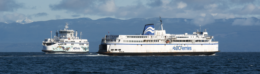
This is not my dream, but more of a "Why did they not do this, anyways?" 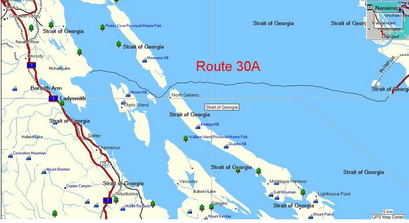 Route 30 could have been much shorter by going through Porlier Pass, just north of Galiano, then making there way to a new terminal constructed north-east of Ladysmith. With such a route a four hour turn around as on routes 1 & 2 should be possible. I have no idea about suitable points to build a terminal or available land for a terminal and new highways, but I do believe such a route to be feasible and attractive. What I don't know about is navigational issues on such a route. BTW, the line for the route is drawn free-hand with mouse and wanders too close to Reid Island, west of Porlier Pass. The route would, of course, be out in mid channel. My dream would be a route from Kitimat directly south to the north end of Vancouver Island. |
|
|
|
Post by Ferryman on Apr 11, 2007 22:18:26 GMT -8
Route 30 could have been much shorter by going through Porlier Pass, just north of Galiano, then making there way to a new terminal constructed north-east of Ladysmith. With such a route a four hour turn around as on routes 1 & 2 should be possible. I have no idea about suitable points to build a terminal or available land for a terminal and new highways, but I do believe such a route to be feasible and attractive. What I don't know about is navigational issues on such a route. I like the idea too, Jim. Minor problem....The terminal you have drawn a Ferry route to land right on top of the Yellow Point Lodge. But I understand what you mean though. The only problem is access to Yellow Point, which is probably why BCF turned this option down 15 or so years ago. Yellow Point Road is a fairly windy road, with rolling hills, and I couldn't imagine trains of semi trucks trying to do this road. So a new highway would obviously be needed, much like with the Duke Point situation. This area is considered to be part of the Booney area of Ladysmith/Nanaimo, and the people that live out there have decided to live there for the same reason that everyone else has for living in the boonies. Which is to get away from the City Life. I can't blame them, it's beautiful out there. The residents out there would never allow it. |
|
|
|
Post by WettCoast on Apr 11, 2007 22:45:15 GMT -8
What about in or close to Ladysmith Harbour?
|
|
|
|
Post by Ferryman on Apr 12, 2007 7:37:43 GMT -8
I couldn't ever imagine a Ferries trying to come into Ladysmith Harbour. In the summer, it's covered with various types of pleasure crafts either coming or going to the Gulf Islands. Any further south of Yellow Point, you get into Kulleet Bay, which is Native land. This land spans from about Kulleet Bay to Coffin Point. Basically everything on the East side of Ladysmith Harbour. Plus along the waterfront everywhere else in places such as Saltaire, it is dotted with homes and subdivisions. So if BC Ferries was serious and determined to put a Ferry Terminal near Ladysmith, they would have to build another Tsawwassen (man made Island and causeway).
|
|
Kam
Voyager
Posts: 926
|
Post by Kam on Apr 12, 2007 8:11:21 GMT -8
How about a HSB to Squamish??? Avoid the Sea to Sky highway. Might be a neat cruise. Does anyone remember when BC Ferries was doing studies in the early 90s, for where they should build another terminal? Of course we know they picked Duke Point, but does anyone remember any other places they had considered? I remember them looking at Ladysmith for building another terminal. Then ferries would have to travel across Stuart Channel, and down Trincomali Channel to Porlier Pass, then over to Tsawwassen. I sure do! I was working as a TV camera man at the time and remember covering all the events around the new terminals. Nanoose Bay was a serious consideration for the new terminal, as was Gabriola Island. |
|
|
|
Post by kylefossett on Apr 12, 2007 11:22:59 GMT -8
have you ever been through porlier pass? there has been a ferry to go through but was not recommended. the day of the alberni grounding in active pass the queen of sidney, after waiting off active pass for a couple of hours, went up tincomali channel to porlier pass and then on to tsawwassen. how do i know this? well the master on the sidney that day was an uncle of mine. some of our older ferries employees on here may know who he is.
ladysmith harbour could handle ferries. it is a able to handle deep sea freighters.
|
|
|
|
Post by Political Incorrectness on Apr 12, 2007 12:41:41 GMT -8
Well do most trucks that currently utilize route 30 go north or south on the island highway? Even though the section of the Island Highway in Ladysmith has many lights, could traffic still be utilized there effectively without creating more traffic?
|
|