|
|
Post by Northern Exploration on May 20, 2008 16:43:14 GMT -8
If I translate BCinNJ and DNelson for us regular folks  it means the route would be quite dangerous. To make safe for navigation at the lowest of tides there would be a massive amount of blasting needed with an extreme monetary and environmental cost. Correct me if my translation is incorrect.  |
|
|
|
Post by ruddernut on May 20, 2008 16:45:13 GMT -8
So Porlier is like an underwater equivalent of a mountain pass, whereas Active is an underwater equivalent of a valley?
|
|
|
|
Post by DENelson83 on May 20, 2008 16:53:10 GMT -8
I guess you could put it that way.
|
|
|
|
Post by johnnytindale on May 20, 2008 17:13:56 GMT -8
On the topic of Porlier Pass, I'm wondering if the freighters and and barges going to and from the mills in Crofton and Chemainus transit through this pass (they must given the limited options). If so, then given the extent of this traffic volume, it must be fairly safe, no??
While this discussion is rather interesting, given the millions invested in the Duke Point terminal, there is no chance of a terminal being built at Yellow Point.
|
|
D'Elete BC in NJ
Voyager  Dispensing gallons of useless information daily...
Posts: 1,671
|
Post by D'Elete BC in NJ on May 20, 2008 17:15:24 GMT -8
If I remember right they are still considered hazards, and the measurement is from higher high water. So knock 3 or 4 metres off those measurements to get minimum clearances...I see three navigational hazards that would concern me...especially if a ship is moving at speed. This has to do with the squat effect of a ship as it moves through the water at speed, and another suction-like effect caused by a ship moving over a shallow sea floor at speed. Now...why don't we look at those two charts, and do some comparisons. Look how much narrower Porlier Pass is at its narrowest, and the number of hazards near the center of the channel...now try navigating this in a 10 knot current...which is not uncommon for Porlier Pass...Active Pass maxes out around 5 and 1/2 knots. In either case, you are going to have to slow down, which was my point before. Cs and Coastals would have to operate in mode 2...no other choice. As for blasting your way through...yes, the explosives have gotten more "efficient"...you need less modern explosive than in 58, but you still need to release the same amount of energy to get the same effect, and it has to dissipate somewhere. Try explaining the fish and animal kill to the Sierra Club. |
|
D'Elete BC in NJ
Voyager
Dispensing gallons of useless information daily...
Posts: 1,671
|
Post by D'Elete BC in NJ on May 20, 2008 17:25:16 GMT -8
If I translate BCinNJ and DNelson for us regular folks it means the route would be quite dangerous. To make safe for navigation at the lowest of tides there would be a massive amount of blasting needed with an extreme monetary and environmental cost. Correct me if my translation is incorrect. wha, i don speek englash no...i'ma gonna hava put you in dem ceement shoes wee been discassin... |
|
|
|
Post by kylefossett on May 20, 2008 17:41:42 GMT -8
Freighters bound for Chemainus and Crofton use Boundary Pass and the Trincomli Channel.
|
|
|
|
Post by ruddernut on May 20, 2008 17:46:41 GMT -8
I wonder if an underwater canal can be carved out in a straight line path with minimal blasting and destruction, with a series of closely placed buoys to guide the ships through safe passage.
|
|
|
|
Post by Northern Exploration on May 20, 2008 18:43:36 GMT -8
The boy's been in Jersey too long you need a BC visit fast. I am allergic to the lime in cement so will pass thanks ;D. |
|
|
|
Post by DENelson83 on May 20, 2008 20:16:54 GMT -8
If I remember right they are still considered hazards, and the measurement is from higher high water. So knock 3 or 4 metres off those measurements to get minimum clearances...I see three navigational hazards that would concern me...especially if a ship is moving at speed. This has to do with the squat effect of a ship as it moves through the water at speed, and another suction-like effect caused by a ship moving over a shallow sea floor at speed. Looking at the fundamental notes for the Porlier Pass chart (CHS chart 3473): "DEPTHS are in metres and are reduced to Chart Datum (Lowest Normal Tide), which at Montague Harbour is 2.5 metres below Mean Water Level." "ELEVATIONS, spot elevations and clearances are in metres above Higher High Water, Large Tide. Underlined figures on drying areas or in brackets against drying features are in metres above Chart Datum. Topographic contours are above Mean Sea Level at an interval of 20 metres." |
|
|
|
Post by WettCoast on May 20, 2008 21:02:46 GMT -8
In comparing Porlier & Active Passes I believe the differences in overall navigational issues are not huge. If Active Pass was 'scored' at a 3 out of 5 then maybe Porlier would score a 2 out of 5. I am by no means an expert in navigational issues relating to these places. I gather that we don't have such a person on this forum. Nevertheless, I offer some things to consider:
- Porlier would not be mid route for ferries en route between Tsawwassen and a terminal near Yellow Point on the Island. As such ferries that leave opposite terminals at the same time would be passing outside (east) of Porlier. By contrast Active Pass is right in the middle, and the ferries pass there. Often in Active Pass there are simultaneously three larger vessels and sometimes a smaller fourth one. When I was a kid I thought that Active Pass was named for the fact that ferries were always in the 'act of passing' there.
- Porlier does not have the curvature that Active does.
- Overall, Porlier is wider. However, its useful width may be less.
- In most (all) other respects it appears that Active Pass is superior.
- It may be possible to make Porlier much more ferry friendly with a limited amount of judicious blasting and installation of various navigational aids.
- Active Pass's use by regularly scheduled passenger ships traveling between Vancouver and Victoria predates BC Ferries. In fact it predates CP's BC Coast Service.
As for a terminal on the Island side - Yellow Point is likely a no go for a variety of reasons. However, something a little further south toward Ladysmith might be possible.
When route 30 was being planned twenty years ago I would assume that a route through Porlier Pass was given consideration. Does anyone know? The decision to go all the way from Tsawwassen to Departure Bay (later Duke Point) seems odd as it has meant having a route considerably longer than other mainline crossings. This has resulted in a host of extra costs such as a twenty hour operational day, the need for faster ships with more horsepower and greater fuel burn, etc.
Consider also that back in the 1970's and early 80's the BC government was considering a short route with about a 50 minute crossing time. This would have gone from Iona Island near Vancouver airport to Sear Island at the south east end of Gabriola. Gabriola would have been connected to Vancouver Island by bridges and Mudge Island. This plan did not have a large amount of support (surprise!) from the 'locals' (NIMBY's) on either side.
|
|
|
|
Post by Ferryman on May 20, 2008 22:44:02 GMT -8
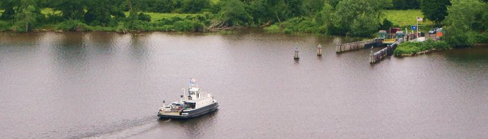
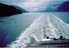
I spent the weekend at friends house, who ironically lives on Yellow Point. The marked spot on the google map you have posted, ruddernut, is on top of the Yellow Point Lodge. Now I've never stayed there, yet I've been around the area many times after living in Ladysmith/Saltair for 14 years (1989-2003). There is, as others have mentioned, lots of farm land and acreage that a good handfull of people own. It's considered the boonies, or the sticks area of Ladysmith and Nanaimo. Chances are, any potential areas for a Ferry terminal would be owned by someone who has a well developed farm, that has been in the family for years. But say, just by chance, BC Ferries found a parcel of land, large enough for a terminal. The next issue is getting there. Sure you could widen Yellow Point road, and Cedar Road, but there would be heck to pay with all of the surrounding residents. They would in fact have a say in the matter, because chances are the extra land needed to widen the road would cut into their property. The current road has a speed limit of 60 km/h, and is full of twists, and long hills. It only takes about 10 minutes to reach 10-15 mins, to drive to Yellow Point from the Highway. Or, We cut across everyones land, with a brand new 4 lane highway. Now I'm unsure of what sort of loops the NDP and BC Ferries had to jump through back in the 90's as they were building Duke Point, but that's a similar situation to this. The only difference though, is that Duke Point was already an industrial area, with growing traffic of its own. So the Harmac pulp mill, and the Sawmill out there would have encouraged the project to go ahead. Yellow Point however wouldn't have any support like that. But believe me, BC Ferries has already looked at Yellow Point as a potential terminal location, having Ferry routing through Porlier Pass. But this was of course well before Duke Point was ever built. Also, moving South from Yellow Point towards Kulleet bay, you run into a huge First Nations land reserve. This land reserve spans from Kulleet Bay to Coffin Point, which is basically the entire peninsula on the opposite side of Ladysmith Harbour. Now, for running a Ferry through Porlier Pass. I've spent 5 summers fishing for Spring Salmon in our boat near the mouth of this Pass, on both the Strait side and Trincomali Channel. I've driven our little 16 foot Double Eagle through here in almost every condition. There have times where we've had to turn around mid way through the Pass, because the wind combined with the Rapids and whirlpools would become too intense. Active Pass is Narrow too, but Porlier Pass has more obstructions. There's a light in the middle of the Pass, sitting at the highest point on the rocks, but the rocks are covered by water during high tide. It's not recommened to travell on the Valdez Island side of the light, as you can never be too sure where the rocks are. During the low tide, most of the rocks are evident. If you have a chart of this Pass, you'll notice the rocky areas. I've never seen any huge ships sail through here before, but have seen plenty of tug and barge transit the pass. Usually they try to take advantage of the Flood and Ebb tides, which is the turning point for the tides, and the currents almost stops for a brief time. The currents really push our little boat around, so I'd usually have to really be leaning on the throttle on the 90 hp engine. It's pretty fun to ride through the pass in the currents. Here's some pics from my last venture out to Porlier Pass in the summer of 2006. This first pic is us looking straight at the Pass from the Strait of Georgia side. Galiano is on the left, while Valdez is on the right. This was during High tide, but the currents were only just starting to become active again as the Flood tide was nearly over. 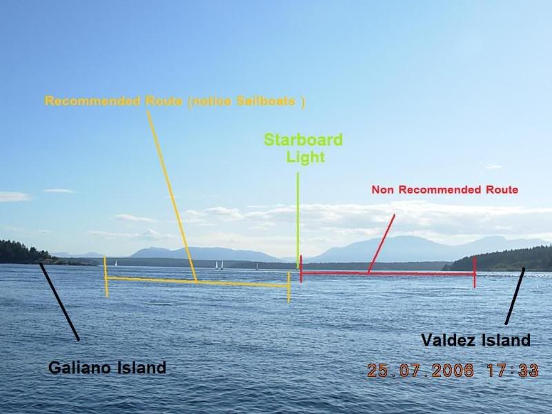 Here's some rapids we experienced, which were relatively calm compared to other times we've gone through. 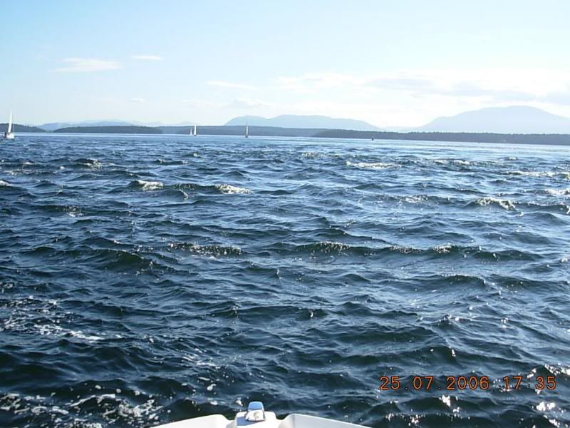 Finally, looking at the Pass, once we entered Trincomali Channel. 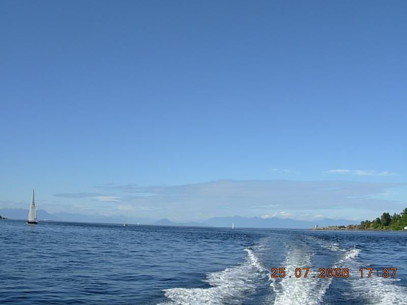 Hopefully this has answered some questions. |
|
|
|
Post by ruddernut on May 21, 2008 6:21:48 GMT -8
There is, as others have mentioned, lots of farm land and acreage that a good handfull of people own. It's considered the boonies, or the sticks area of Ladysmith and Nanaimo. Chances are, any potential areas for a Ferry terminal would be owned by someone who has a well developed farm, that has been in the family for years. Here is a Google satellite view of the area: maps.google.com/maps?f=q&hl=en&geocode=&q=ladysmith&sll=49.26045,-123.11394&sspn=0.238399,0.452499&ie=UTF8&ll=49.035195,-123.757596&spn=0.014968,0.028281&t=h&z=15 The foot of Hills Road looks like it's all wooded area. The foot of Seidel Road looks like a more ideal location for a terminal, but seems to have a farm nearby. What about the bay to the southwest of the point? How much of that is Native owned? But say, just by chance, BC Ferries found a parcel of land, large enough for a terminal. The next issue is getting there. Sure you could widen Yellow Point road, and Cedar Road, but there would be heck to pay with all of the surrounding residents. They would in fact have a say in the matter, because chances are the extra land needed to widen the road would cut into their property. About as doable as widening Pacific Highway from Hwy 1 to the border crossing, I'm sure. Safe for small sailboats doesn't mean it's safe for a big ferry, does it? |
|
Neil
Voyager
Posts: 7,268
|
Post by Neil on May 21, 2008 11:31:57 GMT -8
350 acres of the Duke Point area were already owned by the province, which no doubt made land and access routes somewhat easier to assemble, and, being industrial, it was much less disruptive than building at Yellow Point, which as Chris has pointed out, is well established as rural/residential/agricultural. As well, access to the new highway was shorter and more straightforward at Duke. The fact that Duke Point came in on time and $6 million under budget would indicate that the choice was a good one, with few unforseen complications.
Along with possible navigation hazards through Porlier Pass, we know nothing of the shoreline specifics of terminal construction at Yellow Point, environmental concerns, local community disruption, expropriation costs, traffic compound capacity, or access options. So while taking a map and a magic marker and drawing a line between two points might make for some ferry fan fun, chances are there were very good reasons for building where they did.
|
|
|
|
Post by ruddernut on May 21, 2008 12:03:49 GMT -8
Consider also that back in the 1970's and early 80's the BC government was considering a short route with about a 50 minute crossing time. This would have gone from Iona Island near Vancouver airport to Sear Island at the south east end of Gabriola. Gabriola would have been connected to Vancouver Island by bridges and Mudge Island. This plan did not have a large amount of support (surprise!) from the 'locals' (NIMBY's) on either side. Would there be much of a NIMBY problem on the east side, considering all that there are on Iona Island and adjacent properties are a sewage treatment facility and an airport, with no residentials? Or were some wetlands conservationists and the Wreck Beach Preservation Society in on it too? |
|
D'Elete BC in NJ
Voyager
Dispensing gallons of useless information daily...
Posts: 1,671
|
Post by D'Elete BC in NJ on May 21, 2008 18:08:40 GMT -8
Consider also that back in the 1970's and early 80's the BC government was considering a short route with about a 50 minute crossing time. This would have gone from Iona Island near Vancouver airport to Sear Island at the south east end of Gabriola. Gabriola would have been connected to Vancouver Island by bridges and Mudge Island. This plan did not have a large amount of support (surprise!) from the 'locals' (NIMBY's) on either side. Would there be much of a NIMBY problem on the east side, considering all that there are on Iona Island and adjacent properties are a sewage treatment facility and an airport, with no residentials? Or were some wetlands conservationists and the Wreck Beach Preservation Society in on it too? You know, I have a bunch of poison ivy in my backyard I have a real NIMBY attitude about...I ripped it all out, and got a rash in return. Then it came back, so I dumped Roundup on it and that worked for awhile, but it's back now. I have heard continually running it over with the lawn mower might work... Seriously though...those environmental groups, while sometimes a little irritating to those who they choose to protest against, do make us a little more conscious of our impact on the world. |
|
|
|
Post by Political Incorrectness on May 21, 2008 18:49:56 GMT -8
Consider also that back in the 1970's and early 80's the BC government was considering a short route with about a 50 minute crossing time. This would have gone from Iona Island near Vancouver airport to Sear Island at the south east end of Gabriola. Gabriola would have been connected to Vancouver Island by bridges and Mudge Island. This plan did not have a large amount of support (surprise!) from the 'locals' (NIMBY's) on either side. Would there be much of a NIMBY problem on the east side, considering all that there are on Iona Island and adjacent properties are a sewage treatment facility and an airport, with no residentials? Or were some wetlands conservationists and the Wreck Beach Preservation Society in on it too? Does everyone get there way in a democracy? |
|
|
|
Post by ruddernut on May 21, 2008 18:59:19 GMT -8
Would there be much of a NIMBY problem on the east side, considering all that there are on Iona Island and adjacent properties are a sewage treatment facility and an airport, with no residentials? Or were some wetlands conservationists and the Wreck Beach Preservation Society in on it too? You know, I have a bunch of poison ivy in my backyard I have a real NIMBY attitude about...I ripped it all out, and got a rash in return. Then it came back, so I dumped Roundup on it and that worked for awhile, but it's back now. I have heard continually running it over with the lawn mower might work... Seriously though...those environmental groups, while sometimes a little irritating to those who they choose to protest against, do make us a little more conscious of our impact on the world. Agreed. I'd hardly call them NIMBY's either. Just wondering who the people are that would oppose development in that area. Does everyone get there way in a democracy? It's two wolves and a sheep deciding on dinner.  |
|
|
|
Post by DENelson83 on May 21, 2008 20:57:28 GMT -8
Does everyone get there way in a democracy? In Switzerland, there's something called "direct democracy," which I think is the closest you could get to that concept. |
|
|
|
Post by WettCoast on May 21, 2008 21:03:27 GMT -8
If you want to have a look at the power of NIMBYism look no further than the mess in Washington State re ferry service from Whidbey Island to Port Townsend.
|
|
|
|
Post by WettCoast on May 21, 2008 21:21:18 GMT -8
Theoretically Duke Point could be reached more directly (from Tsawwassen) by way of Gabriola Passage and False Narrows between Gabriola and Mudge Islands. Presumably this route is too shallow, rocky, narrow, etc, and tidal currents are likely an issue too. It might be a challenge to get through that way in a canoe.
|
|
|
|
Post by queenofcowichan on May 22, 2008 10:42:38 GMT -8
Well they could just blast Gabriola Island out of the way just like they did to Ripple Rock, That would save about 1/2 hour and make the crossing time the same as rt1 and rt 2. The ships realy have to go "out of the way" just to around the Northern part of Gabriola.
Mind you that would mean no more rides on the mv Quinsam.
This however we all know will never happen.
|
|
|
|
Post by DENelson83 on May 22, 2008 12:26:53 GMT -8
Well they could just blast Gabriola Island out of the way just like they did to Ripple Rock, That would save about 1/2 hour and make the crossing time the same as rt1 and rt 2. That would require either a few hundred hydrogen bombs or a huge asteroid hitting Gabriola. |
|
|
|
Post by Political Incorrectness on May 22, 2008 15:11:25 GMT -8
How about we send those hydrogen bombs to the big oil companies versus to the sea?
|
|
Neil
Voyager
Posts: 7,268
|
Post by Neil on May 23, 2008 12:00:40 GMT -8
from The Dolphin, September '81:
In view of the recent discussion of a third ferry crossing to the Island, Transportation & Highways Minister, Alex Fraser, announced recently that several test holes will be drilled on the northeast coast of Gabriola Island near Nanaimo. A decision to go ahead with further discussion on the feasibility of this crossing will be based on the outcome of the information gathered from the tests.
A ferry ride between Gabriola Island and the Lower Mainland (probably Iona) would be about 45 minutes, literally doubling capacity without purchasing new vessels.
Cost of building these terminals, plus a bridge connecting Gabriola to the Island, has not yet been announced.
Gabriola would have been completely ruined by the scope of such a terminal, and the sprawl resulting from it, so thankfully logistics and/or public opposition countered the Socred mentality of bulldoze-and-pave.
|
|


 it means the route would be quite dangerous. To make safe for navigation at the lowest of tides there would be a massive amount of blasting needed with an extreme monetary and environmental cost. Correct me if my translation is incorrect.