|
|
Post by YZFNick on Jul 21, 2006 21:30:49 GMT -8
Hey guys, I'm living and working in Yellowknife now and I thought I'd share some photos of the ferry I took to get up here. Yellowknife is on the north arm of Great Slave Lake. There is no year round road access. In the winter the highway crosses the MacKenzie River on an ice road. In the summer months the river is crossed by ferry  The MV Merv Hardie crossing from Fort Providence (pop ~200) westbound across the river.  There are no docks, the boat has built in ramps like the Kwuna. The banks are sand and small gravel and the boat crosses and kind of beaches itself on the sandbank and drops the ramp.  The crossing is about 5 minutes, and it's free. The ferry is about 18 cars with a couple passenger cabins on the sides. I wouldn't expect any walk-on traffic since it's in the middle of nowhere. On my drive up to Yellowknife I saw dozens of buffalo on the sides of the road but zero pedestrians.  I moved up there on May 30th, the ice was off the river for about 3 weeks. For about a month before that there was no road access at all to Yellowknife, a city of 18000. The only access at the airport (where I work).  The Hardie beaching itself. It's a flat bottomed boat, immediately north of the ferry lineup was a bunch of skids that they haul the boat on in the winter months. The next time I take the trip I'll take a bunch of pictures.  Crazy thing, but there are no special dangerous cargo loads on this boat. It shuttles back and forth with a trip each way about every 20 mins, and I was on a trip with a fuel truck. They could tell I wasn't a local and gave me a pamphlet on where the lifejackets are and the trip went by pretty quickly. I was yacking with a guy from the MOT. When the ferry docked the deckhand dropped the ramp early and the lowered ramp kind of plowed into the dirt and I had a small bit of trouble getting over the dirt pile in my Civic. I gunned it and was on my way to Yellowknife  I have a bunch of photos of Yellowknife and if anyone would want to see more, let me know and I'll send you some pics. |
|
|
|
Post by Balfour on Jul 21, 2006 22:19:51 GMT -8
Yellowknife! That sounds like an interesting place to live.
That ferry runs alot like the Adams Lake Ferry, except for the sand bank part, and the fact that it is not a cable ferry. The docking is very much the same. Just run into the land and lower the ramp.
|
|
|
|
Post by Shane on Jul 22, 2006 8:34:10 GMT -8
Sweet pics!
I remember reading about that ferry in a Northern Canada/Alaska travel guide called The Milepost...
I've only seen one picture of the Merv Hardie, so its nice to see some more pics of her...
Sounds like your enjoying it up north eh?
|
|
|
|
Post by hergfest on Jul 22, 2006 10:27:53 GMT -8
I wouldn't want to be there in the winter though...lol
|
|
|
|
Post by Low Light Mike on Jul 22, 2006 19:19:54 GMT -8
Nick: is that ferry-route part of the world-famous "Dempster Highway" ?
|
|
|
|
Post by YZFNick on Jul 22, 2006 21:11:52 GMT -8
I believe there about 5 or 6 ferries up here. This one isn't on the Dempster Highway, it's on the Yellowknife Highway #3. There are a lot of ice roads up here too. Right now you'll just see an intersection at the highway and it be with just a cleared swath through the woods and nothing on the surface except spongy ground. Some go clear across lakes like this one in Yellowknife www.airliners.net/open.file/0142022/M/. Hergfest: I'll report to you when the mercury drops below -50. Today it was 28 for the airshow. |
|
|
|
Post by YZFNick on Jul 22, 2006 21:12:31 GMT -8
plus 28, not minus 28  |
|
Koastal Karl
Voyager   Been on every BC Ferry now!!!!!
Posts: 7,747
|
Post by Koastal Karl on Apr 18, 2008 13:21:14 GMT -8
|
|
|
|
Post by Low Light Mike on Nov 7, 2008 18:38:16 GMT -8
MacKenzie River & Liard River ferries closed for season: nnsl.com:80/northern-news-services/stories/papers/nov6_08fer.html(above link includes a photo !) ===================== Two ferries close for seasonby Roxanna Thompson Northern News Services Published Thursday, November 6, 2008 DEH CHO - This year's season ended within a space of four days for two ferries in the Deh Cho. The Johnny Berens at the N'Dulee crossing made its way across the Mackenzie River for the last time on Oct. 31 around 10:30 a.m. It took the vessel a little more than an hour to make the run. "The ice was closing in just as fast as they were breaking it and that's when we decided it was no longer safe to operate the vessel," said Bill Hval, the regional superintendent of transportation. The safety of passengers as well as the vessel were the key considerations in the decision. The ferry was already running on a day to day basis and ice conditions determined its closure, Hval said. The closure of the Lafferty on the Liard River wasn't far behind. At 11:30 a.m. on Nov. 3 the ferry crew was unable to reach the far bank due to ice and low water levels, said Hval. The department had originally planned to close the Lafferty on Nov. 1 but the ferry managed to continue crossing the river throughout Sunday. A second closure date was set for Nov. 4 but the steady snow on Sunday and into Monday helped build the ice and conditions deteriorated, said Hval. Both ferries just made it past their five-year average closure dates. The Johnny Berens has an average closure of Oct. 30 with the latest crossing on Nov. 3, 1998. The Lafferty has averaged Nov. 2 over the past five years with Nov. 17, 1993, set as the record. The extra day of service on the Johnny Berens wasn't enough to help the Pehdzeh Ki First Nation. The Wrigley band had sent three pickup trucks to Hay River to stock up with supplies for the community. The shopping list varied from a new window for a loader to groceries to stock the shelves of the band's store, said Paul Nadjiwan, the band manager for Pehdzeh Ki. "We really tried to get everything we needed," he said. The trucks filled with supplies crossed the Liard River on time but didn't make the last ferry to Wrigley on Friday. Also stranded on the wrong side are a brand new water truck purchased by the band and a grader that was returning from Hay River after undergoing repairs. The band did manage to get their two snowcats across on the ferry. "We've made adjustments where we can," said Nadjiwan about the situation. With help from Wolverine Air the band flew the food supplies to the community. The heavy equipment, however, will have to wait until the ice crossing is built. During the interim the band plans to hire it out for contract work, he said. The Johnny Berens was removed from the river on Sunday. The Lafferty was expected to be pulled up to its winter resting on Tuesday or Wednesday. With the two ferries closed the Department of Transportation is preparing to work on the ice crossings. "We just need some cold weather," said Hval. ====================== |
|
|
|
Post by fargowolf on Jun 24, 2009 18:11:30 GMT -8
Picked up this years edition of The Milepost from the library this morning. I was flipping through the book when I saw a photo on page 764. Immediately above it is the description for Mile 14.8 (23.8km) of the Frontier Trail (NWT HWY 3) South bank of the Mackenzie River. Free Government operated ferry Mackenzie River Ferry "MV Hardie, crosses the Mackenzie River in summer. An ice road crosses the river in winter. The ferry operates daily, 6AM to Midnight. Crossing time is 8 minutes. Capacity is 10 cars, or 4 trucks, with a maximum total weight of 220,000 lbs./100,000kg. For crossing information, 1-800-661-0750. An ice bridge opens for vehicles as the ice thickens. Ice breaking procedures now keep the channel open for the ferry during freeze up while an ice bridge is being constructed. Here's the interesting bit: Construction of a new bridge across the Mackenzie River is under way, with a tentative completion date of 2010.Links: www.exec.gov.nt.ca/currentnews/prDetails.asp?varPR_ID=338www.dailycommercialnews.com/article/id23372www.ainc-inac.gc.ca/ai/mr/nr/j-a2004/02486bk-eng.aspwww.cbc.ca/canada/north/story/2008/07/09/dehcho-bridge.html |
|
|
|
Post by plansea on Nov 15, 2010 15:01:38 GMT -8
|
|
|
|
Post by fargowolf on Nov 15, 2010 15:59:11 GMT -8
The bad news is, is that the ferries on HWY 3 will soon be extinct, thanks to the first EVER permanent bridge being built across the river.   |
|
Nick
Voyager   Chief Engineer - Queen of Richmond
Posts: 2,080 
|
Post by Nick on Aug 7, 2011 20:13:34 GMT -8
As some people may know, the Dempster Highway (YT Highway 5 and NWT Highway 8) runs from Dawson YT to Inuvik NWT. It has two major river crossings, the Peel and Mackenzie, which are crossed by ferry during the summer and ice bridge during the winter. Both ferries operate on-demand, from about 5am to midnight. They are registered in Edmonton, which is most likely the closest TC office.  As you can see by the map, traveling north, you cross the Peel River first, shortly before it drains into the Mackenzie. The Peel ferry is a cable ferry, with one guide cable and a hydraulic winch. Unfortunately I don't have any pictures of this one, but I think Quatchi does, hopefully he'll post them. The Mackenzie crossing uses a conventional propeller ferry, called MV Louis Cardinel. Shas 4 engines, each driving a standard propeller shaft. The ship can function as a double ender, with twin shaft propulsion in each direction. The landings are VERY primitive compared to what we are used to, even at the inland crossings. Each landing consists of a rock and gravel ramp, which is VERY roughly bulldozed into an evenly sloped surface. No low-clearance vehicles here! The ship then comes in close to the bank, drops the on-board ramp, and that anchors the ship in place enough that vehicles can drive aboard. Occasionally the river washes away the gravel, so there is a big pile of fill nearby with a bulldozer so the crew can add material as necessary. You line up well above the actual ramp, and when the crew is ready to take traffic he'll wave at you.     The Peel River crossing takes about 5 minutes, and the Mackenzie crossing is about 10 minutes. Procedure on these ferries is very relaxed and informal. The deckhand noticed us taking pictures, and told us to head up to the bridge if we wanted. We spent most of our time in the bridge talking to the captain, who was on leave from his normal position in the navy, stationed at Esquimalt. The ferries generally operate between May and late September or early October. There is a 1 to 2 week gap between the ferries ending and the ice bridge opening where no traffic moves anywhere. Apparently during this time a 4L jug of milk will go for $16 in Inuvik. |
|
|
|
Post by WettCoast on Aug 16, 2014 9:27:00 GMT -8
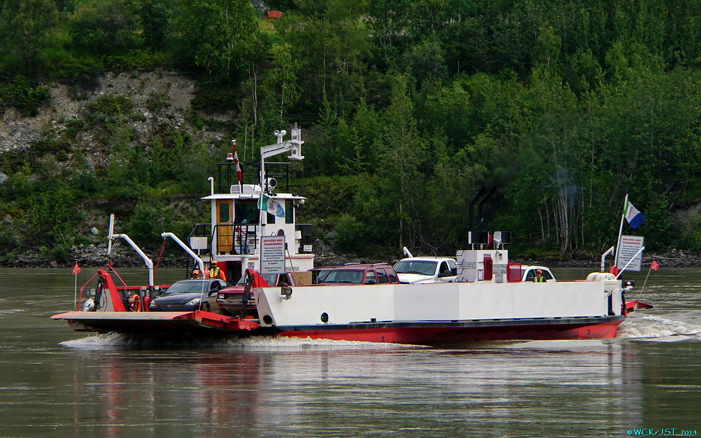
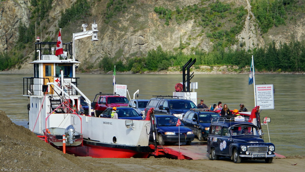
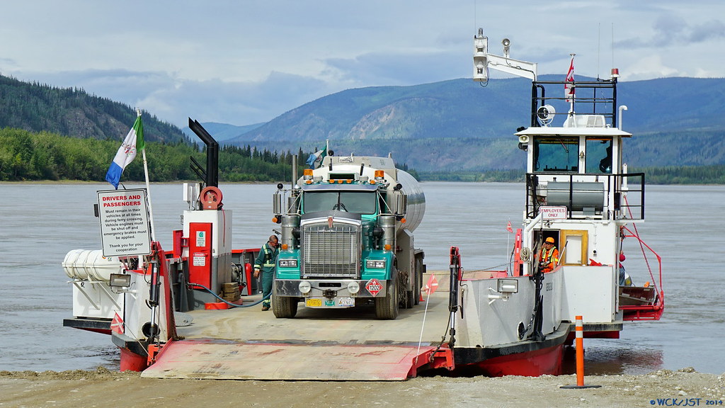
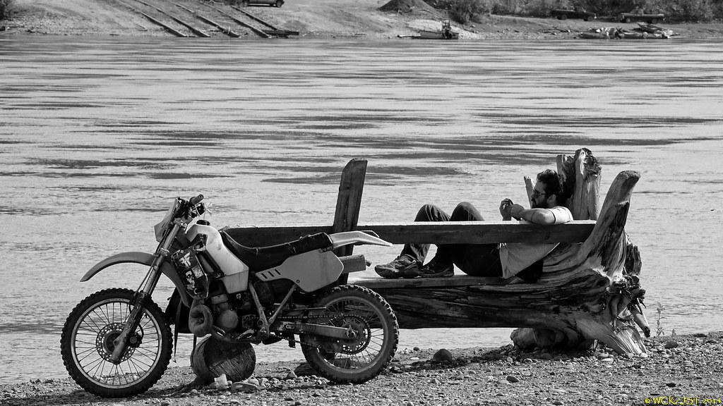
Yukon River Ferry George Black shown crossing the Yukon @ Dawson City - 15 August 2014. This connects the Klondike Highway (Yukon Hwy 2) with the 'Top of the World' Highway (Yukon #9). She carries a steady parade of RV's & motor homes across the river 8 AEQ's at a time. At this time of year the capacity is inadequate. I will feature more photos & commentary later when I return home. Neil would love the foot passenger facilities....  © WCK-JST by Wett Coast, on Flickr © WCK-JST by Wett Coast, on Flickr
|
|
Koastal Karl
Voyager   Been on every BC Ferry now!!!!!
Posts: 7,747
|
Post by Koastal Karl on Aug 16, 2014 10:01:51 GMT -8
They probably have no foot passengers at all. Why would they? It's in the middle of no where unless your hitchhiking, lol! Do they at least have a washroom onboard?
|
|
|
|
Post by WettCoast on Aug 16, 2014 10:38:27 GMT -8
Five sailing wait for 'over lengths'... Attachments:
|
|
|
|
Post by Low Light Mike on Aug 16, 2014 10:58:59 GMT -8
Five sailing wait for 'over lengths'... I see that they're using berth #1 in this photo. If they move enough dirt, they can shorten the crossing. |
|
Koastal Karl
Voyager   Been on every BC Ferry now!!!!!
Posts: 7,747
|
Post by Koastal Karl on Aug 16, 2014 11:40:48 GMT -8
I think that first truck and trailer would take up pretty much the whole ship, lol! Plus maybe a few cars. How long is the crossing??
|
|
|
|
Post by Starsteward on Aug 17, 2014 10:34:25 GMT -8
Five sailing wait for 'over lengths'... I see that they're using berth #1 in this photo. If they move enough dirt, they can shorten the crossing. If the answer to the 'washroom' question is a negative, Mr. Horn's dirt moving suggestion might garner a few votes.  |
|
|
|
Post by WettCoast on Aug 19, 2014 6:41:47 GMT -8
|
|
|
|
Post by northwesterner on Aug 20, 2014 21:11:16 GMT -8
When I worked for HAP Alaska Yukon (the big bus company whose corporate heritage has become increasingly foggy) in 2010 as the Skagway safety manager, we regularly used this vessel to get our coaches into Dawson for a few weeks. Traditionally the Yukon/Klondike over the road tour used a set of coaches from Fairbanks to Eagle on the Taylor highway, the owned Yukon Queen (tied up at Fisherman's Terminal in Seattle this summer) to get the pax downstream to Dawson, and a separate set of coaches from Dawson to Skagway. In 2010 all this was operated out of Fairbanks, with vehicles rotated in Skagway back to Fairbanks via the Alaska Highway tour. Due to bridge out on the Taylor highway we rerouted the tour via the Top of the World Highway. Get this ... we could fit two loaded 45ft motorcoaches side by side on that ferry. This continued until a slide closed the Top of the World and we started flying the guests from Tok to Dawson. The tour pattern changed this year after decades of "same same" ... the over the road trip from Fairbanks to Dawson is gone, replaced by a regular charter flight. The Alaska Highway tour is gone, too. |
|
|
|
Post by Low Light Mike on Aug 20, 2014 21:25:33 GMT -8
I like the vehicle that is first to disembark. Seems out of place in that part of the country... Or is it a Yukon taxi or a tour company car? |
|
|
|
Post by WettCoast on Aug 21, 2014 7:06:00 GMT -8
That vehicle is European (Netherlands, I think), & participating in a rally called the Pan Americana. Take a look at the full size version of that pic by linking to it on Flickr. I saw at least three of these rally cars. See: www.indiantrail.nl/homeWCK, Whitehorse |
|
|
|
Post by WettCoast on Aug 28, 2014 14:39:44 GMT -8
|
|
|
|
Post by WettCoast on Sept 1, 2014 22:48:13 GMT -8
|
|


