D'Elete BC in NJ
Voyager   Dispensing gallons of useless information daily...
Posts: 1,671
|
Post by D'Elete BC in NJ on Dec 28, 2008 6:41:58 GMT -8
|
|
Mill Bay
Voyager   Long Suffering Bosun
Posts: 2,887 
|
Post by Mill Bay on Dec 28, 2008 16:58:10 GMT -8
Alright, I admit i missed the boat on this one, seeming as I actually live in Chilliwack. There was, for a long time from at least 1901 onwards, a ferry that crossed the Fraser River between Chilliwack (Rosedale) and Agassiz, until a bridge was built in 1956. The span of the bridge is approximately 2 km although the river itself is not that wide... the bridge also crosses a broad swath of floodplain located outside the protective dikes. As the archival pictures show, the ferry went through several phases in its life as traffic types changed with each era. I remember seeing one picture of it with a vessel running that much resembled the T'lagunna pioneer of the Albion ferry run. The ferry was tolled after it became a part of the provincial highways in the 1950s, as was the bridge for some time after it replaced the ferry. Incidentally, I just overheard some friends discussing ice on the Fraser and they confirmed that in the winters, ice floes could occasionally put the ferry out of service and, if the ice was solid enough, people would even risk driving across in buggies and even vehicles on the ice. Satellite photo shows the location of the current crossing, as well as evidence in local naming that refers to the ferry. I don't know the specific route the ferry ran on, and I don't believe there are any physical remains today, apart from the road that led to whatever point the landing was at. Apart from ferries, the Fraser also supported much stern wheeler traffic and, although I had never heard of the Empress of Chilliwack which ran on Harrison Lake, there was steamer service that ran the length of Harrison Lake to a way point at its northern end called Port Douglas (after James Douglas), then followed a series of wagon roads and water routes along Lillooet Lake to Mt Currie and then along Seton and Anderson Lakes to Lillooet and up the Fraser Canyon to the goldfields. This route was a precursor too, and a short-lived alternative route for the Cariboo Wagon road built during the gold rush times. (If I get a chance, I might try to go to the city archives and see if there is any good material on the ferry operations there.) |
|
Neil
Voyager  
Posts: 7,309
|
Post by Neil on Dec 28, 2008 21:08:11 GMT -8
D'Elete: Thanks for that Chilliwack Museum link; some fascinating photos there. Never seen or heard of the Sea Wolf before. Just about as basic as a car ferry can be. What a neat little boat.
Mill Bay: The T'Lagunna did run on the Agassiz - Rosedale route when it was first built. Then it went to the Ladner- Richmond route before doing another stint at Agassiz, and ended up at Albion. Another Agassiz - Rosedale boat was the Eena, which ended up at Gabriola Island, preceding the Westwood (Albert J. Savoie).
|
|
|
|
Post by fargowolf on Jan 15, 2009 10:04:17 GMT -8
Speaking of inland waterways, Does anyone know where I could find pics of the Okanagan Lae ferries that ran between Kelowna and Westbank.
|
|
Nick
Voyager   Chief Engineer - Queen of Richmond
Posts: 2,080 
|
Post by Nick on Jan 15, 2009 10:28:47 GMT -8
|
|
|
|
Post by Low Light Mike on Jan 15, 2009 10:30:23 GMT -8
Speaking of inland waterways, Does anyone know where I could find pics of the Okanagan Lae ferries that ran between Kelowna and Westbank. Check out this thread: ferriesbc.proboards20.com/index.cgi?action=display&board=qa&thread=4424&page=1(Nick beat me to it, re the link. When I found it, I decided to move it to the historical section, since the Pendozi & friends are no longer running on the lake....) |
|
|
|
Post by Low Light Mike on Dec 4, 2009 12:43:37 GMT -8
Here's something that Neil posted today in the current Inland-ferries thread, and it's relevant to this thread too, so here's a copy: Not much of a photo, I realize, but this is the Jacob Henkel, predescessor to the Omineca Princess. 1984.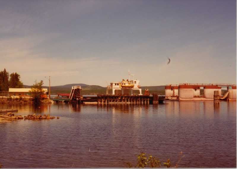 Omineca Princess, same year. Omineca Princess, same year.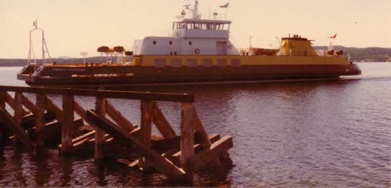 |
|
Mill Bay
Voyager   Long Suffering Bosun
Posts: 2,887 
|
Post by Mill Bay on Dec 4, 2009 13:00:10 GMT -8
Not much of a photo, I realize, but this is the Jacob Henkel, predescessor to the Omineca Princess. 1984. Just on a whim, I thought if I could find any other pictures of this ferry and, by chance, I came up with this photo in an online postcard collection of old ships. www.photoship.co.uk/JAlbum%20Ships/Old%20Ships%20J/slides/Jacob%20Henkel-01.htmlWhat I can't understand is how they went from this, to the Omineca Princess to the current barge. At least the previous ferries actually looked like ships and had a recognizable top and bottom. The Forrester is so ugly and lopsided, it looks like maybe it's running upside down, with it's keel sticking out the water and the actual superstructure underneath. Someone needs to go up and flip it over so the proper side is above the water. |
|
Neil
Voyager  
Posts: 7,309
|
Post by Neil on Dec 7, 2009 19:34:32 GMT -8
Two of the Anscomb. 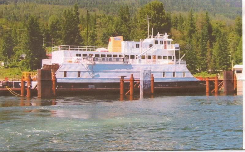 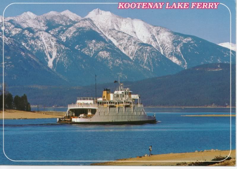 -E. Anderson photo. |
|
|
|
Post by lmtengs on May 1, 2010 18:42:35 GMT -8
I've been wondering for the longest time if there was anything left of the old Pitt Meadows Ferry Terminal on the Pitt River, which, before the first bridge was built in 1958, ran between Pitt Meadows and Port Coquitlam. I never really knew of the EXACT location of the ferry, and just assumed it was between the two old swing bridges. Well, we bought a new map book yesterday, and lo and behold, I see Ferryslip Road. It was not in my old map book, and not viewable in Google maps unless you were viewing one of the closest zoom levels. I'm not sure if there's anything left of the Port Coquitlam Terminal, but I'll check later this year. Here's what I found at the old Pitt Meadows Ferry slip: Here's the location on Google Maps: MAP LOCATIONProof of a Ferryslip road:  As you can see, it's a narrow little street. This photo is looking East, away from the River.  What appears to be the old holding compound is full of landscaping materials to be used with the new Pitt Bridge.  More of the holding compound:  Could this be what remains of the old cable-ferry? I remember reading that it only ever held one car at a time, and this looks like, with a wooden deck on top, it could easily do so. On the google map link i've provided, you can clearly see it in the lower corner of the bay. The little red thing in the holding compound in the map appears to be a car, so using size as the evidence, it's very plausible that the thing could've been the ferry.   This is what remains of the causeway on which you would have driven to get onto the ferry.  The pavement is very cracked since it hasn't been paved in over fifty years.  On the causeway, looking towards the compound:  This is the little 'bay' that the 'ferry' is sitting in. I'm not sure what it's use was, but it's a little bit cool.  I think i'm gonna stop by in the summer with some hedge clippers to try and clear away a few of the prickles so I can get closer to the little bargey-ferry thingy, and so I can check out what's at the end of the causeway. And a few bonuses, starting with the footings of the old 1958 bridge beside the new bridge.  The bridge deck:  |
|
Mill Bay
Voyager   Long Suffering Bosun
Posts: 2,887 
|
Post by Mill Bay on May 3, 2010 14:07:42 GMT -8
Wow! It doesn't take them long to destroy anything anymore, does it? I'm going to miss the old swing bridges just because they had so much uniqueness to their operation. Still having trouble believing that that new bridge actually has the height to clear the navigation channel, but I guess it's not as if they expect a cruise ship going up the Pitt River.
That spot looks very much like the former Fraser River crossing out near Rosedale in Chilliwack, although there is even less evidence of the ferry operation there, aside from a roadname just like there. I would hazard a guess that the oldest road that is all overgrown might still be left over from the ferry, but most of the other areas look too new in their construction to still be remnants from that time. They are likely just later construction related to the industry in that spot.
|
|
|
|
Post by lmtengs on May 3, 2010 14:21:38 GMT -8
I would hazard a guess that the oldest road that is all overgrown might still be left over from the ferry, but most of the other areas look too new in their construction to still be remnants from that time. They are likely just later construction related to the industry in that spot. There has been no industry in that location since the ferry ended service, except for recently when they started storing those bridge constuction materials there. Up until then that area was barred from vehicle traffic (see the gate in the picture of Ferry Slip Road) I believe that maybe that the ex-compound may have been maintained longer than the ferry slip itself as an emergency crossing. I have no evidence to prove that though, except for the not-so-decrepit pavement where the landscaping material is. |
|
Neil
Voyager  
Posts: 7,309
|
Post by Neil on May 3, 2010 16:32:55 GMT -8
Your history might be off by a good forty years. I had never heard of a ferry connecting Pitt Meadows in 1957, and according to this history... www.mapleridge.ca/EN/main/residents/569/history.html... the first bridge actually opened in 1913. Perhaps the first bridge was a humble little affair like the present Westham Island bridge. |
|
|
|
Post by lmtengs on May 3, 2010 18:12:33 GMT -8
Your history might be off by a good forty years. I had never heard of a ferry connecting Pitt Meadows in 1957, and according to this history... www.mapleridge.ca/EN/main/residents/569/history.html... the first bridge actually opened in 1913. Perhaps the first bridge was a humble little affair like the present Westham Island bridge. The district of Maple Ridge's Website is not looked fondly upon by our city's citizens, due to easily viewable errors like these. I recommend you look at the City of Pitt Meadows website history section, and scroll down a bit: www.pittmeadows.bc.ca/EN/main/residents/43/754.htmlAnd to correct Maple Ridge's website, River Road, which connected to Old Dewdney Trunk Road via 203rd Street, WAS built in 1913, but it connected to the ferry until 1957 ( I was off by one year  ), when the original span of the swing bridge was completed. In the 1970's, the north span was added, and in 2009, the big bridge replaced them both. Also, Port Coquitlam's website mentions a Lougheed Highway "hook-up" in the 1950s... It's good to have people like Niel around on the forum to make sure people are correct with what they post. *applause*  EDIT: And yes, the first bridge WAS and still IS a humble affair. It's the CPR railway bridge, which never to my knowledge carried vehicular traffic. |
|
Mill Bay
Voyager   Long Suffering Bosun
Posts: 2,887 
|
Post by Mill Bay on May 3, 2010 22:01:52 GMT -8
On another note: Cross posting an article about another long retired ferry crossing at what is now the Deas Island Tunnel, and don't blow a fuse if I didn't call it the Massey Tunnel. Just stumbled across an article about the history of the Saltspring Queen/Delta Princess before she was displaced by the tunnel. Tunnel sends river ferry to drydock35-minute sailing across Fraser replaced by five-minute drive Sandor GyarmatiDelta Optimist Saturday, May 23, 2009The opening of the long sought after Deas Island Tunnel began a new era in Delta, but brought another to an end. When the Fraser River crossing opened on May 23, 1959, it marked the final day of service for a Ladner ferry that had been operating for almost five decades. The Delta Princess completed its last crossing of the Fraser between Ladner and Woodward's Landing that day. Travel time between the two municipalities was cut from the approximately 35 minutes taken by the sternwheeler ferries to just five minutes through the tunnel, the Delta Optimist reported at the time. The community got its ferry service after ratepayers petitioned the reeve and council for a bridge near Deas Island. The New Delta, a propeller-driven, steam-powered vessel that made round trips between Ladner and Steveston, provided ferry service from 1910 to 1913. The Sonoma replaced it in 1913. Provided by the Department of Public Works, service between Ladner and Woodward's Landing started on a regular basis in November 1914 with the Helen M. Scanlon. To honour Delta's first reeve, the name changed to the William Henry Ladner in early 1915, when Capt. James Herrling assumed command. The vessel would later be replaced by another sternwheeler, the SS Beaver, which had a greater carrying capacity for cars and passengers. The Beaver was succeeded by the Ladner-Woodwards No. 3, then by the motorship Agassiz, and finally by the Delta Princess. Launched in May 1949, the Delta Princess had a capacity of 35 cars and a speed of 12 knots. The original ferry landing was located at the foot of Delta Street, behind where Sharkey's restaurant is now located at Ladner Harbour. The landing was later moved to another spot in the harbour, across the street from the Riverview Hotel, before eventually moving to the foot of Ferry Road, which cut the sailing time to Richmond. The ferry service had several captains with D.O. Morris in charge for the historic final trip in 1959. On that trip, the ferry took a capacity load of cars and 200 people. The Ladner Band, on a low-bed truck loaned by Delta Freight Lines, even provided tunes. Herrling was also on that last sailing, greeting 88-year-old Harry Mills, who was one of the first deckhands when the Ladner ferry service began. Edgar Dunning, who was publisher and editor of the Optimist at the time of the last trip, recalls lengthy weekend lineups for the ferry as well as motorists having to go all the way around through New Westminster if they missed the final sailing of the day at 11 p.m. "It wasn't a nice drive when it was foggy, I can tell you that," he says. Longtime South Delta resident and retired high school principal Bill Kushnir, George Massey's son-in-law, says a few here viewed the idea of a tunnel to replace the ferry as a fantasy. "George Massey was seen as kind of an oddball and was even called a crazy Irishman. But he just had that kind of personality and didn't stop. I'm very proud of him. He never got any personal gain other than personal satisfaction," Kushnir says. The Delta Board of Trade also frustrated Massey and he became so disillusioned that he left the organization. That's because the Acme Operating Company, the company running the ferry, influenced the board says Doug Massey, George's son. "He left them and the (Lower) Fraser Crossing Association split to become its own independent group," he says. "It wasn't easy for my father but he kept on going and didn't give up. He did a lot of traveling and a lot of research and talked to so many people about it. He had the calculations so they couldn't argue with him that it couldn't be done, and he even drew maps." All seemed forgiven by the time the tunnel opened as the board of trade named George Massey its Citizen of the Year in 1959. After its final trip here in 1959, the Delta Princess went to drydock in Vancouver for a few days before Capt. Morris took it to a run in the Gulf Islands. © Delta Optimist 2009 |
|
Neil
Voyager  
Posts: 7,309
|
Post by Neil on May 3, 2010 22:15:47 GMT -8
And yes, the first bridge WAS and still IS a humble affair. It's the CPR railway bridge, which never to my knowledge carried vehicular traffic. I think you misread the Pitt Meadows site. It says a highway bridge was built in 1957. As Paul's post confirms, the piece I linked to was correct- cars were travelling over a bridge to Pitt Meadows in 1913, or 1914 at the latest. It looks likely to have been one way at a time, as is the Westham bridge. |
|
|
|
Post by lmtengs on May 4, 2010 14:37:05 GMT -8
I learned something today  |
|
|
|
Post by Low Light Mike on Jul 29, 2010 21:02:10 GMT -8
Not much of a photo, I realize, but this is the Jacob Henkel, predecessor to the Omineca Princess. 1984. The Jacob Henkel has been cut-down to become a barge, and is tied up beside the South-side ferry dock of Francois Lake. During my Francois Forrester ferry-ride earlier this month, I asked a crew-member about the Jake-barge, and he said that someone just recently purchased it. Here are my pictures from July 17, 2010 of the Jake on the lake: The location: - she's on the right-side of the picture. 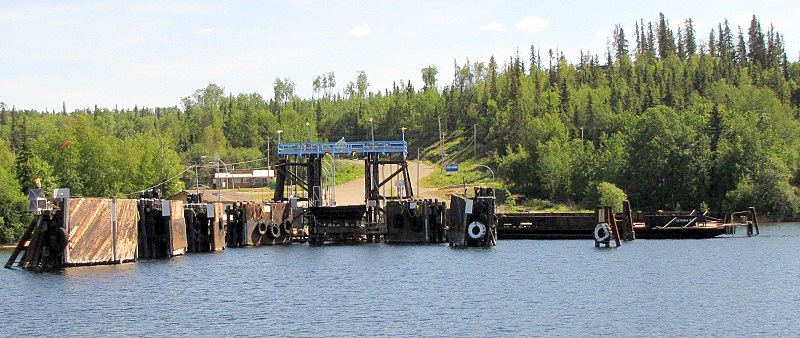  Close-ups: 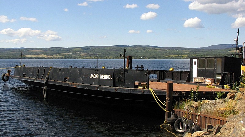  3-lane car-deck 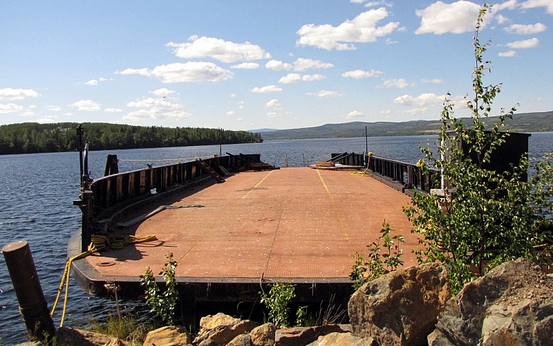 |
|
|
|
Post by Low Light Mike on Nov 27, 2010 15:27:39 GMT -8
|
|
|
|
Post by Low Light Mike on Nov 28, 2010 21:24:23 GMT -8
From an archived 2006 post done by member Retro: - I'm thinking this is the Anscomb, photographed from someone on the MV Balfour. ============ From this map:  |
|
|
|
Post by Low Light Mike on Jan 12, 2012 8:53:11 GMT -8
On sale at EBay - this postcard  |
|
|
|
Post by Low Light Mike on Feb 18, 2012 21:07:10 GMT -8
|
|
|
|
Post by WettCoast on Apr 4, 2012 22:58:46 GMT -8
Another from the camera of Mr. DOT... M/V Anscomb near Balfour, Kootenay Lake, BC - circa August 1999. This vessel was retired in the following year when the new Osprey 2000 entered service. A few years later (2004 to be exact), the Anscomb sank near Ainsworth Hot Springs.  photo © Mr. DOT photo © Mr. DOT by Wett Coast, on Flickr[/size] |
|
mrdot
Voyager   Mr. DOT
Posts: 1,252
|
Post by mrdot on Apr 5, 2012 9:06:01 GMT -8
:)note the jury rigged bow and stern deck ramps in order to fit the new docks on Kootenay lake improved for the new ferry! did many trips over to crawford bay in the summer! mrdot.  |
|
Neil
Voyager  
Posts: 7,309
|
Post by Neil on Apr 5, 2012 19:52:36 GMT -8
Very nice shot of the Anscomb, with the verdant mountains behind... wish I could have ridden that boat- the one time we were up that way, we were on the Balfour.
She was kind of a cross between Queen of The Islands, with a bit of Tachek and maybe Quillayute thrown in; I think, the nicest looking car ferry in the interior.
|
|