|
|
Post by compdude787 on May 29, 2013 9:36:29 GMT -8
OSM was actually the first to remove the collapsed bridge; in fact someone beat me to it, as several hours had passed before I heard about the bridge collapse. Unfortunately, many of us mappers were quite annoyed that Google Maps was getting all the credit for "quickly" removing the bridge when OSM had really done it first. |
|
|
|
Post by Steve Rosenow on May 29, 2013 15:31:07 GMT -8
Question for Americans regarding this bridge & Interstate highways in general. Which level of government is responsible for their maintenance & improvement - the US federal government or individual states (or maybe even local counties/cities/towns)? It is my understanding that the Interstate network was funded (at least partially) by the US federal government. If it is determined that this type of through truss 60 year old bridge has to go, and all Interstate bridges of the type must be replaced, who pays? The states are respnsible for maintenance and improvements for highways and Interstates, but the federal government often provides some funding to a state for highway construction. Not necessarily true. About 10-20 percent of the budget for interstate highway maintenance and upgrades at the state level comes from the federal gas tax. If it's a U.S. Highway or an Interstate freeway, there's federal dollars affixed to its maintenance. Washington State has a 10-cent tax on each gallon of gas sold, and that tax was mandated after I-695 cost the state nearly two billion dollars in annual revenue to fund the maintenance of our own roads and bridges. |
|
|
|
Post by Steve Rosenow on May 29, 2013 15:36:59 GMT -8
OSM was actually the first to remove the collapsed bridge; in fact someone beat me to it, as several hours had passed before I heard about the bridge collapse. Unfortunately, many of us mappers were quite annoyed that Google Maps was getting all the credit for "quickly" removing the bridge when OSM had really done it first. To my knowledge, KIRO TV was the first media outlet to report the removal of the bridge on Google Earth/Google Maps via their Facebook page, and if I can recall, that happened within the first twenty minutes of the initial failure. |
|
|
|
Post by compdude787 on May 29, 2013 17:07:14 GMT -8
The states are respnsible for maintenance and improvements for highways and Interstates, but the federal government often provides some funding to a state for highway construction. Not necessarily true. About 10-20 percent of the budget for interstate highway maintenance and upgrades at the state level comes from the federal gas tax. If it's a U.S. Highway or an Interstate freeway, there's federal dollars affixed to its maintenance. Washington State has a 10-cent tax on each gallon of gas sold, and that tax was mandated after I-695 cost the state nearly two billion dollars in annual revenue to fund the maintenance of our own roads and bridges. Okay, what I'm saying is that the state actually does the construction/ maintenance, while the federal government just provides a good chunk of funding. I wasn't saying that the state has to fund everything on its own without any money provided by the other Washington. |
|
|
|
Post by Mike C on May 31, 2013 10:54:23 GMT -8
A great example of when agencies, companies, and organizations come together to make things happen (very rare): Amtrak, BNSF, WSDOT and Sound Transit have cooperated to implement a third roundtrip on Amtrak Cascades between Bellingham and Seattle, in order to accommodate more customers after the bridge collapse. I will be traveling down to the US tonight on Amtrak, and the cost was higher to Seattle, then when I went to Portland, OR in February, due to high demand for the rail service. The new round-trip was effective today. More: www.wsdot.wa.gov/News/2013/05/31_NewAmtrakCascadesTrainsSeattleToBellingham.htm |
|
|
|
Post by Mike C on Jun 17, 2013 12:35:12 GMT -8
WSDOT has posted new photos of the temporary span for your viewing enjoyment - it sounds like it will be ready for traffic by the end of the week: www.flickr.com/photos/wsdot/ |
|
|
|
Post by WettCoast on Jun 17, 2013 20:31:53 GMT -8
WSDOT has posted new photos of the temporary span for your viewing enjoyment - it sounds like it will be ready for traffic by the end of the week: www.flickr.com/photos/wsdot/The temporary spans look a lot like a 'Bailey bridge' - en.wikipedia.org/wiki/Bailey_bridge. Will the permanent replacement bridge be a complete new crossing of the Skagit River or just a replacement of the collapsed span? |
|
SolDuc
Voyager  West Coast Cyclist
SolDuc and SOBC - Photo by Scott
West Coast Cyclist
SolDuc and SOBC - Photo by Scott
Posts: 2,055
|
Post by SolDuc on Jun 17, 2013 20:42:05 GMT -8
WSDOT has posted new photos of the temporary span for your viewing enjoyment - it sounds like it will be ready for traffic by the end of the week: www.flickr.com/photos/wsdot/The temporary spans look a lot like a 'Bailey bridge' - en.wikipedia.org/wiki/Bailey_bridge. Will the permanent replacement bridge be a complete new crossing of the Skagit River or just a replacement of the collapsed span? After it was said on one of the earlier weekend flickr photos that the temporary span would only last for three months, I went on the DOT page and found out that unfortunately they were not rebuilding the whole bridge, but rather the missing span, which they will build on site then install, a process which should close the bridge for another two weeks. I guess there is going to be quite a fuzz when everyone finds out that they are not replacing the whole bridge. Anyways, I hope that once the new, more definitive plan will be in place the DOT will build one 6-lane bridge (or two 3-lane bridges) to replace the old one and bring that part of I-5 up to standards. |
|
SolDuc
Voyager
West Coast Cyclist
SolDuc and SOBC - Photo by Scott
Posts: 2,055
|
Post by SolDuc on Jun 18, 2013 15:25:15 GMT -8
Update: the temporary bridge opens tomorrow.
|
|
|
|
Post by Political Incorrectness on Jun 18, 2013 21:04:47 GMT -8
WSDOT has posted new photos of the temporary span for your viewing enjoyment - it sounds like it will be ready for traffic by the end of the week: www.flickr.com/photos/wsdot/The temporary spans look a lot like a 'Bailey bridge' - en.wikipedia.org/wiki/Bailey_bridge. Will the permanent replacement bridge be a complete new crossing of the Skagit River or just a replacement of the collapsed span? From what I understand, it is going to replace the collapsed section. There would be a massive cost to replace the entire span and require a realignment of I-5 on the approaches. |
|
FNS
Voyager
The Empire Builder train of yesteryear in HO scale
Posts: 4,952
|
Post by FNS on Jun 19, 2013 11:11:48 GMT -8
|
|
FNS
Voyager
The Empire Builder train of yesteryear in HO scale
Posts: 4,952
|
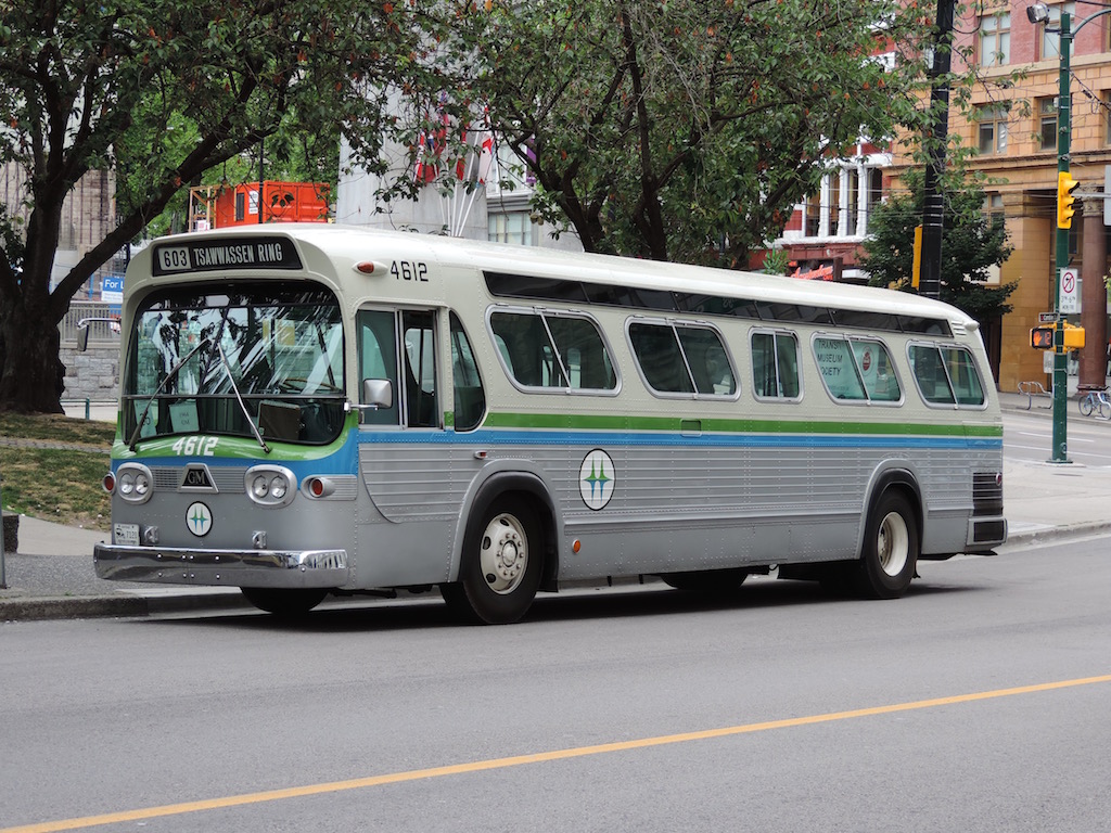
Post by FNS on Sept 15, 2013 11:08:40 GMT -8
The bridge as seen aboard an Amtrak Thruway bus on the afternoon of Saturday, September 14, 2013 after attending an Open Ship aboard an Alaska ferry in Bellingham: 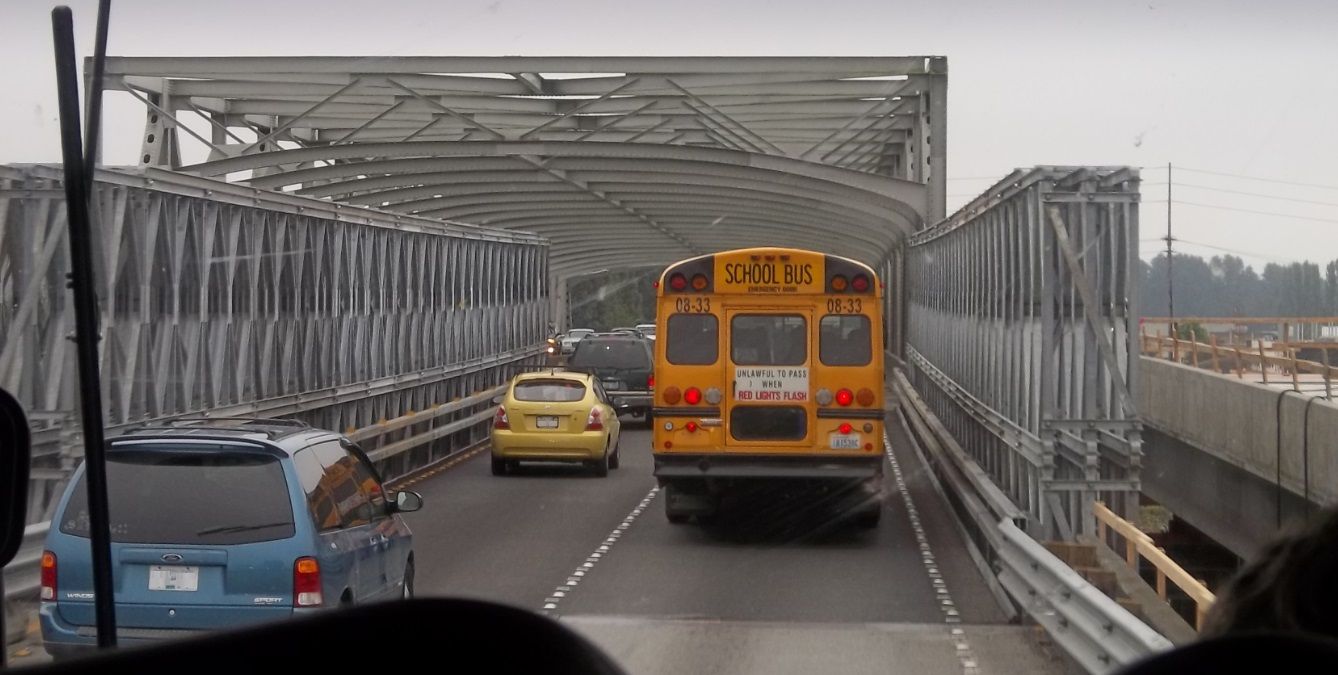 |
|
SolDuc
Voyager
West Coast Cyclist
SolDuc and SOBC - Photo by Scott
Posts: 2,055
|
Post by SolDuc on Sept 15, 2013 13:34:18 GMT -8
The bridge as seen aboard an Amtrak Thruway bus on the afternoon of Saturday, September 14, 2013 after attending an Open Ship aboard an Alaska ferry in Bellingham: I realized this morning that the permanent bridge replacement was rolled into place overnight and that the temporary bridge is now retired. That means that you (and I as well, for that matter) were among the last to cross the temporary bridge. |
|
|
|
Post by Blue Bus Fan on Sept 15, 2013 15:30:41 GMT -8
Do you know if WSDOT is going to remove the trusses on this bridge? I think I heard it on the news; this will prevent the bridge from collapsing again.
|
|
SolDuc
Voyager
West Coast Cyclist
SolDuc and SOBC - Photo by Scott
Posts: 2,055
|
Post by SolDuc on Sept 15, 2013 15:42:45 GMT -8
Do you know if WSDOT is going to remove the trusses on this bridge? I think I heard it on the news; this will prevent the bridge from collapsing again. The trusses will be removed and straight new ones will be put in place, from what I understood based on this. Photo from the WSDOT Flickr stream. CC Liscence.  Portal Before/After Images Portal Before/After Images by WSDOT, on Flickr |
|