|
|
Post by Scott on Mar 9, 2007 19:46:21 GMT -8
I know this topic has been discussed before in various places, but it never gets old:) And there are more people on the forum now, so we can get even better ideas of where to watch ferries and get great photos from.
My favorite place is probably the Bluffs on Galiano Island. Along with beautiful views of the Gulf Islands you get a birds-eye view of ferries in Active Pass. Someday I'd like to go up mount Galiano... the view is probably 10 times better - if it's possible!
Almost as good is Newcastle Island. The only problem is that there are only a few ferries going by. Another favorite is the bluffs over Horseshoe Bay that at least a few of you guys have discovered as well:)
I do have one question as well. Are there any "legal" ways to get Deas Island photos? And if not, let's hear the illegal ones;)
|
|
|
|
Post by WettCoast on Mar 9, 2007 22:15:07 GMT -8
Would it not be fairly easy to get to Helen Point, Mayne Island from Village Bay? I would think that the ferry spotting there would be quite decent. The land there is 1st Nations reserve.
Another spot that I was at two spring breaks ago was Ruckle (sp?) Park on Salt Spring Island. Well worthwhile it was.
Another spot would be the point at the entrance to Horseshoe Bay. My map says that it is named Tyee Point. It may all be private high priced West Van real estate and unreachable, legally anyways.
|
|
|
|
Post by WettCoast on Mar 9, 2007 22:46:54 GMT -8
Regarding ferry spotting at Horseshoe Bay... There must be some good opportunities on nearby hills and points as shown on my map below. I think that Tyee Point and the 120 metre high hill in behind it might be excellent vantage points. Those of you living nearby might know more about the possibilities there. 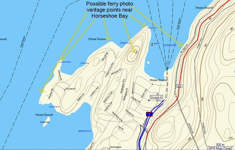 |
|
D'Elete BC in NJ
Voyager   Dispensing gallons of useless information daily...
Posts: 1,671
|
Post by D'Elete BC in NJ on Mar 10, 2007 4:55:06 GMT -8
Copper Cove (middle arrow beside "Howe Sound") can be accessed by a trail well known by local divers. It's a good spot for Island bound ferry traffic. See the following site for directions. www.shorediving.com/Earth/Canada/Vancouver/Copper_Cove/index.htmIf you look at the initial photo on the website, you want to head toward the steep rocky area to the left. Good vantage points can be found from here. Parking was very limited the last time I was there and fills up early. Parking outside the designated areas will likely lead to having your car towed... some of the locals don't appreciate the company.  |
|
|
|
Post by Ferryman on Mar 10, 2007 9:00:44 GMT -8
On the day of our Bowen Queen/Bowen Island adventure, I went off to see if I could find an awesome viewpoint from the mountain on the west side of Horseshoe Bay. I had looked at what roads to turn at on Google Earth the night before, and I had thought I found a fairly visible trail. The next day when I got there, I found two signs. One said, (right beside a driveway, which looked like some sort of city access to the peak of the mountain) "Private Drive, No Tresspassing, Strictly enforced!". The next sign, just 10 feet to the right of that sign, against a fairly well used trail said, " Keep off trail, steep slippery rocks!". Oh well, maybe when Spring finally rolls around  . |
|
|
|
Post by Scott on Jun 23, 2008 21:10:38 GMT -8
How easy is it to access Sugarloaf Mountain in Nanaimo? Is it an actual park with a parking lot and sign, etc.? I know some members on the forum have been there and I think I asked this question before, but I couldn't find the answer when I searched this evening. I was quite impressed with some of the photos taken from there recently.
|
|
|
|
Post by Ferryman on Jun 23, 2008 21:45:21 GMT -8
Ah! Good ol' Sugarloaf. A family favourite spot in Nanaimo for me, which I've visited countless times while I was growing up. I remember sitting up there watching the HMCS Cape Breton sink just off Snake Island, and being jealous of everyone who spent the $$ to hop on to the Queen of Coquitlam to get up close and personal with the sinking.
Sugarloaf Mountain is in fact quite easy to access. There's no parking lot for it, but there is a sign at the beginning of the long staircase you follow to reach the top. The only access point I'm aware of, is at the cul de sac at the end of Marion Way. Type in Marion Way on google maps, and it should show up. I wouldn't recommend having the wife bring the stroller for the little ones, as the trail is 95% stairs. Good luck!
|
|
|
|
Post by Nucksrule on Jun 25, 2008 20:39:08 GMT -8
Albeit only for the HB-DB ferry, there are great views of the entrance to Howe Sound from Timberfield road and the surrounding trails in Caulfield, West Vancouver. On a sunny day the ferries look gorgeous over the water.
|
|
|
|
Post by Curtis on Aug 22, 2008 10:38:05 GMT -8
I'm in Vancouver next week so I'm wondering about some good viewing points for...
1, Deas Dock to try and get one last look at (and photo-shoot of) the Queen of Esquimalt.
2, Burrard Drydock for looking at the New West and I-Sky.
I was wondering where these view points are and the directions to get there.
|
|
|
|
Post by Canucks on Aug 22, 2008 11:01:03 GMT -8
For Deas Dock you could try Deas Island Regional park. I'm not sure how good the view is but you might be able to see her. It is located on River Rd. If you come from Tsawwassen then just take hwy 17 and just past 99 it will change into 62B st. Then there should be a turn off for Deas park on the left hand side a short way down the road. If you are coming from Horseshoe Bay it is pretty confusing. Best to look at Google maps. For Burrard Drydock you can check here. Forum member Alberni provided this map of the area. ferriesbc.proboards20.com/index.cgi?board=photos&action=display&thread=2967&page=45 |
|
|
|
Post by Curtis on Aug 22, 2008 17:13:47 GMT -8
Thanks for the info. If anybody else knows of other areas for viewing please post.
Could somebody post directions and the risks of using the spot along the railroad tracks that forum members have used in the past? Much Appreciated if done!
|
|
|
|
Post by Canucks on Aug 24, 2008 21:14:02 GMT -8
Could somebody post directions and the risks of using the spot along the railroad tracks that forum members have used in the past? Much Appreciated if done! I am not sure what you mean by spot along the tracks. Do you mean walking down them or just driving along the tracks and jumping out when you see a train? |
|
|
|
Post by Curtis on Aug 24, 2008 21:25:03 GMT -8
Could somebody post directions and the risks of using the spot along the railroad tracks that forum members have used in the past? Much Appreciated if done! I am not sure what you mean by spot along the tracks. Do you mean walking down them or just driving along the tracks and jumping out when you see a train? You reach this spot by "Walking" along the tracks. |
|
Nick
Voyager   Chief Engineer - Queen of Richmond
Posts: 2,080 
|
Post by Nick on Aug 24, 2008 22:36:52 GMT -8
I think SR-16 was referring to the tracks that are right next to Deas Dock, as some members have used them in the past to get photos of ships sitting at Deas. Personally, I'm not familiar with them or how to access them, but perhaps someone else might. If I recall correctly, I think they are CN's tracks, and I don't think that they really like people messing around there. However, if you are careful, you might be able to get away with it.
|
|
|
|
Post by Canucks on Aug 24, 2008 22:54:44 GMT -8
Ok, a big DUH! after I reread the post. Strange I interpreted it as "spotting along the railroad" but anyway...  well the track right next to Deas dock looks to be a spur line of some sort for a car lot at the end of the tracks. It did look to be active as there was a train on it when I looked in Google Earth. If you do go there just remember that "Anytime is train time". I hope you get some neat shots too! |
|
|
|
Post by Curtis on Aug 24, 2008 23:34:25 GMT -8
Well thanks for the help...I think. The only thing I need to worry about now is when the trains come along the track. I have to either guess or Ask the Audience. (Phone a Friend and 50/50 won't work here)
|
|
|
|
Post by Ferryman on Aug 25, 2008 7:02:17 GMT -8
Well Ship Rider, trying to find a great vantage point at Deas is quite risky. In order to do so, you must enter private property. Not only do you have to look out for trains, but you must look out for rent a cops as well, who won't hesitate to call the police on you. Just so our little routings don't get spoiled after being revealed to the public eyes of the internet, I'll at least let you know the best way of going there. Try turning off at the Deas facility on Rice Mill Road, and heading along the road towards the site. This road takes you to a parking lot, and along the way, you get to see the ships in the dock head on, as you drive down this road. Remember, if you go straight, it will take you right into the parking lot for all of the workers. There will be a guard watching you at the gate that leads into the main facility, so don't make any suspicious actions. Currently you'll see the Princess Jacqueline, Quadra Queen II, and the Klitsa down there. Finding your way through the bushes there is fairly easy, if there's no train there. It's really not safe at all climbing between the trains like a certain someone did some time ago....He's lucky to be telling you it's not a good idea  . |
|
|
|
Post by WettCoast on Aug 25, 2008 17:31:11 GMT -8
Another tip when walking on and around rail lines...
Shut of your ipod/head phones and LISTEN! You need your eyes and your ears all working for you. This is particularly true on multi tracked rail lines.
|
|
|
|
Post by Retrovision on Sept 1, 2008 17:16:33 GMT -8
Another tip when walking on and around rail lines... Shut of your ipod/head phones and LISTEN! You need your eyes and your ears all working for you. This is particularly true on multi tracked rail lines. Good point, Jim. This is, after all, how that African exchange student was thought to have been killed by a falling helicopter in Cranbrook that the TSB made public conclusions on today, listening to headphones and not realizing something nearly the size of and maybe as loud as a loco was barreling down on him. - Deas is a tricky and risky place to go ferry spotting and should be avoided without having permission, other than watching from Rice Mill Road or either just at the entrance to the driveway - I was stopped once by a rent-a-cop who called in my "suspicious" activity even when I was only a few metres past the driveway entrance where the DPM sign is - or at the southern foot of No. 5 Road where, with a good zoom lens, you can see the tops of larger ferries such as the Princess Jacqueline in the distance. Yes, this is technically a spur line of the CN, but firstly it is a marshalling area for trains ready to be taken to or away from the very busy new-vehicle port facility just east of Hwy. 99, and secondly, though it's only 2 tracks wide except for at No. 5 Rd. at the moment, in the last few months major construction has been atctive in the area on the line in order to, apparently, boost this width to 4 tracks, presumably in anticipation of the extention of these tracks to the east and the planned abandonment of the Shell Rd portion of this spur. Also of note is that this spur tends to follow 'bankers hours' to a certain degree from what I've observed and as such there are usually unpredictably dangerous rail activities happening at the peak times that one would want to or be able to take pictures anyways, let alone that with the additional tracks that are being laid they've also added wide ditches on either side of the line that will fill up like moats with even a little rain, making nearby rail activities that much more dangerous for trespassers. Deas Island Regional Park is actually a fairly decent alternative of you don't mind eventually walking on a rocky shoreline to get the best farthest west vantage where the Fraser meets Deas Slough, let alone if you time the tides right or just have a good zoom lens on your camera. |
|
|
|
Post by Scott on Sept 1, 2008 19:00:26 GMT -8
Here is the view today from Deas Island, like Retro mentioned, as far as you can go west.   The best view would be across the slough from the maintenance facility which is some sort of gravel storage area. If you could get permission from that company to go on their property... you'd probably get the best pics. |
|
|
|
Post by Curtis on Sept 1, 2008 19:03:38 GMT -8
Good news is that I got all the photos I needed of the QoE/PJ. It was Saturday evening, nobody was around when I took these. Here's one of them... 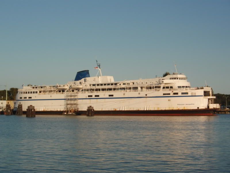 SiiTech says she's bow in but this photo says otherwise. Next Day the I-Sky Proved just as Easy 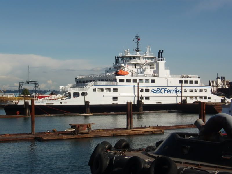 Word is from a crew member on the Tsawwassen last night she could be running as early as September 22nd. And the New West after a bit of parking confusion was easier. 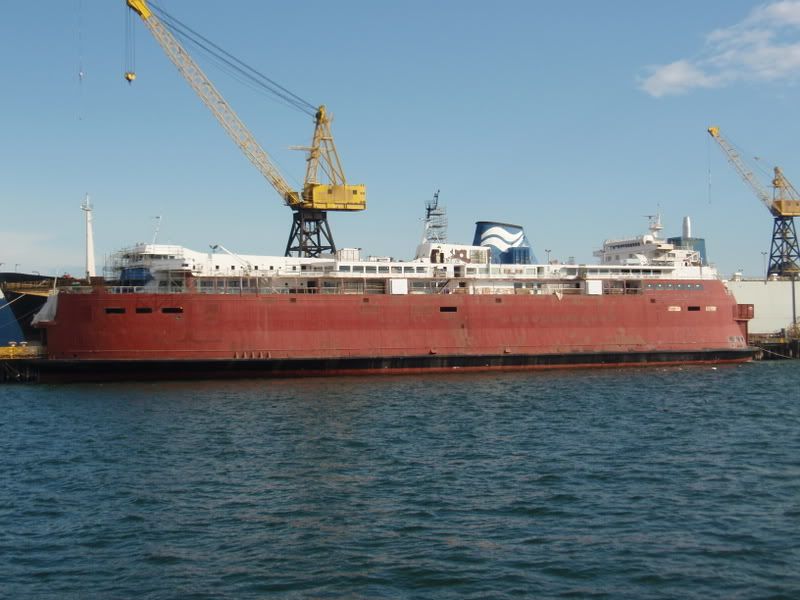 |
|
|
|
Post by Low Light Mike on Sept 1, 2008 19:09:13 GMT -8
In ShipRider-16's final pic, of the 'New Westminster, it looks as if she has acquired a new stern superstructure.
....but that bridge really belongs to a ship in the background......but the angle of the picture sure makes you look twice.
|
|
|
|
Post by Political Incorrectness on Sept 1, 2008 19:45:07 GMT -8
I am very sure flugel that the fixture is most likely a dumpster until otherwise proven, the mystery remains.
|
|
|
|
Post by Low Light Mike on Sept 1, 2008 19:59:51 GMT -8
I am very sure flugel that the fixture is most likely a dumpster until otherwise proven, the mystery remains. Look again. I'm talking about the bridge-superstructure of the ship behind & to the aft of the New Westminster. From the angle of ShipRider-16's picture, it appears that the other ship's bridge-superstructure is sitting on top of the New West's upper aft lounge. |
|
|
|
Post by Curtis on Sept 1, 2008 21:20:02 GMT -8
And just like magic, it disappears in this photo...  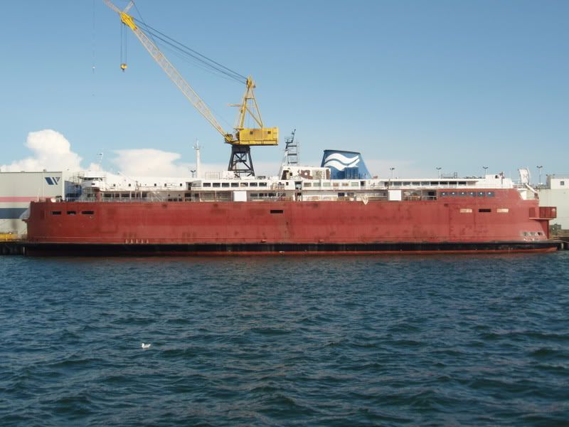 As an added bonus here's two Princesses in one photo...the Jacqueline and Superior. 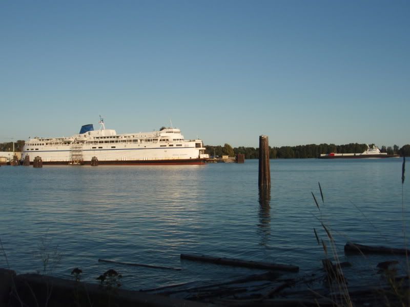 |
|