|
|
Post by Low Light Mike on Feb 15, 2009 21:15:38 GMT -8
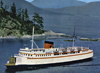
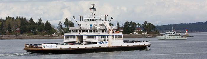
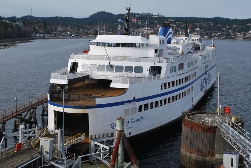
Nice pictures Flugal! Piper's lagoon is a great place for pictures. I once stood out there for an hour in the winter rain an wind to get some pictures but the weather looked pretty good today.  Thanks Canicks. I am still figuring out stuff on my new camera. Today's problem is the camera focusing on the nearest object (ie a rock island) instead of focusing on the ferry behind it. I just need to do some more reading of my Canon bible (hey, that's a bible pun ;D) and play with the settings to adjust where the focal point is. It was a nice sunny day to play around. |
|
|
|
Post by Canucks on Feb 15, 2009 21:47:53 GMT -8
Nice pictures Flugal! Piper's lagoon is a great place for pictures. I once stood out there for an hour in the winter rain an wind to get some pictures but the weather looked pretty good today. Thanks Canicks. I am still figuring out stuff on my new camera. Today's problem is the camera focusing on the nearest object (ie a rock island) instead of focusing on the ferry behind it. I just need to do some more reading of my Canon bible (hey, that's a bible pun ;D) and play with the settings to adjust where the focal point is. It was a nice sunny day to play around. Oh wow, I spelled your name wrong, and the sad part is that I quite often play the Flugel horn part in the band.  I hate that the camera focuses on the nearest object, but that is a fact of digital cameras. I don't really care where it focuses because a little sharpening in an editing program fixes it. Have fun with the canon bible, I got about to the install batteries section. ;D |
|
Koastal Karl
Voyager  Been on every BC Ferry now!!!!!
Posts: 7,747
|
Post by Koastal Karl on Feb 16, 2009 9:56:17 GMT -8
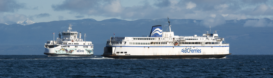
A few different photos from my trip to Vancouver this weekend. Coastal Rennie from atop the tower at the Harbour Center  Coastal Rennie passing Wytecliff Park on her 12:30pm sailing to Nanaimo  Queen of Coquitlam departing to Langdale  Queen of Capilano in Snug Cove  Queen of Capilano arriving at Snug Cove  Queen of Saanich at Deas  SOBC at Deas  Nor Ad at Deas  Queen of Tsawwassen was still at Deas but couldent get a photo of her. Queen of New West seen from Fred Gingell Park in Tsawwassen  SOVI arriving at Tsawwassen  |
|
|
|
Post by DENelson83 on Feb 16, 2009 10:47:53 GMT -8
Looks like the SOBC is getting a fresh coat of paint.
|
|
|
|
Post by Ferryman on Feb 16, 2009 20:09:50 GMT -8
|
|
|
|
Post by DENelson83 on Feb 16, 2009 22:06:45 GMT -8
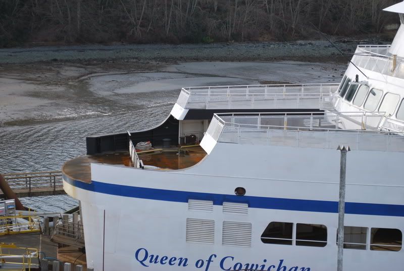
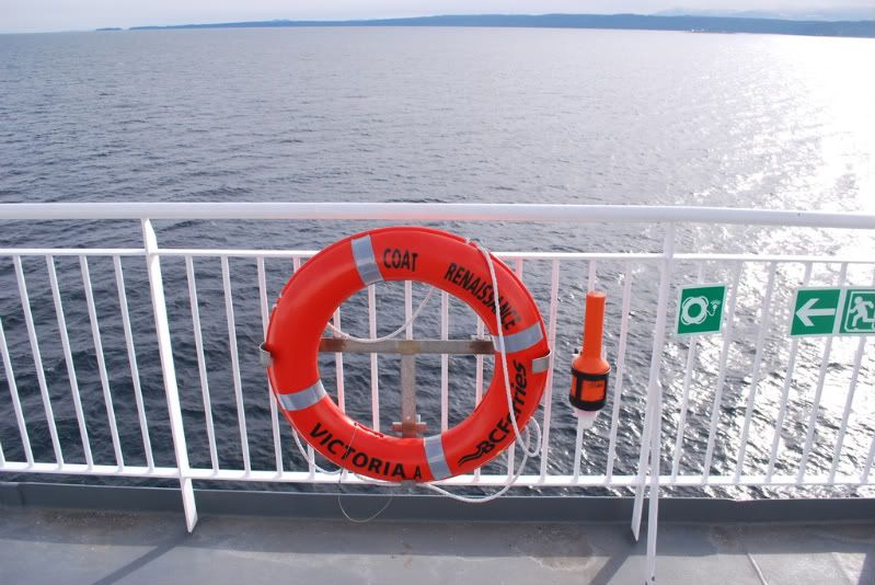 Oops... Better fix the words on that life ring.  And how come that EPIRB isn't attached to the ring? |
|
|
|
Post by Curtis on Feb 16, 2009 22:26:15 GMT -8
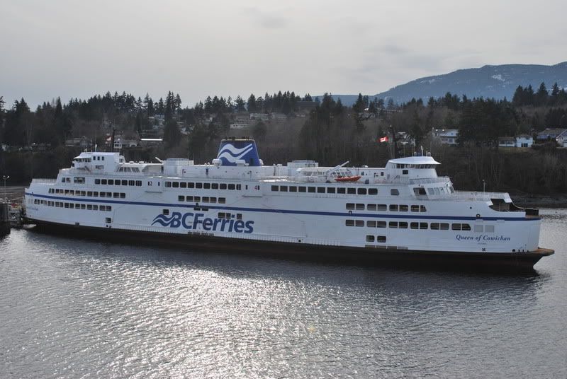
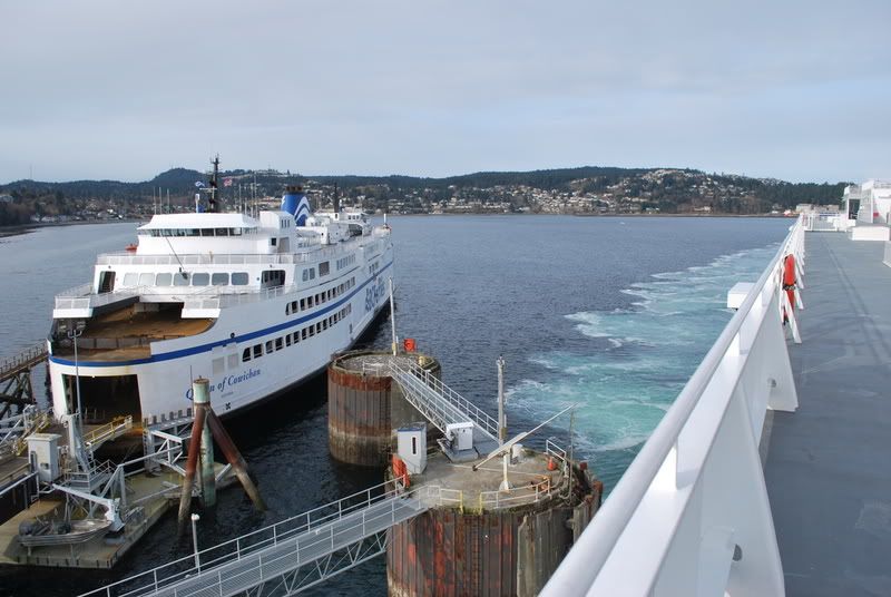
Nice shots to both Karl and Chris. Okay, who put the Life Ring from the Queen of Richmond's Renaissance Era Coat Hanger on the CR? To respect the builders, they made this life raft and put the city that it was built in, VICTORIAA. on it. I guess this is somebody's twisted joke...BC Ferries flopped again  ...and they Branded it too! Or since it was from the Richmond, was it one of us?    I doubt it was us, but if it is, you know the punishment... |
|
|
|
Post by Ferryman on Feb 16, 2009 22:34:23 GMT -8
I just looked at the full sized version, and the device is in fact tied to the life ring. The teather is just wrapped around the backside of the lifering. That's also not an EPIRB. An EPIRB otherwise known as Emergency Position Indicating Radio Beacon, is more commonly used when abandoning a vessel that the crew will activate in a liferaft. Another EPIRB is also set up on the Monkeys Island (Wheelhouse Roof) with a hydrostatic release, to float free when a sinking vessel reaches a certain depth. The EPIRB simply relays distress signals to Satellites, and the exact location of the device to make it easier for Search and Rescue to find you. Judging by the IMO image to the right, it simply tells me that the device beside the life buoy is a light. |
|
|
|
Post by DENelson83 on Feb 17, 2009 7:11:41 GMT -8
Weird... It looked like an EPIRB to me, which also makes sense because if you had a (wo)man overboard and tossed that life ring to him/her, if that device is an EPIRB, once it hits the water, it would activate and the bridge would instantly know there's a MOB.
Heck, it could also do double duty as a light. Next time I'm on a ferry, I'll take a second look and verify whatever the heck that is for myself.
|
|
|
|
Post by Ferryman on Feb 17, 2009 7:33:54 GMT -8
Hmm, an EPIRB would be overkill. If anything, I think a SART (Search and Rescue Transponder for those who don't know) would be better. That way the bridge could see it on the radar. But with the amount of incidents with people messing around with the life saving equipment on the outer decks, it would be quite pricey to have a bunch of SARTs in the publics eye waiting to be tampered with. I see where you're coming from though, and it might not be a bad idea.
|
|
|
|
Post by Northern Exploration on Feb 17, 2009 8:27:20 GMT -8
Chris is right the light is a strobe to help locating the individual at night. If someone knows enough to see that someone is overboard, letting the bridge know in short order isn't a problem. And to throw a lifering to someone you have to either be stopped near the individual or right there when they go overboard. But for the added expense and for the seconds it would save, not sure it would be worth it. The ship would be the primary rescue responder. Tthe automatic locators assume the ship is not able to be the locator (sinking or in trouble) and therefore some other responder has to be notified and helps the coast guard and others locate the scene/individual.
Having dozens of the automatic locators around is just a recipe for false alarms in my mind. Most of those I have seen are located far enough from the water and in protective larger housings, to prevent false alarms. The QoftN was on the upper deck and was away from any splash from a large wave for example.
|
|
|
|
Post by Low Light Mike on Feb 18, 2009 17:44:49 GMT -8
Fred Gingell Park: How do you get to it?
I have enjoyed the various photos that people take at Tsawwassen at Fred Gingell Park. Next time I do a Tsawwassen footie day-trip, I'm interested in walking down the causeway, and maybe accessing it.
What street is this park located at? I checked Google-maps and couldn't find it.
Hopefully it's only a couple of KM's from the base of the causway....
|
|
|
|
Post by Kahloke on Feb 18, 2009 19:24:24 GMT -8
|
|
Neil
Voyager
Posts: 7,291
|
Post by Neil on Feb 18, 2009 19:25:15 GMT -8
Fred Gingell Park: How do you get to it? I have enjoyed the various photos that people take at Tsawwassen at Fred Gingell Park. Next time I do a Tsawwassen footie day-trip, I'm interested in walking down the causeway, and maybe accessing it. What street is this park located at? I checked Google-maps and couldn't find it. Hopefully it's only a couple of KM's from the base of the causway.... Gingell Park, or more specifically, the beach at the bottom of it with it's illegal access to the U.S., is one of my favorite Delta places. It's not really accessible from a quick Tsawwassen ferry terminal stopover if you're on foot. You need to take a bus to the Ladner exchange, and another bus from there. Locate Point Roberts on Google Earth. Go up the west side; just over the border, find English Bluff Road running north. Between Second and Third Ave, you'll see a couple of cars parked in from the road- that's where the park is. There are some 'Panoramio' shots of the beach. |
|
|
|
Post by Low Light Mike on Feb 18, 2009 19:39:05 GMT -8
Thanks for the Gingell directions, gentlemen. Much appreciated.
|
|
|
|
Post by Northern Exploration on Feb 18, 2009 19:50:31 GMT -8
I have friends who live on Pacific Drive just further North along the bluff. We walked their dog along there - not sure how close we got to the border though. The view of the terminal above and below on the beach is quite impressive.
|
|
|
|
Post by Scott on Feb 18, 2009 22:17:18 GMT -8
Mike, you like walking, so maybe a 10k round-trip walk wouldn't bother you:) If so, you might be able to walk along the beach once you got to the end of the causeway (although 5k on the beach might be overkill:) Then there are stairs! The only possible problem is that the beach section does cross a First Nations reserve. Best time to go is at sunset though, so you'd probably prefer having vehicle access. If you're ever in town when the days are a bit longer let me know... I like having an excuse to go out there:) |
|
Koastal Karl
Voyager
Been on every BC Ferry now!!!!!
Posts: 7,747
|
Post by Koastal Karl on Feb 18, 2009 22:47:05 GMT -8
You can drive right to the border edge. What is to stop people from illegally crossing it?? There is nothing there to stop anyone. I have always wondered that and there is houses right there too.
|
|
Neil
Voyager
Posts: 7,291
|
Post by Neil on Feb 18, 2009 22:56:58 GMT -8
You can drive right to the border edge. What is to stop people from illegally crossing it?? There is nothing there to stop anyone. I have always wondered that and there is houses right there too. Karl, we walk across the border on the beach every time we go there. There used to be a sign marking the border, but it's been vandalized and pushed down. Recently, after crossing on the beach, I walked up a switchback trail and came out on the road- in the U.S. No houses right there, and little traffic to see you. Strange, in this era of Homeland Security. (Okay, just to be safe, I am NOT advocating that anyone do any illegal border crossing.) |
|
|
|
Post by Northern Exploration on Feb 19, 2009 8:12:32 GMT -8
Excuse me for a little sidebar that is off topic. Is the A frame style art gallery still in Point Roberts? Flugel would be interested in the homemade cinnamon buns they used to serve. I am not sure it is an appropriate venue for the ceremony since it isn't on the ferry but you can see ferries from the window . And now back to the regularly scheduled forum banter. |
|
|
|
Post by Low Light Mike on Feb 19, 2009 8:22:50 GMT -8
Mike, you like walking, so maybe a 10k round-trip walk wouldn't bother you:) If so, you might be able to walk along the beach once you got to the end of the causeway (although 5k on the beach might be overkill:) Then there are stairs! The only possible problem is that the beach section does cross a First Nations reserve. Best time to go is at sunset though, so you'd probably prefer having vehicle access. If you're ever in town when the days are a bit longer let me know... I like having an excuse to go out there:) I saw on Google-Earth that I should be able to walk on the beach and access the dead-end of a road, not too far from the beach condos by the causeway. Of course the "private, 1st nations land" might be an issue. But doing a walk around that area might be interesting and good exercise........in a few months. Thanks for all the advice again. |
|
|
|
Post by Low Light Mike on Feb 19, 2009 8:32:02 GMT -8
Excuse me for a little sidebar that is off topic. Is the A frame style art gallery still in Point Roberts? Flugel would be interested in the homemade cinnamon buns they used to serve. I am not sure it is an appropriate venue for the ceremony since it isn't on the ferry but you can see ferries from the window . The Coastal-Orthodoxy synod defrocked me (for aggressive grammatical inquisitions), thus preventing me from performing any future cinnamon-bun ceremonies. I risk future discipline from the synod if I proceed with more ceremonies. I'm thinking of starting a new coastal-orthodoxy denomination on my own, that gives me the freedom to eat cinnamon buns and also to check the punctuation of my flock. When you hear about someone nailing a thesis of cinnamon-buns to a wooden door, you'll know that I've made my decision. (and now back to the regular programming) ;D |
|
|
|
Post by Northern Exploration on Feb 19, 2009 8:42:01 GMT -8
Stares at ferry photos (topic of the thread ) trying to get the visuals of Flugel either in a frock or defrocked purged from my mind.  |
|
|
|
Post by Dane on Feb 20, 2009 0:11:40 GMT -8
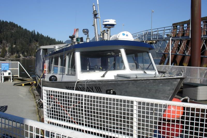 Stormaway III 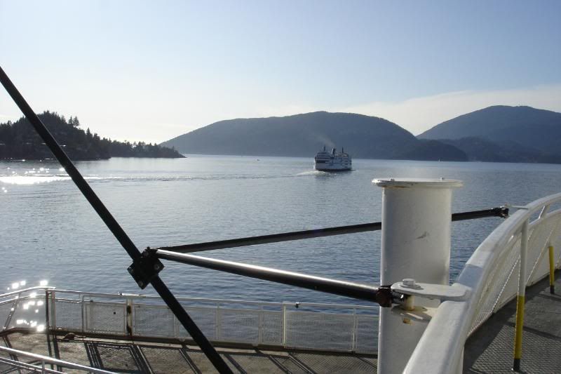 Queen of Oak Bay from the Queen of Coquitlam 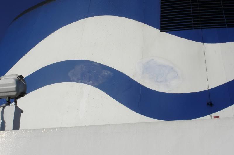 Some one tagged the Coquitlam's funnel! 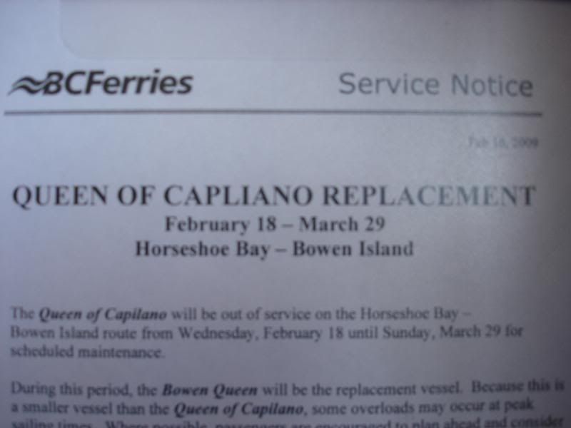 Spot the error! |
|
|
|
Post by ferryfanyvr on Feb 20, 2009 10:09:05 GMT -8
Queen of CapLIano replacement??!!
|
|


 ...and they Branded it too!