|
|
Post by Low Light Mike on Feb 9, 2008 16:49:47 GMT -8
Some northern news: ============== tinyurl.com/37lh9zFerries eyes three lots in Skidegate Landing BC Ferries is applying for a licence of occupation on three lots of crown land adjacent to its Skidegate Landing ferry terminal just in case it needs the extra space in the future, says spokesperson Deborah Marshall. The land became available because of a "foreclosure situation", Ms Marshall said. It wasn't land BC Ferries was counting on having. "It's a strategic maneuver," she explained. "You just don't know what your future needs are going to be." Ms Marshall said the ferry corporation is nearing the end of a strategic planning process for the Skidegate terminal which will outline what the facility will look like over the next 25 years. That plan should be complete by the end of March. Meanwhile, the approaching summer season will be the last for the Queen of Prince Rupert. The 42-year-old ship will be retired as soon as the brand new Northern Expedition arrives on the north coast next spring, Ms Marshall said. Starting with the summer 2009 season, BC Ferries plans to use the Northern Adventure to serve the Skidegate-Rupert route and the Northern Expedition on the Rupert-Port Hardy route. In the winter, the Northern Expedition will serve both routes, she said. There's no word yet on what will happen to the QPR after it's no longer needed by BC Ferries. The corporation recently offered some retired southern ferries for sale, and it's possible the QPR will be offered for sale also, Ms Marshall said. ============= |
|
|
|
Post by Low Light Mike on Feb 9, 2008 16:52:47 GMT -8
From the above story, it appears that the NorEx will be the #1 ship for the offseasons, and the NorAd will have a limited role.
Surprised?
|
|
|
|
Post by WettCoast on Feb 9, 2008 18:10:30 GMT -8
A few weeks ago I speculated about this on the Northern Adventure thread. No, I am not surprised.
|
|
|
|
Post by markkarj on Mar 30, 2008 9:02:36 GMT -8
Looks like the Alaska Marine Highway dock has to undergo some upgrading, but that BC Ferries dock will have to do the same (I presume for the arrival of the Northern Expedition). The one thought/question: does the Alaska Marine Highway do their border services screening before passengers board any Alaska-bound ships? If so, would they still hold any cars/passengers waiting to board in the Alaska holding queue, and then when ready to board, just drive through the BC Ferries area? I know it's a bit of a tight squeeze around there... there's the BC Ferries terminal, Via Rail also stops there, and then the Alaska dock. ------ JUNEAU EMPIRE, March 30 2008 Prince Rupert shuts down dock used by Alaska Marine Highway www.juneauempire.com/stories/033008/sta_263174277.shtml Problems with a dock used by the Alaska Marine Highway System in Prince Rupert, Canada, will force Alaska ferries to stop using the city-owned dock immediately, said Roger Wetherell, spokesman for the Alaska Department of Transportation and Public Facilities. An Alaska ferry scheduled to arrive in Prince Rupert on Saturday was canceled. Today, the Matanuska will attempt to moor at an alternate dock. "We've been authorized by BC Ferries to use their dock," he said. The government-run BC Ferries is the provincial ferry system for British Columbia. The Alaska ferry system needs to make sure its vessels fit the BC Ferries docks and the ramps work, Wetherell said. "We've looked at all the drawings and ship diagrams," he said. "It's a very tight fit." Wetherell estimated the chances were 50-50 that the alternate dock would work for the Alaska Marine Highway System. "We think it will work," said Herb Pond, mayor of Prince Rupert. He said the city has a good working relationship with BC Ferries, and it has been very helpful when they heard the city needed a place for Alaska ferries to dock. "They just said, right away, 'Whatever you need, we'll make it happen,'" Pond said. The moorage costs in Canada will remain the same and other expenses due to the change aren't expected to be significant, according to Alaska and Canadian officials. Wetherell said the city provided the ferry system with a report Thursday afternoon detailing problems with the dock's structural integrity. Alaska Marine Highway managers quickly decided they could not use the dock until it was refurbished, and made the decision to look for an alternative location. Pond said Prince Rupert hopes to have $1 million in repairs done by Memorial Day, when ferry traffic picks up on both systems. Travelers scheduled to pass through Prince Rupert on Alaska ferries are being notified of the changes, when it's possible, Wetherell said. "We're trying to contact everyone we can now," Wetherell said. BC Ferries terminal is adjacent to the Alaska Marine Highway facility, and will be convenient for travelers, Pond said. Both U.S. and Canadian customs are having to make some accommodations, he said. "There are some technical issues," Pond said, but both agencies are willing to work with the city. The city of Prince Rupert will handle installation of additional signs and fencing needed, he said. Alaska may get to return the favor from BC Ferries in the fall. The provincial ferry system plans an upgrade to its dock and will be using the Alaska dock during that work, Pond said. |
|
|
|
Post by WettCoast on Mar 30, 2008 10:29:20 GMT -8
The dock used by the AMHS vessels was built by the Canadian federal govt in the early 1960's. Originally it was used by AMHS vessels only. In 1966, however, it also became the Rupert dock used by BC Ferries, when the QPR started its Inside Passage service. Not until ~1980 did BC Ferries construct its own adjacent dock. Passengers must clear US customs in Prince Rupert before boarding AMHS vessels. Likewise, those disembarking from AMHS must immediately clear Canadian customs. There is (was) an intricate fencing system at the Alaska terminal which was used to fence off the vehicle holding compound into 'US' or 'Canadian' territory depending on which vessel was in the dock. The fencing was still there as of two weeks ago, but has not (to my knowledge) been used in 25+ years so likely does not work the way it once did. The Alaska berth is now owned by the city of Prince Rupert, I gather. Somewhere along the line the government of Canada must have pawned it off on them. BC Ferry vessels always had second priority at that dock meaning that they had to clear the dock when AMHS vessels came calling. That had a negative impact on maintaining schedules for BCF, especially once the service to QCI was started and potentially three vessels were about looking for space at just one dock. This is what prompted BCF to construct their own berth. The Alaska berth is a 'old style' wooden one, of the type that are fast disappearing along our coast. I gather it has had only minimal maintenance during recent years. Very likely it could use a complete rebuild.  QPR at the Alaska berth - August 1975 QPR at the Alaska berth - August 1975 - photo © JSTIt would make sense today for BCF, the AMHS, and the city of Prince Rupert to work more closely to share the available berths. Among other things, the Alaska berth would be better suited for use by the NorAd, as it is is not blessed with a long curved jetty along which big rigs must be carefully backed, as is the case with BCF's own berth. |
|
|
|
Post by Coastal Canuck on Feb 19, 2008 15:57:53 GMT -8
I know for sure that there is only 1 berth at Port Hardy but that is the only Northern Terminal I have been to
|
|
|
|
Post by Northern Exploration on Feb 19, 2008 16:17:37 GMT -8
None of the Northern Terminals have two docks. The ferries have to loiter when they arrive at a terminal and another ferry is late. There was a video of the NorAd and QPR meeting that way in Rupert on one of the threads.
|
|
|
|
Post by Low Light Mike on Feb 19, 2008 19:08:54 GMT -8
At Port Hardy:
There was (and maybe still is) a fuel-dock at Bear Cove, where the extra ship can tie-up for the night on those rare occasions.
But usually the Chilliwack arrives early morning, after the 7:30am summer inside-passage trip has already departed. Or other times the Chilliwack arrives/departs in early evening, again before the inside-passage ship arrives at 10:30pm.
|
|
|
|
Post by WettCoast on Nov 8, 2006 21:34:16 GMT -8
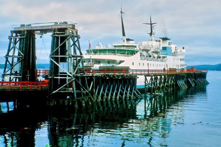
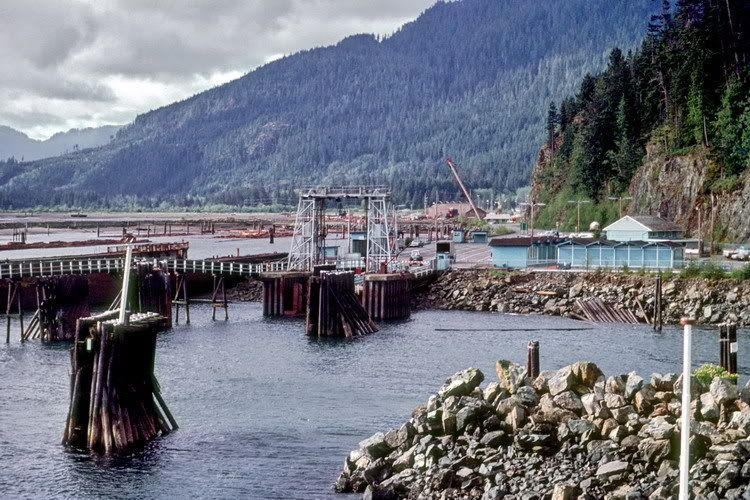
 For the time being I will leave this without explanation except to say that it is from 1978 of a BCF terminal. I will let forum members figure it out. |
|
|
|
Post by Curtis on Nov 8, 2006 21:56:07 GMT -8
Something tells me thats Kelsey Bay. Cause I've never seen that terminal before.
|
|
|
|
Post by WettCoast on Nov 8, 2006 22:55:01 GMT -8
Smart people on this forum, I have to say. The location is Kelsey Bay. It was the southern end for BCF's Inside passage route from 1966 to 1979. The southern terminal was moved to Bear Cove (Port Hardy) in 1979 once the Island Highway was completed between Sayward and Beaver Cove. KB was also the southern terminus of the NIP's run to Beaver Cove.
Does anyone know if any of the terminal facilities at KB are still there today?
|
|
|
|
Post by Low Light Mike on Nov 9, 2006 6:18:06 GMT -8
I drove into Kelsey Bay in 1998, and I didn't see any terminal structures (ie. ramps, counterweight-towers, etc).
But then, I probably didn't really know what I was looking for. I think it just looked like a Gov't wharf.
Same thing on the Q-North positioning cruise in Oct.2005: we passed Kelsey Bay, and I didn't see anything terminal-like there, from the water.
|
|
Koastal Karl
Voyager   Been on every BC Ferry now!!!!!
Posts: 7,747
|
Post by Koastal Karl on Aug 14, 2008 21:38:49 GMT -8
I was looking at the Inside Passage schedule and in October it looks like Port Hardy will be closed for berth maintenance so the Queen of Prince Rupert will be using Port McNeil according to the schedule it even lists Port McNeil on the schedule which I thought was interesting. Maybe it would be a good time to plan a trip on the Rupert then. It's either late night arrivals into Port McNeil or early morning departures. It would be neat to see her there.
From the schedule
* Note: Due to berth closures at Port Hardy departures will be from Port McNeill
|
|
|
|
Post by DENelson83 on Aug 14, 2008 21:43:46 GMT -8
Port McNeill??? Is that berth even big enough?
|
|
|
|
Post by WettCoast on Aug 18, 2008 7:29:21 GMT -8
I checked the north coast winter schedule out a couple of weeks ago and saw that they were planning to do this in the spring. I assumed that this was needed to prepare the Bear Cove berth for the soon to arrive NorEx. The fall closure? why? Maybe to repair damage done by the NorAd while backing into this terminal?
|
|
|
|
Post by fargowolf on Oct 20, 2008 19:00:18 GMT -8
I drove into Kelsey Bay in 1998, and I didn't see any terminal structures (ie. ramps, counterweight-towers, etc). |
|
|
|
Post by Northern Exploration on Oct 20, 2008 19:25:07 GMT -8
Somewhere south of Port McNeill I remember a ferry dock. I clearly remember driving a long way down a fairly rough road to a parking area and a ferry ramp. I can't remember for the life of me where exactly it was. It was somewhere between a half hour to an hour drive from Telegraph Cove. You went in from the Island Highway. We parked and got out - people were launching boats. A cruise ship went by as we were there. There were no ferry buildings there. This would have been around the time or later than you were there Flug. Does anyone know what I was seeing?
|
|
Ferryman
Voyager  
Posts: 7,483
Member is Online
|
Post by Ferryman on Oct 20, 2008 19:55:38 GMT -8
Perhaps this might have been the dock, the North Island Princess would use? I'm not sure exactly which ports she went to...but I do know she spent some time going up to Kelsey Bay from Port McNeil or something...
|
|
|
|
Post by WettCoast on Oct 20, 2008 21:48:12 GMT -8
Perhaps this might have been the dock, the North Island Princess would use? I'm not sure exactly which ports she went to...but I do know she spent some time going up to Kelsey Bay from Port McNeil or something... The NIP route was Kelsey Bay to Beaver Cove. Once the Island highway was extended (~1979) via the inland route from Sayward to Beaver Cove this service was discontinued, and the Inside Passage route southern terminal was moved to Bear Cove. The ferry slip that 'Northern Exploration' saw was likely the old facilities at Beaver Cove. |
|
Mill Bay
Voyager   Long Suffering Bosun
Posts: 2,887 
|
Post by Mill Bay on Oct 20, 2008 22:00:19 GMT -8
I drove into Kelsey Bay in 1998, and I didn't see any terminal structures (ie. ramps, counterweight-towers, etc). I remember being at Kelsey Bay in what was probably the early 90s and the ferry terminal was clearly identifiable with the vacant holding lot and lanes markings still clearly visiable on the pavement. I can't remember if the elevator structure was still there or not, but you could tell where the ferry ramp would have been as it was a very straight edged ledge at the end of the holding lot. I also can't remember if any of the dolphins or wing walls were still there, but it's possible they might have been. |
|
|
|
Post by Northern Exploration on Oct 21, 2008 7:06:23 GMT -8
Thanks WCK that fits with the general timing of where we went as we drove to Port Hardy. We left Duncan after breakfast and wanted to get to Port Hardy for early evening/dinner so took a lot of side trips up the Island highway. So if we saw anything that looked interesting we checked it out.
|
|
Neil
Voyager  
Posts: 7,307
|
Post by Neil on Oct 21, 2008 9:12:34 GMT -8
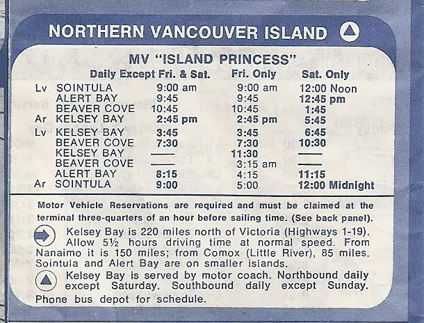
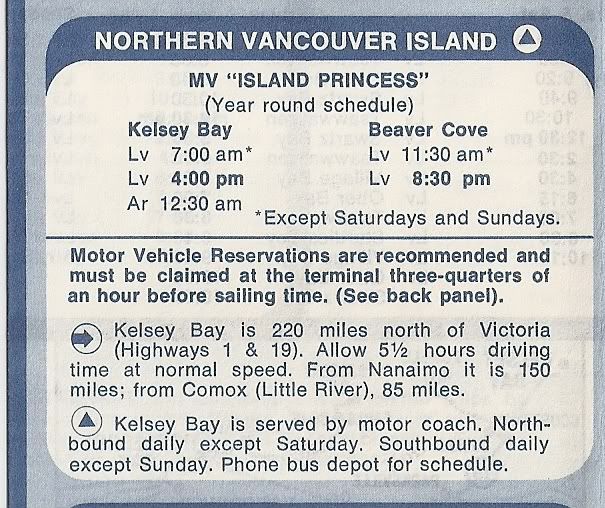
Perhaps this might have been the dock, the North Island Princess would use? I'm not sure exactly which ports she went to...but I do know she spent some time going up to Kelsey Bay from Port McNeil or something... The NIP route was Kelsey Bay to Beaver Cove. Once the Island highway was extended (~1979) via the inland route from Sayward to Beaver Cove this service was discontinued, and the Inside Passage route southern terminal was moved to Bear Cove. The ferry slip that 'Northern Exploration' saw was likely the old facilities at Beaver Cove. Up until sometime between the summer of '72 and the summer of '73 the Island Princess went from Kelsey Bay to Beaver Cove, Alert Bay, and Sointula. At that time, the route was split, with (I believe) the Nimpkish taking over the Alert Bay and Sointula portion. Don't know when the Beaver Cove terminal was switched to Port MacNeill. summer '72:  summer '73 summer '73:  |
|
|
|
Post by Starsteward on Nov 12, 2008 8:37:35 GMT -8
On a trip last year on the Nor Ad, I stopped by Kelsey Bay and there are some reminants of the old terminal but the most obvious remains are the old ship breakwaters on the south side of what would have been the dolphins/dock.
|
|
|
|
Post by Low Light Mike on Sept 10, 2009 10:15:20 GMT -8
The bay at the site of Fort McLoughlin:  Shearwater:  |
|
Koastal Karl
Voyager   Been on every BC Ferry now!!!!!
Posts: 7,747
|
Post by Koastal Karl on Sept 30, 2009 9:51:34 GMT -8
Does anyone know if there is a toll booth at Bella Bella Shearwater, and Ocean Falls??? I know there isent one at Klemtu as I have been there but there are fares for Shearwater to Bella Bella but now that I think of it when you book you pay in advance so I doubt now there would any toll booths up there. But then how would you check in like at Shearwater Klemtu and Ocean Falls??? Do you have to reserve from Shearwater to Bella Bella?? I think you would being it's a northern route but then again you dont have to from Skidegate to Alliford Bay. I know Bella Coola has a check in area. Just curious on the other terminals.
|
|