|
|
Post by Nickfro on Dec 1, 2009 17:15:57 GMT -8
I'm glad this thread title refers to 'dream' routes, because this one has very little basis in reality. As Viking mentioned, it's well over twice the distance of route 2, so we're looking at a crossing of three and a half hours. For most of its length, it would parallel the island highway, with the difference being that you could drive the same distance three or four times as fast. With what BC Ferries would have to charge to make any money on it, even my eight cylinder pig car could get me to Courtenay considerably cheaper. Since it parallels a highway, there would be no federal subsidy, and the province certainly wouldn't kick in for such an unnecessary route, so BC Ferries would be left to promote it as a purely tourist venture. Given the fact it would be sailing up the middle of the strait, that would have very limited potential. So... dream on. I think this route would actually be quite popular, because only to people living Southern Van Isle does it run parallel to a highway. If you're a Vancouverite or from anywhere else on the coast, It would be quite popular (imho) for anyone travelling the the Comox Valley, Campbell river, or anywhere further north like Port Hardy, the Northern G. Islands, or Prince Rupert (via northern ferry). During the winter this route would be especially popular. Nobody wants to drive hwy 19 when it's snowing. If there's even a centimetre of snow on the road, travel time almost doubles, increasing the Horseshoe bay-departure bay- courtney via hwy 19 almost 4 hours. The rates wouldn't be much different on this "new" route, and it would be a MUCH safer alternative to the Island Hwy. Maybe it could run as a winter only route, since that's when Horseshoe bay is least crowded (and when it would be faster and safer), then during the summer, whichever ship runs that route could run route 1. Good grief. How on earth do you think that the rates wouldn't be much different for a run that would be at least twice the length than Route 2, especially considering that the 'Island Speedway' exists? Secondly, how on earth would there be more demand during the winter months compared to the summer months? Quite often when it's snowing, it's windy, which would make this run cancelled quite often during those times. Oh yeah. . .it snows on average about 10 times a year at sea level. . .too seldom to consider this option in that context. |
|
|
|
Post by lmtengs on Dec 1, 2009 17:21:27 GMT -8
My dream route: It would be from Kelsy Bay to Kitimat This would be a great second route up the Inside Passage and would provide a unique round trip for tourists. Port Hardy to Prince Rupert one way, Kitimat to Kelsey Bay the other. It also has the advantage of providing alternate terminals if, for whatever reason, ferries couldn't use Port Hardy or Prince Rupert. Geographically a good conept, but realistically, watch for the good souls in 'Rupert to scream in pain over that one. Both Prince Rupert and Port Hardy are largely protected from severe sea conditions. It's reminscent of when a proposal (resurrected) before the BC Liberals became gummint, was made to branch off the Coquihalla at Comstock Rd, to climb the hills eastward to Aspen Grove where such an extension would meet the Okanagan Connector to Peachland. When Merritt found out about it, they screamed and a few wanted to brand the NDP MLA there the way the local ranchers brand the cattle. It made sense for trucks, since they wouldn't have to go through the descent to Merritt only having to climb up again a short time later for the haul to the interchange at Aspen Grove. Not much distance between Kitimat and 'Rupert to justify such a means, but granted a ferry terminal in Kitimat would bring few positive things to a town that certainly needs it after going through alot of bad stuff. Rupert's pretty down and out to though these days. Their population has been decreasing each year for a long time now. Just check out these not-so-pretty photos:  The old train station, where my mom worked as a teenager    Kind Edward Elementary  Okay, here's an interactive activity. 1)Put your hand over about 1/5 of the houses. 2) All the homes covered by your hand are abandoned or have been for sale for a VERY long time.  at least they still have countless trains coming into the superport everyday  |
|
|
|
Post by DENelson83 on Dec 1, 2009 18:36:39 GMT -8
It is one of a few areas of practice, the other being Whiskey India offshore from Kye Bay in Comox. I've never known WI to be active, just WG. BTW, you'll notice that I've plotted where WG is on WikiMapia. If any of the other military practice areas near the coast were in use, I'd plot them there as well. |
|
Mill Bay
Voyager  Long Suffering Bosun
Posts: 2,886 
|
Post by Mill Bay on Jan 24, 2010 16:40:35 GMT -8
Anyway... so, is now a bad time to tell you about my latest ferry dream? Guess I will anyway.
Seems myself and several forum members took a trip on what was listed as Route 5A, but it doesn't seem to have been anything like the route five we're familiar with. It started out from Tsawwassen at sunset, but it was aboard one of the smallies, either Nicola or Nimpkish. One bit of good luck we had was seeing the Queen of Sidney operating near the mouth of the river, under her own power, waiting a tide change, so it's good to know she's still looking lively and busy.
The route crossed the straight and ended up in some mysterious cove somewhere, where there wasn't even an existing ferry berth, just a wood pier, meaning that only foot passengers could leave. However, this was also the layover point, requiring those of us travelling on to the next port of call to overnight aboard the ship, which is not easy on a ship the size of the Nimpkish. We camped out in one of the saddle lounges, but it was a pretty rough night. Never did find out what the route's final port of call was, though.
|
|
D'Elete BC in NJ
Voyager
Dispensing gallons of useless information daily...
Posts: 1,671
|
Post by D'Elete BC in NJ on Jan 25, 2010 4:13:07 GMT -8
Anyway... so, is now a bad time to tell you about my latest ferry dream? Guess I will anyway. Seems myself and several forum members took a trip on what was listed as Route 5A, but it doesn't seem to have been anything like the route five we're familiar with. It started out from Tsawwassen at sunset, but it was aboard one of the smallies, either Nicola or Nimpkish. One bit of good luck we had was seeing the Queen of Sidney operating near the mouth of the river, under her own power, waiting a tide change, so it's good to know she's still looking lively and busy. The route crossed the straight and ended up in some mysterious cove somewhere, where there wasn't even an existing ferry berth, just a wood pier, meaning that only foot passengers could leave. However, this was also the layover point, requiring those of us travelling on to the next port of call to overnight aboard the ship, which is not easy on a ship the size of the Nimpkish. We camped out in one of the saddle lounges, but it was a pretty rough night. Never did find out what the route's final port of call was, though. lol...that takes me back to when I was 7 or 8 and the Blubber Bay terminal was being rebuilt. Those little boats would sidle up beside the dock (opposite to the side you can see here www.sunshinecoast-bc.com/images/vanandadock1.jpg), and we would clamber aboard for the weekly excursion to Powell River to play soccer. ;D |
|
|
|
Post by Scott on Feb 1, 2010 23:53:26 GMT -8
What about passenger ferries on the Fraser River? I think the Fraser River is an underused "highway" right through the middle of the Lower Mainland. You've got all sorts of destinations along the river:
Attractions/Parks: Steveston, Fort Langley, Westminster Quay, Deas Regional Park, Fraser Foreshore Park, Richmond Skating Oval
Town Centers: New Westminster, Richmond, Maple Ridge, Ladner
Transportation Hubs: New Westminster Skytrain, Richmond RAV Line, Maple Ridge West Coast Express Station, Vancouver International Airport
Industrial Centers: North Arm of the Fraser and Mitchell Island, Mary Hill Industrial Park (Pitt River), Port Kells, Tilbury/River Road, port operations in Surrey/Delta, Annacis Island
Shopping: New Westminster, Queensborough Landing, Richmond, United Boulevard
High Density Residential: South-east Vancouver, Queensborough, New Westminster, Steveston
If the boats could handle the ocean, it wouldn't be a long stretch to Delta Port, Tsawwassen ferry terminal, or the University of British Columbia.
I think it would be hard for a private company to make a go of it. However, if it had public funding and was integrated with the Translink network, I think a lot of people would use it.
|
|
|
|
Post by lmtengs on Feb 2, 2010 20:40:38 GMT -8
I've actually been thinking of something around those same lines lately, and now I've decided to make a map of it. maps.google.com/maps/ms?ie=UTF&msa=0&msid=110313778382438398287.00047ea9ab196bbdd4bc2 You and others can edit the map to your liking, so you can add routes and add stops to current routes. |
|
|
|
Post by paul on Feb 20, 2010 13:56:23 GMT -8
hello! i am new to this board and trying to find out if there is a ferry that runs from prince ruppert to bella coola. any help appreciated.
|
|
|
|
Post by WettCoast on Feb 21, 2010 20:52:03 GMT -8
hello! i am new to this board and trying to find out if there is a ferry that runs from prince ruppert to bella coola. any help appreciated. Yes, you can, both summer and during most of the rest of the year. For details please go here. See reply #5. |
|
|
|
Post by DENelson83 on Mar 7, 2010 0:21:15 GMT -8
Here's a ferry route I'd love to see—between Mary Point on Cortes Island and Sarah Point on the Malaspina Peninsula. That would allow Cortes Island to be supplied from Powell River instead of Campbell River.
|
|
|
|
Post by lmtengs on Mar 7, 2010 20:43:11 GMT -8
How about Ucluelet to Port Renfrew? Two smaller ferries, a bit like Tenaka would do great for that route.
|
|
|
|
Post by lmtengs on Mar 7, 2010 22:24:47 GMT -8
I thought she was made to withstand rougher seas.... okay, then. What kind of ship would suit that route?
Maybe a ship, still looking like the tenaka, but with a deep hull and lower center-of-balance with vehicle deck doors and modified lounges with extra-thick windows so they don't break from the waves. Lifeboats would need to be strapped down tighter too...
|
|
|
|
Post by Kahloke on Mar 7, 2010 22:39:51 GMT -8
Here's a ferry route I'd love to see—between Mary Point on Cortes Island and Sarah Point on the Malaspina Peninsula. That would allow Cortes Island to be supplied from Powell River instead of Campbell River. I like that idea. How far up Malaspina Peninsula does the road, or roads, go? What would be really cool is if they added that crossing and kept the existing Whaletown-Heriot Bay run. That's one loop trip I would certainly make it a point to do. |
|
D'Elete BC in NJ
Voyager
Dispensing gallons of useless information daily...
Posts: 1,671
|
Post by D'Elete BC in NJ on Mar 8, 2010 4:20:36 GMT -8
Here's a ferry route I'd love to see—between Mary Point on Cortes Island and Sarah Point on the Malaspina Peninsula. That would allow Cortes Island to be supplied from Powell River instead of Campbell River. I like that idea. How far up Malaspina Peninsula does the road, or roads, go? What would be really cool is if they added that crossing and kept the existing Whaletown-Heriot Bay run. That's one loop trip I would certainly make it a point to do. Lund is basically the end of the road for the 101 and the really decent thoroughfare. You can get out to Sarah Point, but I'd think it would be much more cost effective to spend a little more time on the water instead of upgrading the infrastructure north of Lund. Looking at the satellite images, I'm trying to figure out where you could put a terminal that would be protected from the south east wind. The waves generated from such winds tend to have a longer time to form and thus cause docking issues for this area of the strait. I think somewhere near the end of Finn Bay Road would suffice, though it might be better to get closer to town...say Sorenson Rd area. |
|
D'Elete BC in NJ
Voyager
Dispensing gallons of useless information daily...
Posts: 1,671
|
Post by D'Elete BC in NJ on Mar 8, 2010 9:58:17 GMT -8
Lund is basically the end of the road for the 101 and the really decent thoroughfare. You can get out to Sarah Point, but I'd think it would be much more cost effective to spend a little more time on the water instead of upgrading the infrastructure north of Lund. Looking at the satellite images, I'm trying to figure out where you could put a terminal that would be protected from the south east wind. The waves generated from such winds tend to have a longer time to form and thus cause docking issues for this area of the strait. I think somewhere near the end of Finn Bay Road would suffice, though it might be better to get closer to town...say Sorenson Rd area. Lund is in a bay, so it would be more practical - if such a route was even ever thought of. The route should take in a stop of Savary Island (passengers only), then sail to Cortes. But such a route wouldn't be fiscally benificial unless it was part of a larger service route serving the islands 9and even then most of the stops would be passenger only). There's very little traffic north of Powell River. Yes, abeit a small one, and quite busy, full of marinas for those people lucky enough to be wandering Desolation Sound and the northern gulf islands. A quick look at Google will confirm and explain my two choices. On another note, the reason there is little traffic north of Powell River is mostly because you can't really get anywhere from there and unless you cut trees, or net fish for a living, there's not exactly much industry to draw destination specific crowds. |
|
Mill Bay
Voyager
Long Suffering Bosun
Posts: 2,886
|
Post by Mill Bay on Mar 8, 2010 10:05:06 GMT -8
I thought she was made to withstand rougher seas.... okay, then. What kind of ship would suit that route? Maybe a ship, still looking like the tenaka, but with a deep hull and lower center-of-balance with vehicle deck doors and modified lounges with extra-thick windows so they don't break from the waves. Lifeboats would need to be strapped down tighter too... Maybe the QPR...? |
|
|
|
Post by lmtengs on Mar 8, 2010 15:37:04 GMT -8
I thought she was made to withstand rougher seas.... okay, then. What kind of ship would suit that route? Maybe a ship, still looking like the tenaka, but with a deep hull and lower center-of-balance with vehicle deck doors and modified lounges with extra-thick windows so they don't break from the waves. Lifeboats would need to be strapped down tighter too... Maybe the QPR...? Right kind of idea, but too big and old of a ship. There wouldn't be that much traffic to that area, just tourists and logging trucks pretty much. I don't think there are any perfect examples currently sailing the Coast of the Americas. |
|
Neil
Voyager
Posts: 7,187
|
Post by Neil on Mar 8, 2010 17:06:52 GMT -8
Here's a ferry route I'd love to see—between Mary Point on Cortes Island and Sarah Point on the Malaspina Peninsula. That would allow Cortes Island to be supplied from Powell River instead of Campbell River. I think Cortes Islanders would prefer to keep their existing connection. The Courtenay area has a lot more services than Powell River, and it also has a lot of medical specialists, as well as the regional St. Joseph's Hospital. There is also the hospital in Campbell River. Many Powell Riverites use the Comox ferry to get to medical appointments on the island. Goods and services can come over just as easily from Vancouver Island as from the mainland. Powell River has grown, and would be slightly more convenient for regular shopping, but there are more important reasons for Cortes to still be connected to the Island via Quadra. A population of only a thousand means that ferries to both the mainland and Quadra would be out of the question. |
|
|
|
Post by Curtis on Mar 8, 2010 17:25:44 GMT -8
Lund is in a bay, so it would be more practical - if such a route was even ever thought of. The route should take in a stop of Savary Island (passengers only), then sail to Cortes. But such a route wouldn't be fiscally benificial unless it was part of a larger service route serving the islands 9and even then most of the stops would be passenger only). There's very little traffic north of Powell River. Yes, abeit a small one, and quite busy, full of marinas for those people lucky enough to be wandering Desolation Sound and the northern gulf islands. A quick look at Google will confirm and explain my two choices. On another note, the reason there is little traffic north of Powell River is mostly because you can't really get anywhere from there and unless you cut trees, or net fish for a living, there's not exactly much industry to draw destination specific crowds. Something like this has been on my mind for awhile, I've debated to myself how it would possibly work. I see a 30-40 car vessel (between a K Class and a Q Class) operating the route with the ability to make a stop at Savary a few times a day (so it does not run the Lund Water Taxi out of business) and like Mr. Keenleyside said, it would just drop off passengers. For a potential terminal in Lund, I drew this up as an idea, 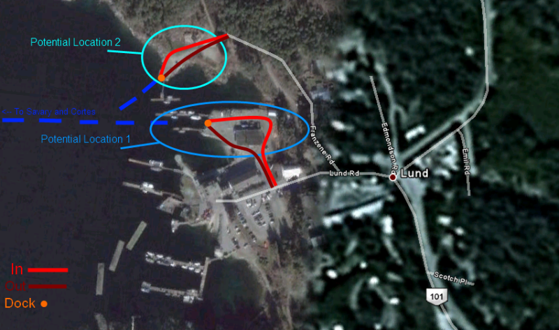 Due to the size of Lund, the terminal would consist of a ticket booth and a road line-up, possibly with two lanes for extra space. They'd have to pull a few strings with the people in charge of the present boat docks to pull it off though. Also, this Ferry route would NOT be an extension of Highway 101. |
|
|
|
Post by lmtengs on Mar 8, 2010 18:58:59 GMT -8
Something like this has been on my mind for awhile, I've debated to myself how it would possibly work. I see a 30-40 car vessel (between a K Class and a Q Class) operating the route with the ability to make a stop at Savary a few times a day (so it does not run the Lund Water Taxi out of business) and like Mr. Keenleyside said, it would just drop off passengers. For a potential terminal in Lund, I drew this up as an idea, Due to the size of Lund, the terminal would consist of a ticket booth and a road line-up, possibly with two lanes for extra space. They'd have to pull a few strings with the people in charge of the present boat docks to pull it off though. Also, this Ferry route would NOT be an extension of Highway 101. I like your drawings a lot (I think I'll make one for my potential route that I suggested above), but I think it would be easier if the boat launch is used as the ferry berth, and the ship could have ramps installed, similar to those on Kwuna. The wavebreakers would need to be moved to make this a possible access point, though. |
|
|
|
Post by WettCoast on Mar 8, 2010 20:59:17 GMT -8
A ferry between Cortes Island and the Sunshine Coast at or near Lund would have some appeal. It is not that far across, and would certainly open up some nice opportunities for circle tours and ferry enthusiasts tours. As for economic sense, maybe not. As for a ferry serving the west coast of Vancouver Island - its not going to happen! Reasons have already been provided above. There once was a passenger service along the Island's west coast, however. It was operated for about 40 years by the CPR's BC Coast Service. The vessel that serviced that route throughout almost all of that period was the Princess Maquinna.
One ferry route on the west side of the Island that might make some sense would be a crossing of the inland end of Barkley Sound or the lower end of the Alberni Canal. Though such a route would take traffic away from the Frances Barkley, it would provide much improved connections (especially for vehicles) between areas on the north and south sides of Barkley Sound/ Alberni Canal. This waterway, in case you haven't noticed, cuts Vancouver Island almost in half. This would be a place where one of the former Albion ferries could be put to good use. |
|
|
|
Post by Nickfro on Mar 9, 2010 10:53:03 GMT -8
I too like the notion of this route, from a ferry enthusiast's perspective. Economically and realistically. . .not so much. It sure would be a neat way to circle around and see a lot more of the areas that BC Ferries offers us. Taking some ideas from another thread, perhaps this new route could use the NIP and Texada gets something like a 64 car fully enclosed ferry. I like your drawings a lot (I think I'll make one for my potential route that I suggested above), but I think it would be easier if the boat launch is used as the ferry berth, and the ship could have ramps installed, similar to those on Kwuna. The wavebreakers would need to be moved to make this a possible access point, though. Using the launch sure would be a nice, cheap way to set up a new ferry berth. However, the waters are not protected enough for the Barge Class to be an adequate type of ferry for this route. Furthermore, they would then have to build another boat launch anyways, as the launch is important to the people of Savary and Hernando Islands at the start and end of their cabin seasons. The existing launch isn't in a good spot for a ferry either, and the existing marina can't be compromised. The marina is Lund. I think one of the two spots that Curtis identified could work, myself preferring the north one to move it away from the marina as much as possible. |
|
Neil
Voyager
Posts: 7,187
|
Post by Neil on Mar 9, 2010 11:54:20 GMT -8
Well, okay, let's assume David Hahn's ferry godmother threw him a whole wack of cash, and said, "Now, David, don't spend this on bonuses, do something new and nice for folks on the coast".
A few ideas, some goofier than others, some of which I might have mentioned before.
- Marktosis, on Flores Island north of Tofino, is one of the largest communities on the coast that has no car ferry service. A small sea going vessel would be needed for a 75- 90 minute run.
- Once a week in summer, the route 11 vessel does a direct run between Skidegate and Port Hardy.
-Summer only, a small to intermediate sized vessel on a run between Departure Bay and Langdale, reservations only.
- Summer only, the Tenaka, with it's coffee shop re-installed, doing three round trips a week between Campbell River, the Discovery Islands, Broughton archipelago, and Port MacNeill.
- Passenger ferry service from downtown Vancouver to Gibsons and Nanaimo. Let's quit farting around with small private operators and do something sustainable.
- New route 12 terminals on either side of the entrance to Saanich Inlet, with a larger ferry, making better connections between Swartz Bay and the Cowichan area.
- On Salt Spring, a new terminal in the Eleanor Point area, replacing Fulford & Long Harbour, and cutting route 4 sailing time.
BC Ferries isn't the only operator that could offer new services. Translink could run boats along the Fraser that would serve commuters, tourists, and cyclists. Starting as far east as Fort Langley, stopping at Maple Ridge, Derby Reach Park, Port Hammond/Pitt Meadows, somewhere in Surrey, and New Westminster, before branching off to travel the north arm to Queensborough, Burnaby Foreshore Park, the Kerr St. wharf, perhaps one other south Vancouver stop, Bridgepoint Market/River Rock, and ending near the airport's south terminal. Or branching off to the south arm from New Westminster, stopping at Annacis, the Silver City area in Richmond, Ladner, and ending at Steveston. The Fraser is terribly under utilized as a public transportation corridor.
WCK: I'm not clear on where your Barkley Sound ferry would go exactly. What were your two suggested terminals?
|
|
|
|
Post by WettCoast on Mar 9, 2010 21:10:05 GMT -8
That is an interesting list Neil.... WCK: I'm not clear on where your Barkley Sound ferry would go exactly. What were your two suggested terminals? I should have taken a good look at a detailed map before I wrote that bit about Barkley Sound/Alberni Canal. It turns out that on the north side roads that might be of use are more or less non existent. At any rate a route across the west end of the Alberni Canal near a place called Green Cove might do. A crossing at that point would be very short. Unfortunately a road from that point to connect with Highway 4 would be quite an undertaking. A ferry route connecting directly from near Ucluelet to near Bamfield would be traveling on what is essentially the open Pacific Ocean. A retired Albion ferry just would not do! The route would also be quite long - comparable to routes 1, 2 & 30 in length. A route further inland might make some sense if the connecting roads were not so obvious an issue as I see now. What got me thinking about this was the very long distance that it is to go around via Port Alberni. A short cut connecting the 'population centres' north & south of Barkley Sound has to make as much sense as a short cut across a long skinny lake such as you have in north central BC across Francois Lake. It would also open up some interesting tourist circle route possibilities. PS: The ferry across Francois Lake carries up to 52 AEQ's and makes up to 20 sailings a day in each direction. The population it serves can not be more than 5000. www.th.gov.bc.ca/marine/ferry_schedules.htm#francois |
|
Neil
Voyager
Posts: 7,187
|
Post by Neil on Mar 9, 2010 22:06:31 GMT -8
A ferry route connecting directly from near Ucluelet to near Bamfield would be traveling on what is essentially the open Pacific Ocean. A retired Albion ferry just would not do! The route would also be quite long - comparable to routes 1, 2 & 30 in length. That's already been tried, albeit on a passenger only basis, and from this announcement, it may be that there just wasn't the business... www.barkleysoundmarine.com/sched.html |
|