|
|
Post by Low Light Mike on May 19, 2013 17:28:44 GMT -8
It appears to be public judging from google street view: (dock is in the middle of the screenshot here) ..that was the same type of research that I have already done. (that's why I love Google street-view so much) I was just wondering if anyone has actually been there, and if the access from the BCFS terminal is as easy as it appears to be. |
|
|
|
Post by Scott (Former Account) on May 19, 2013 19:02:08 GMT -8
Next door to Swartz Bay terminal is what appears to be a Government Wharf, at the end of Barnacle Rd, which is the short road off of Dolphin Road, next door to the Seaspan Ferries holding yard. I'm considering visiting this spot to do some video work of a Seaspan ship's loading and departure, as well as for capturing some Swartz Bay berth 2,3,4,5, action. Has anyone been to this spot before? It looks like Dolphin Rd. can be easily accessed (on foot, temporarily leaving the BCFS terminal compound) from a terminal exit-lane from the Gulf Islands section of the Swartz Bay holding compound, next to the BCFS drop-trailer yard. - And I'm assuming that I can get back into the Swartz Bay compound by walking back into the same Dolphin Rd. exit-lane intersection. Has anyone been there before? I was there a few years back, but drove over to that location... There's good views of those vessels using Berths 2 through 5, as well as watching the Spirits making their approach to Berth 1. |
|
|
|
Post by WettCoast on May 19, 2013 20:45:58 GMT -8
I think that a small passenger only ferry operates from there to one or more of the little islands close by. I personally have never been to that exact location but it appears to be worth checking out.
|
|
Neil
Voyager  
Posts: 7,307
|
Post by Neil on May 19, 2013 22:08:18 GMT -8
I think that a small passenger only ferry operates from there to one or more of the little islands close by. I personally have never been to that exact location but it appears to be worth checking out. |
|
Nick
Voyager   Chief Engineer - Queen of Richmond
Posts: 2,080 
|
Post by Nick on May 20, 2013 6:58:10 GMT -8
That's the Piers Island wharf. It's used predominantly by residents of Piers Island, which is the island directly in front of Swartz Bay, on the NE side of Gosse Pass. The parking there in the streetview picture is reserved for residents of Piers. The BC Ambulance crews often use that dock to transfer patients from the gulf island water taxi as well.
All that said, it's a public wharf and there's no reason you wouldn't be allowed out there to take pictures. I have, and it does provide decent viewing of berths 3 through 5 as well as the Seaspan dock.
|
|
|
|
Post by Low Light Mike on May 20, 2013 17:09:40 GMT -8
That's the Piers Island wharf. It's used predominantly by residents of Piers Island, which is the island directly in front of Swartz Bay, on the NE side of Gosse Pass. The parking there in the streetview picture is reserved for residents of Piers. The BC Ambulance crews often use that dock to transfer patients from the gulf island water taxi as well. All that said, it's a public wharf and there's no reason you wouldn't be allowed out there to take pictures. I have, and it does provide decent viewing of berths 3 through 5 as well as the Seaspan dock. I was there today, and it was a great place. I spent over an hour sitting on the far end of the float, with my tripod set low, and shooting video of some departing ships. No Seaspan Ferries today, which is good because it would have got in the way. On my way back into Swartz Bay terminal, the exit lane that I'd mentioned was closed-gated (it was open when I left the compound an hour earlier). - So I re-entered via the cyclists' path, and luckily was there when some cyclists went through the toll-booth, so I actually walked through the vehicle toll both behind those cyclists, saying that I was a "pretend cyclist". No questions asked, no hassles. I got to walk-through the vehicle toll booth.....LOL ! |
|
|
|
Post by paulvanb on Jul 18, 2013 19:10:10 GMT -8
I'm heading to Europe soon. Are there many ferry spotting opportunities on the western part of Normandie and Mont-St. Michel?
|
|
SolDuc
Voyager   West Coast Cyclist
SolDuc and SOBC - Photo by Scott
Posts: 2,055
|
Post by SolDuc on Jul 19, 2013 5:24:03 GMT -8
I'm heading to Europe soon. Are there many ferry spotting opportunities on the western part of Normandie and Mont-St. Michel? Yes. There are several passenger ferries to the channel islands from several ports in Manche and in St Malo (where the only car ferry departing from France is. At Cherbourg several ferries depart for destinations in UK or Ireland, and Ouistreham (noth of Caen) also has a ferry link to UK. |
|
|
|
Post by paulvanb on Nov 12, 2013 20:12:03 GMT -8
Actually, this place does not exist any more. This was the bluffs overlooking the Gleneagles exit on Highway 1. The views ran from the Endownment Lands to Bowen Island. It got chewed up when the highway was expanded. 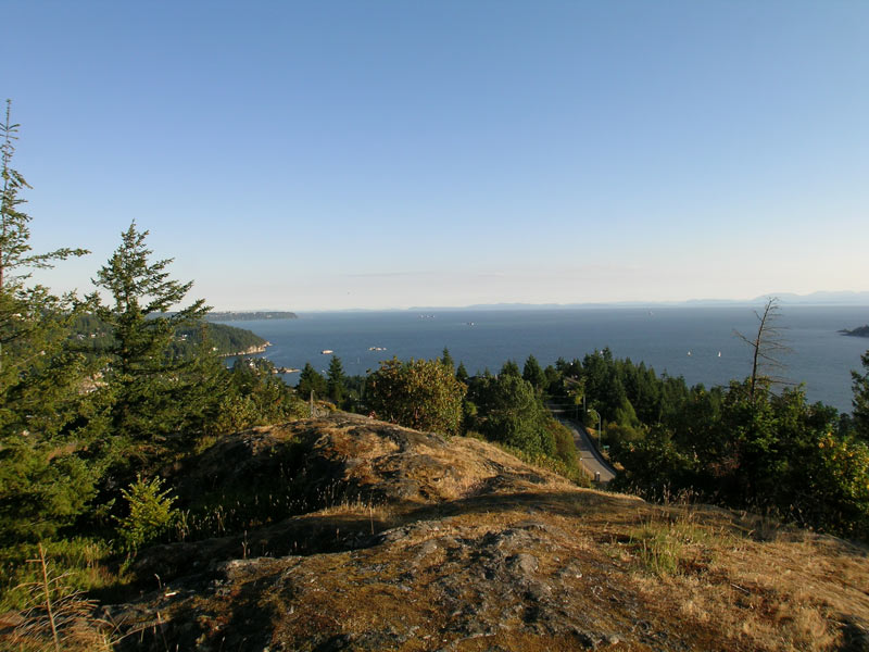 |
|
|
|
Post by Low Light Mike on Jan 2, 2014 21:22:10 GMT -8
A few photos to illustrate the ship-spotting opportunities at Sonitula, on Malcolm Island, BC The ferry berth is an off-shoot of the main town wharf structure, owned by the Lions Club. So there is a nice wharf with lots of photo op space. - to the left of the ferry dock is a nice beach with good views of the ferry and berth. Lots of easy access to this beach, from the vacant areas between the buildings. - the yellow building is the Co-op grocery store. The oldest Co-operative in BC (established by the Finn hippies in 1909) and the Co-op gas bar is to the right of the ferry dock. - my main photo-location for my late Dec.2013 trip is the bottom right corner of the Hotel, which is the red-roofed building to the left of the ferry dock. See a close-up photo at bottom of this post. 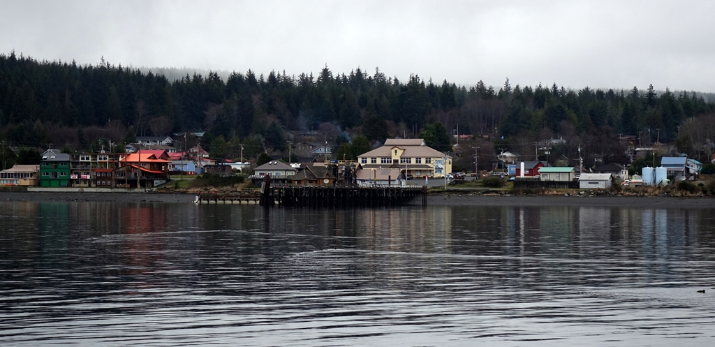 Here is the Malcolm Island Inn. A nice and simple hotel, with a pub (not too loud) and seasonal food service (non in off-season). If you want to stay in Sointula, this is a good place. - The bottom right corner of this building is a covered outside area where I set up a few times for filming of the ferry arriving & in-berth. A nice location, but you need to be a hotel patron to use it. - Otherwise, the beach is fine (although not at a winter high-tide, as seen in this photo !) - The grassy area to the right of the hotel provides public beach access. 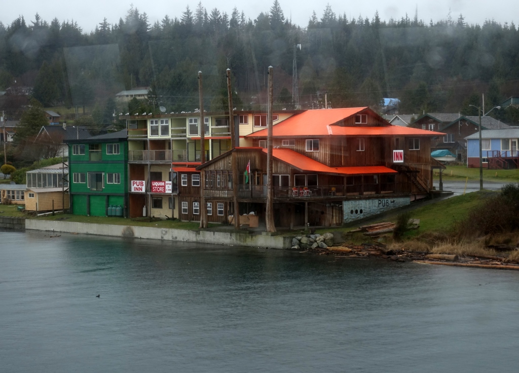 |
|
SolDuc
Voyager   West Coast Cyclist
SolDuc and SOBC - Photo by Scott
Posts: 2,055
|
Post by SolDuc on Oct 4, 2014 11:34:57 GMT -8
I've spent a fair amount of time at Pritchard park lately, and I want to mention that it's an awesome ferry spotting location. The beach on the Seattle side has awesome views of Rainier and the ferries go right in front. There's also a trail up on the bluff that provides very good bird's eye pictures. And of course there's the beach that points towards the ferry terminal and the maintenance facility. And all of that is without the point open to the public. It's going to be great when it's done! Oh, and they actually have a map of the final plan up at the park. It looks pretty sweet if you asked me! 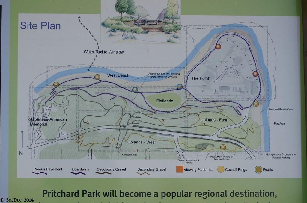 "Pritchard Park will become a popular regional destination" "Pritchard Park will become a popular regional destination" by SolDuc Photography, on Flickr |
|
|
|
Post by Low Light Mike on Jul 7, 2018 11:55:53 GMT -8
Here's the location of Bluffs Park on Galiano Island, from the perspective of the west entrance to Active Pass:  DSC01002 DSC01002 by Mike Bonkowski, on Flickr In a few days, I will post a driving video showing the road up to the Bluffs. |
|
|
|
Post by paulvanb on Jul 31, 2018 14:33:33 GMT -8
Doing a cruise to Alaska, leaving Saturday. Stops are Juneau, Skagway and Ketchikan. Where the best areas to photograph the blue canoes, either in port or in transit?
|
|
|
|
Post by WettCoast on Jul 31, 2018 15:36:46 GMT -8
Doing a cruise to Alaska, leaving Saturday. Stops are Juneau, Skagway and Ketchikan. Where the best areas to photograph the blue canoes, either in port or in transit? Ketchikan is good because the AMHS docks are not far from the the cruise ship berths and the channel is quite narrow so other ships are seen at close hand. It is also a hub of sorts so that ups your chances of seeing one or more 'Blue canoes". Skagway is good too, but ferries are not as frequent. Juneau is also a hub but the ferries go to Auke Bay which is quite a distance from downtown Juneau where the cruise ship berths are. There is also a good possibility of seeing ferries when you are in transit, but you have to be out on deck & ready to fire that shutter (and not holed up in one of the ship's lounges!). |
|
|
|
Post by paulvanb on Aug 1, 2018 20:01:58 GMT -8
Thank you for responding to this. Our weather, however, does not look promising.
|
|
|
|
Post by WettCoast on Aug 2, 2018 20:58:14 GMT -8
Thank you for responding to this. Our weather, however, does not look promising. Hindsight says you ought to have done this trip last week. But, you know, you just might get better weather than you think. Lets hope so, anyways. When in Skagway do a WP&YR rail trip. If possible do the trip all the way to Carcross, Yukon, if time and money allows, and it is available on the day you are there. |
|
|
|
Post by paulvanb on Aug 3, 2018 7:15:48 GMT -8
Thank you for responding to this. Our weather, however, does not look promising. Hindsight says you ought to have done this trip last week. But, you know, you just might get better weather than you think. Lets hope so, anyways. When in Skagway do a WP&YR rail trip. If possible do the trip all the way to Carcross, Yukon, if time and money allows, and it is available on the day you are there. We are going to the summit in the morning, then going on a photographic expedition in the afternoon. |
|
|
|
Post by Ollie on Feb 25, 2023 16:27:57 GMT -8
Is there anywhere for ferry photos in Horseshoe Bay that has the same view as this but without the large obstacle in the bottom left? Even for Langdale at berth 3 it is still blocking the view.
Berth 2
Berth 1 |
|
|
|
Post by WettCoast on Feb 25, 2023 22:04:24 GMT -8
Is there anywhere for ferry photos in Horseshoe Bay that has the same view as this but without the large obstacle in the bottom left? Even for Langdale at berth 3 it is still blocking the view.
Horseshoe Bay is a congested & busy little harbour and this makes unobstructed views of the ferries a bit tricky. Views from a higher vantage point, such as up by Troll's Restaurant might work, but you need a bit of a telephoto for this to work. Also, at water level there is only the one spot that I have used and that is a jetty over toward the west side of the bay. RCMSAR vessels are tied up at this jetty. You get good, but pretty limited views of the ferries coming & going. It get worse if there is any major work going on such as repairs/rehab for berth 1 at the ferry terminal. Then, you have to go with the elevated views from afar. You might also try to find out there is any possible way to legally & safely get to Tyee Point at the entrance to the bay on the west side. |
|
Neil
Voyager  
Posts: 7,307
|
Post by Neil on Feb 25, 2023 22:28:35 GMT -8
Is there anywhere for ferry photos in Horseshoe Bay that has the same view as this but without the large obstacle in the bottom left? Even for Langdale at berth 3 it is still blocking the view.
Horseshoe Bay is a congested & busy little harbour and this makes unobstructed views of the ferries a bit tricky. Views from a higher vantage point, such as up by Troll's Restaurant might work, but you need a bit of a telephoto for this to work. Also, at water level there is only the one spot that I have used and that is a jetty over toward the west side of the bay. RCMSAR vessels are tied up at this jetty. You get good, but pretty limited views of the ferries coming & going. It get worse if there is any major work going on such as repairs/rehab for berth 1 at the ferry terminal. Then, you have to go with the elevated views from afar. You might also try to find out there is any possible way to legally & safely get to Tyee Point at the entrance to the bay on the west side. WettCoast is so right. It's actually pretty amazing that so much is tucked into Horseshoe Bay. Three ferry berths and a huge terminal compound, a private marina with some commercial freight operations, a small public beach, as well as something of a town with condos and everything else. I don't know what the developable land area is, or the marine acreage, but, boy, is it tight. Black Ball set up there in 1951 or so, and it certainly made sense at the time. Now, though... it has to be one of the busiest pieces of land and marine real estate on our coast. So, the fact that there is some intruding dock structure in the shots of ferries... |
|
|
|
Post by paulvanb on Mar 26, 2023 20:45:38 GMT -8
Horseshoe Bay is a congested & busy little harbour and this makes unobstructed views of the ferries a bit tricky. Views from a higher vantage point, such as up by Troll's Restaurant might work, but you need a bit of a telephoto for this to work. Also, at water level there is only the one spot that I have used and that is a jetty over toward the west side of the bay. RCMSAR vessels are tied up at this jetty. You get good, but pretty limited views of the ferries coming & going. It get worse if there is any major work going on such as repairs/rehab for berth 1 at the ferry terminal. Then, you have to go with the elevated views from afar. You might also try to find out there is any possible way to legally & safely get to Tyee Point at the entrance to the bay on the west side. WettCoast is so right. It's actually pretty amazing that so much is tucked into Horseshoe Bay. Three ferry berths and a huge terminal compound, a private marina with some commercial freight operations, a small public beach, as well as something of a town with condos and everything else. I don't know what the developable land area is, or the marine acreage, but, boy, is it tight. Black Ball set up there in 1951 or so, and it certainly made sense at the time. Now, though... it has to be one of the busiest pieces of land and marine real estate on our coast. So, the fact that there is some intruding dock structure in the shots of ferries... Tyee Point is private property. You can catch ships coming and going from the old highway just south of the highway exit. If one had a drone, they could probably launch from there. A whole new look on Horseshoe Bay! |
|
|
|
Post by Ollie on Jul 29, 2023 19:08:14 GMT -8
Does anyone here know where this photo could have been taken? It looks like it would be somewhere on Mount Galiano but I have climbed it a few times and there was never any view from this angle, only to the south.
|
|
|
|
Post by WettCoast on Jul 29, 2023 20:26:05 GMT -8
Does anyone here know where this photo could have been taken? It looks like it would be somewhere on Mount Galiano but I have climbed it a few times and there was never any view from this angle, only to the south.
The famous once-upon-a-time CPR photographer Nick Morant took photos of Princess ships in Active Pass, decades ago. His vantage point was at or near this same spot. Its on the shoulder of Mt Galiano exactly where I don't know. Accessed from the trail head near the cemetery, I think. |
|
|
|
Post by Ollie on Jul 30, 2023 20:44:40 GMT -8
Does anyone here know where this photo could have been taken? It looks like it would be somewhere on Mount Galiano but I have climbed it a few times and there was never any view from this angle, only to the south.
The famous once-upon-a-time CPR photographer Nick Morant took photos of Princess ships in Active Pass, decades ago. His vantage point was at or near this same spot. Its on the shoulder of Mt Galiano exactly where I don't know. Accessed from the trail head near the cemetery, I think. Thank you, I went up Mount Galiano today to look for any other paths in the jungle but it seems like this specific location doesn't exist anymore. Currently it's just the one trail to the regular viewpoint. |
|
|
|
Post by paulvanb on Aug 5, 2023 13:17:53 GMT -8
The famous once-upon-a-time CPR photographer Nick Morant took photos of Princess ships in Active Pass, decades ago. His vantage point was at or near this same spot. Its on the shoulder of Mt Galiano exactly where I don't know. Accessed from the trail head near the cemetery, I think. Thank you, I went up Mount Galiano today to look for any other paths in the jungle but it seems like this specific location doesn't exist anymore. Currently it's just the one trail to the regular viewpoint. Then it is time to bushwhack! |
|